
Our dry spell is coming to an end, replaced by a soggy stretch of weather.
An area of low pressure is making its way up the southeast coast bringing scattered showers and storms today and again tomorrow.
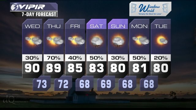
On Thursday a cold front will move in from the Midwest sparking more showers and storms with heavy downpours. Ahead of that front we expect high temperatures in the upper 80s and lower 90s both Wednesday and Thursday.
That front will hit the brakes across North Carolina on Friday and be the focus for more showers and storms all the way through the weekend and into early next week.
That means a good chance for showers and storms this weekend. But we'll also enjoy milder weather, with highs in the upper 70s and lower 80s.
Weather & Health for Wednesday
Pollen: Moderate-High (Ragweed, Grasses)
UV Index: High
Air Quality: Good
Mosquitoes: Very High
Today in Weather History (NWS Wakefield)
1804 Hurricane "Inconceivable" Damage - Coastal Virginia
2004 Tornado Outbreak: Central, East Central, VA (Frances)
Patrick Rockey
NewsChannel 3 Chief Meteorologist
Join me on Facebook HERE.
Follow me on Twitter HERE.
Check Interactive Radar here: http://wtkr.com/weather/maps-and-radar/interactive-radar/
