*A Coastal Flood Advisory is in effect for Chesapeake, Norfolk, Portsmouth, Suffolk, Isle of Wight Co., Surry Co. from 4 pm until 8 pm and Outer Banks Currituck Co. from 2 pm until 6 pm.*
Track showers in your neighborhood with the NewsChannel 3 Interactive Radar HERE.
Our bout with wet and windy weather will continue for the next few days. In fact the tidal flooding could become even more widespread this weekend.
Everything depends on what happens with the area of low pressure sitting off the Carolina coast.
Some forecast models bring it inland as we head into Friday and Saturday. That would bring us less flooding.
However, other forecast models park the low right off the mouth of the Chesapeake Bay. That would pump a lot of water into the bay, resulting in more widespread flooding at times of high tide this weekend.
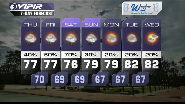
With the cloud cover and the strong northeast winds, expect high temperatures in the mid-to-upper 70s through the rest of the work week and the weekend.
Our rain chances continue in the 50 to 70% range through Saturday. As the area of low pressure approaches, we could see bands of heavier rain.
Right now, rain is also looking possible on Sunday, but the chances are lower.
It looks like we won't see significant sunshine until at least the middle of next week.
Weather & Health
Pollen: Low (Ragweed)
UV Index: Low
Air Quality: Good
Mosquitoes: Low
Today in Weather History (NWS Wakefield)
2003 Tornado Outbreak: Central, East Central, VA
Patrick Rockey
NewsChannel 3 Chief Meteorologist
Join me on Facebook HERE.
Follow me on Twitter HERE.
Check Interactive Radar here: http://wtkr.com/weather/maps-and-radar/interactive-radar/


