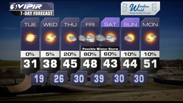
After unusually mild weather for about the last six weeks, the bottom is dropping out. That means dangerously cold and windy weather for the next few days and the possibility of a winter storm later this week.
An Arctic air mass is bringing us unseasonably cold temperatures, gusty winds and mainly clear skies. Most of us will wake up to temperatures in the teens on Tuesday morning with wind chills in the single digits.
And, despite plenty of sunshine, most of us probably won't break the freezing mark on Tuesday. In fact some of us may not even climb out of the 20s!
Wednesday morning brings more cold weather. But the winds will be lighter, so it won't feel quite as brutal. And by the afternoon we expect temperatures to be in the upper 30s and even some lower 40s.
Then our attention turns to a developing storm system that could bring us more wintry weather on Friday and Saturday.
There are a lot of moving parts with this system and a lot of uncertainty. As an area of low pressure moves up the coast, it looks like we will be right on the line between rain and snow.
If the coldest air stays just to our north, we are looking at a chilly rain.
If the cold air dives farther south, we could be looking at quite a bit of snow.
We will continue to fine-tune that forecast over the next few days. Check in with us often!
Today in Weather History (NWS Wakefield)
1857 Winter Weather: Severe Snowstorm, Heavy Snowfall interior VA, Richmond cut off from DC
Patrick Rockey
NewsChannel 3 Chief Meteorologist
Join me on Facebook HERE.
Follow me on Twitter HERE.
Check Interactive Radar here: http://wtkr.com/weather/maps-and-radar/interactive-radar/


