


Meteorologist Myles Henderson’s First Warning Forecast
Tracking rain for Election Day… Expect another cool start this morning with temperatures in the 40s and 50s. We will see some sunshine this morning, but clouds will build in by midday to the afternoon. Scattered showers will move in from west to east this afternoon to evening. Highs will return to the mid 60s, near normal for this time of year.
Cooler air moves in the for the second half of the week. Highs will drop to the mid 50s on Wednesday with partly cloudy skies. Rain will return for Thursday and Friday as a string of fronts lingers just off the East Coast. Winds will ramp up for the second half of the work week and could trigger some tidal flooding. Highs will remain in the mid 50s for Thursday and Friday.
Clouds and showers may stick around for Saturday, but we should see clearing skies on Sunday. It will be windy all weekend with gusts to 30+ mph possible both days. Highs will warm to the upper 50s and low 60s.
Today: Clouds Building In, PM Showers. Highs in the mid 60s. Winds: E/N 5-10
Tonight: Mostly Cloudy, Scattered Showers. Lows in the upper 40s. Winds: N 5-10
Tomorrow: Partly Cloudy, Cooler. Highs in the mid 50s. Winds: N 10-15
Weather & Health
Pollen: Low (Ragweed)
UV Index: 2 (Low)
Air Quality: Good (Code Green)
Mosquitoes: Moderate
Tropical Update
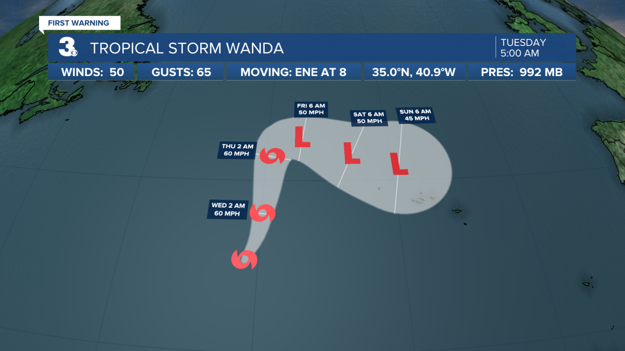
Tropical Storm Wanda a little stronger over open Atlantic. Wanda is centered about 800 miles west of the Azores and moving ENE at 8 mph. A turn toward the NE and NNE is expected today, followed by a generally northward motion at a slightly faster forward speed through Wednesday. Maximum sustained winds have increased to near 50 mph with higher gusts. Little change in strength is forecast during the next 48 hours.
A low-pressure system located just offshore the northern coast of Panama is producing some disorganized showers and thunderstorms over the southwestern Caribbean Sea. This system is expected to move west over Central America later today, and significant development is unlikely due to its interaction with land.
* Formation chance through 48 hours: Low (10%)
* Formation chance through 5 days: Low (10%)
Weather updates on social media:
Facebook: MylesHendersonWTKR
Twitter: @MHendersonWTKR
Instagram: @MylesHendersonWTKR
