


Meteorologist Myles Henderson’s First Warning Forecast
Warm, muggy, more rain on the way… We will see a mix of clouds (partly to mostly cloudy) today with an isolated shower possible. It will still be warm and muggy with highs in the mid to upper 80s and an afternoon heat index in the mid 90s.
Expect highs in the upper 80s tomorrow with a heat index in the mid to upper 90s. We will see a mix of clouds again tomorrow with scattered showers and storms possible, mainly later in the day.
Highs will linger in the upper 80s to low 90s to end the week and it will still be humid. Expect a mix of sun and clouds with afternoon scattered showers and storms possible.
This weekend will be very typical for August. We will see a nice mix of sun and clouds, with scattered showers/storms popping up in the afternoon. Highs will remain in the upper 80s with an afternoon heat index in the mid 90s.
Today: Mix of Clouds, Isolated Shower. Highs in the upper 80s. Winds: SE 5-15
Tonight: Mix of Clouds, Isolated Shower. Lows in the mid 70s. Winds: S 5-10
Tomorrow: Mix of Clouds, Afternoon Storms. Highs in the upper 80s. Winds: S 5-15
Weather & Health
Pollen: Medium (Grasses)
UV Index: 8 (Very High)
Air Quality: Good (Code Green)
Mosquitoes: Extreme
Tropical Update
Tropical depression Fred is moving toward the north-northeast near 17 mph and this motion is expected to continue through today with a gradual acceleration to the northeast through Wednesday. Maximum sustained winds are near 30 mph with higher gusts. Little change in strength is forecast during the next 48 hours.

Grace is moving toward the west near 15 mph. A general westward to west-northwestward motion is expected for the next several days. On the forecast track, the center of Grace will continue to move near the northern coast of Jamaica this afternoon. Grace is forecast to move near or over the Cayman Islands late tonight and early Wednesday, and then approach the Yucatan peninsula of Mexico late Wednesday or early Thursday. Maximum sustained winds are near 50 mph with higher gusts. Grace is forecast to strengthen into a hurricane on Wednesday, with some additional strengthening possible prior to the center reaching the Yucatan Peninsula. Tropical-storm-force winds extend outward up to 70 miles from the center.

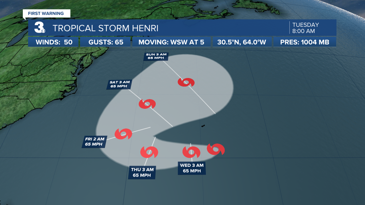
Henri is moving toward the west-southwest near 6 mph. A faster motion toward the west is forecast by tonight, followed by a motion to the west-northwest or northwest by late Thursday. On the forecast track, the center of Henri should pass well to the south of Bermuda through tonight. Maximum sustained winds remain near 50 mph with higher gusts. Some strengthening is possible during the next day or so. Tropical-storm-force winds extend outward up to 35 miles from the center.
Weather updates on social media:
Facebook: MylesHendersonWTKR
Twitter: @MHendersonWTKR
Instagram: @MylesHendersonWTKR
