


Meteorologist Myles Henderson’s First Warning Forecast
**FLASH FLOOD WATCH until 10 PM Monday for York, James City, Williamsburg, Gloucester, Mathews, Middlesex

Several rain chances this week… The combination of a stationary front and the remnants of Tropical Storm Fred will bring rain and storms to a large portion of the Southeast and Mid-Atlantic this week. We can expect a mix of clouds today with scattered showers and storms. Severe storms are not expected, but heavy downpours are likely with localized flooding possible.
We will see partly to mostly cloudy skies Tuesday and Wednesday with scattered showers possible. Rain and storm chances will be lower. Highs will linger in the mid to upper 80s, near normal for this time of year. It will still be very humid, so it will feel more like the 90s.
Highs will linger in the upper 80s to end the week. Expect a mix of sun and clouds with afternoon scattered showers and storms possible. This trend will continue into the weekend.
Today: Mix of Clouds, Showers/Storms. Highs in the mid 80s. Winds: SE 5-10
Tonight: Mix of Clouds, Scattered Showers. Lows in the mid 70s. Winds: S 5-10
Tomorrow: Mix of Clouds, Scattered Showers. Highs in the upper 80s. Winds: SE 5-15
Weather & Health
Pollen: Low (Grasses)
UV Index: 9 (Very High)
Air Quality: Good (Code Green)
Mosquitoes: Extreme
Tropical Update
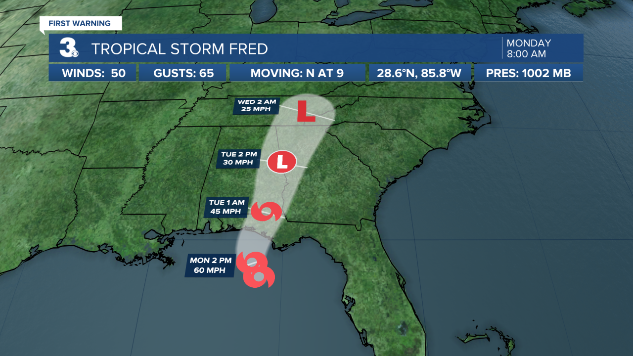
Tropical Storm Fred is expected to bring a dangerous storm surge and heavy rains to the Florida panhandle and big bend. Fred is moving toward the north near 10 mph, and this general motion is expected through tonight.
On the forecast track, the center of Fred should make landfall in the eastern Florida Panhandle this afternoon or early this evening, and move over western Georgia on Tuesday. Maximum sustained winds are near 60 mph with higher gusts. Some strengthening is possible before landfall. After landfall, Fred is expected to quickly weaken. Tropical-storm-force winds extend outward up to 115 miles from the center.
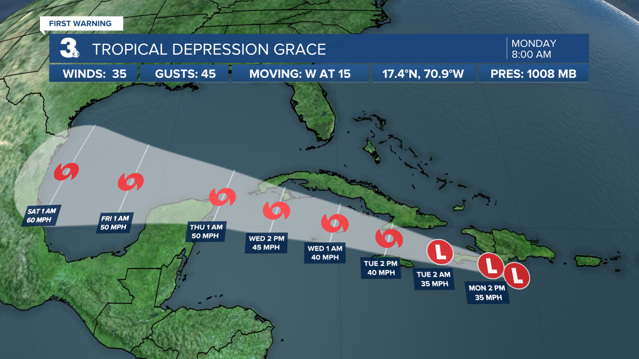
The center of Tropical Storm Grace is just about to cross the Barahona Peninsula of the Dominican Republic. Grace is moving toward the west near 15 mph. A westward to west-northwestward motion is expected over the next several days.
On the forecast track, the center of Grace will pass near the southern coast of Hispaniola today and tonight, and then pass between Jamaica, Cuba, and the Cayman Islands on Tuesday and Wednesday. Maximum sustained winds are near 35 mph with higher gusts. Some strengthening is forecast during the next few days, and Grace is expected to become a tropical storm again by Tuesday.
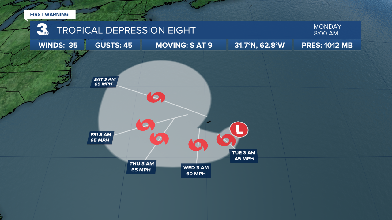
Tropical Depression Eight almost a tropical storm. The depression is moving toward the south near 9 mph. A slow clockwise turn toward the southwest and then toward the west is expected during the next few days. On the forecast track, the center of the depression will move well to the south of Bermuda. Maximum sustained winds are near 35 mph with higher gusts. Some strengthening is forecast during the next few days, and the depression is expected to become a tropical storm later today.
Weather updates on social media:
Facebook: MylesHendersonWTKR
Twitter: @MHendersonWTKR
Instagram: @MylesHendersonWTKR
