


Meteorologist Myles Henderson’s First Warning Forecast
Heat and humidity building… Highs will climb to the low 90s today, a few degrees warmer than yesterday. The heat index will reach the upper 90s this afternoon. Expect a nice mix of mostly sunny to partly cloudy skies today with slim rain chances.
Highs will linger in the low to mid 90s for the rest of the week. The afternoon heat index will climb to 100+ for Wednesday, Thursday, and Friday. Expect a mix of sun and clouds each day with an afternoon “pop-up” shower or storms possible.
The chance for showers and storms will go up for the end of the work week and the weekend as a cold front moves in. The cold front will drop temperatures back to the 80s on Sunday.
Today: Mostly Sunny to Partly Cloudy. Highs in the low 90s. Winds: S 5-10
Tonight: A Few Clouds. Lows in the mid 70s. Winds: SW 5-10
Tomorrow: Mostly Sunny to Partly Cloudy. Highs in the low 90s. Winds: SW 5-15
Weather & Health
Pollen: Medium (Grasses)
UV Index: 9 (Very High)
Air Quality: Good (Code Green)
Mosquitoes: Extreme
Tropical Update
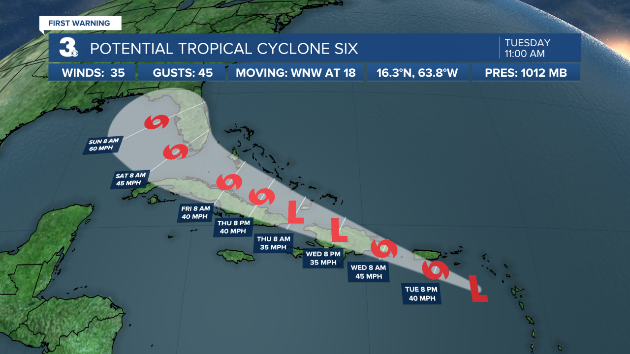
Potential Tropical Cyclone Six is not yet a tropical cyclone, likely to become a tropical storm later today or tonight. This system is centered about 220 miles ESE of Puerto Rico and moving WNW at 18 mph. This general motion is expected to continue during the next few days.
On the forecast track, the disturbance is expected to pass near or over the U.S. Virgin Islands and Puerto Rico later today and tonight, near or over Hispaniola on Wednesday, and near the southeastern Bahamas and the Turks and Caicos Islands Thursday.
Reports from a NOAA Hurricane Hunter aircraft indicate that maximum sustained winds are near 35 mph with higher gusts. However, the aircraft did not find a well-defined closed circulation. Gradual strengthening is forecast during the next day or so and the disturbance is expected to become a tropical storm later today or tonight. Some weakening is likely while the system interacts with Hispaniola on Wednesday.
Weather updates on social media:
Facebook: MylesHendersonWTKR
Twitter: @MHendersonWTKR
Instagram: @MylesHendersonWTKR
