


Meteorologist Myles Henderson’s First Warning Forecast
More heat and humidity… Highs will climb to the low and mid 90s today, a couple degrees warmer than yesterday. The heat index will reach 100+ this afternoon. Expect a nice mix of mostly sunny to partly cloudy skies today with slim rain chances.
Highs will linger in the mid 90s for the rest of the work week. The afternoon heat index will climb to near 105 Thursday, and Friday. Expect a mix of sun and clouds each day with an afternoon “pop-up” shower or storms possible.
The chance for showers and storms will go up for the weekend as a cold front moves in. Expect clouds, showers, and storms to move in later Saturday (mainly Saturday night) and continue for Sunday. The cold front will drop temperatures from the low 90s on Saturday to the mid 80s on Sunday.
Today: A Few Clouds. Highs in the low to mid 90s. Winds: SW 5-15
Tonight: A Few Clouds. Lows in the mid 70s. Winds: SW 5-10
Tomorrow: Mostly Sunny to Partly Cloudy. Highs in the mid 90s. Winds: SW 5-10
Weather & Health
Pollen: Medium (Grasses)
UV Index: 9 (Very High)
Air Quality: Good (Code Green)
Mosquitoes: Extreme
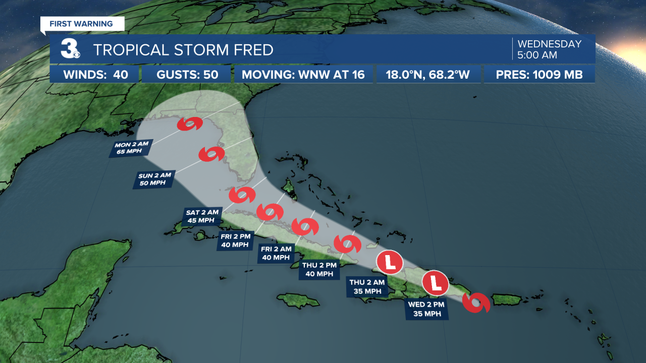
Tropical Update
Tropical Storm Fred is moving toward the west-northwest near 16 mph, and a general west-northwestward motion is expected to begin later today and continue for the next few days. On the forecast track, the center of Fred is expected to be near or over Hispaniola later today, move near the Turks and Caicos Islands and the southeastern Bahamas on Thursday, and move north of the northern coast of central Cuba on Friday. Maximum sustained winds are near 40 mph with higher gusts. Some weakening is likely while the system interacts with Hispaniola today.
Tropical-storm-force winds extend outward up to 45 miles from the center.
Tracking a tropical wave located a few hundred miles southwest of the Cabo Verde Islands. Some gradual development is possible over the next several days while the system moves generally west across the tropical Atlantic.
* Formation chance through 48 hours: Low (20%)
* Formation chance through 5 days: Low (30%)
Weather updates on social media:
Facebook: MylesHendersonWTKR
Twitter: @MHendersonWTKR
Instagram: @MylesHendersonWTKR
