


Meteorologist Myles Henderson’s First Warning Forecast
Building heat and humidity. Tracking storms for Thursday and Friday.
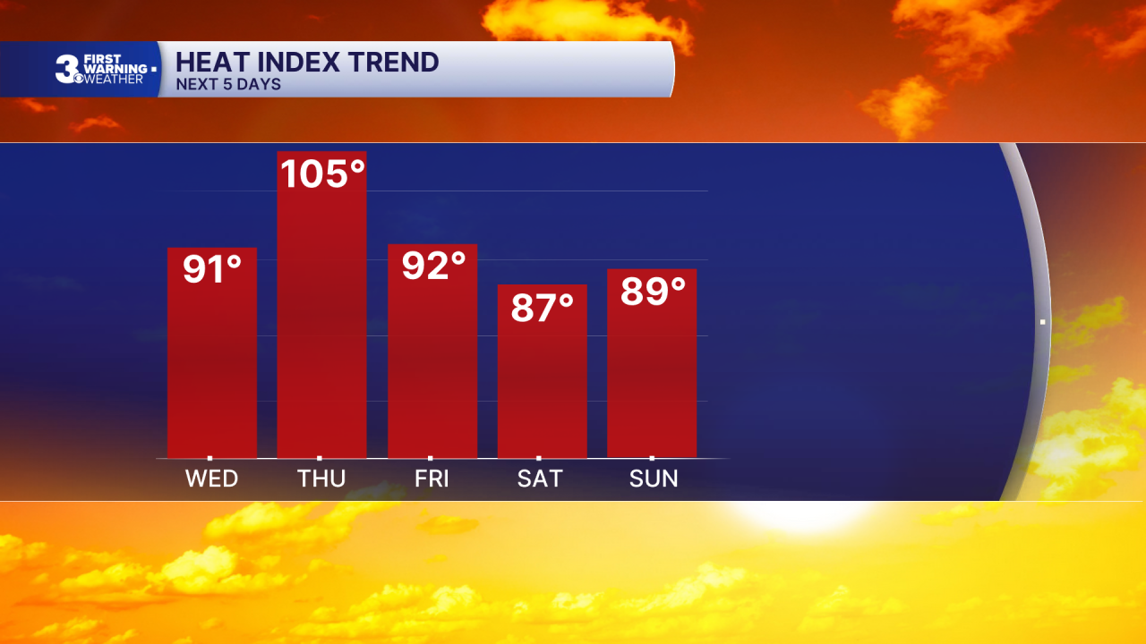
A step warmer today with highs in the upper 80s, about 10 to 15 degrees warmer than yesterday. Expect clouds in the morning with more sunshine by midday.

The heat and humidity crank up for Thursday. Highs will reach the upper 90s with an afternoon heat index near 105. We will see a mix of mostly sunny to partly cloudy skies with scattered showers and storms developing in the afternoon to evening. The wind will also pick up with gusts to 30 mph. Some storms could be strong to severe with damaging wind gusts and localized flooding.

Showers and storms move through Friday with a cold front. The biggest storm chances will be midday through the afternoon. Highs will drop to the mid 80s, but it will still be humid.
The weekend looks nice. We will see mostly sunny skies with highs in the mid to upper 80s both days. It will also be less humid this weekend, compared to the end of the work week.
Today: Clearing Skies. Highs in the upper 80s. Winds: SW 5-10
Tonight: Mainly Clear. Lows in the mid 70s. Winds: S 5-10
Tomorrow: Partly Cloudy, PM Storms. Highs in the upper 90s. Winds: SW 10-20G30
Weather & Health
Pollen: Low-Moderate (Grasses)
UV Index: 9 (Very High)
Air Quality: Good (Code Green)
Mosquitoes: Very High
Tropical Update
Tropical Storm Arthur forms along the Texas coast. On the forecast track, the low pressure area should move northeastward along the Texas coast today and then move inland over southwestern Louisiana by tonight.
Surface observations and data from the Air Force Reserve Hurricane Hunters indicate that maximum sustained winds have increased to near 40 mph with higher gusts. Little change in strength is expected before the center moves over land. Weakening is anticipated once the low moves inland, and it could dissipate by tonight or early Thursday.

Weather updates on social media:
Facebook: MylesHendersonWTKR
Instagram: @MylesHendersonWTKR
