


Meteorologist Myles Henderson’s First Warning Forecast
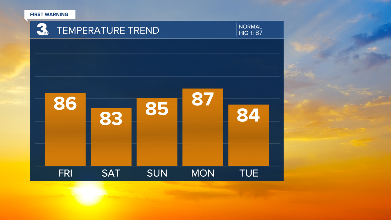
A nicer weekend ahead with lower rain chances. Several days in the mid 80s.
Watch out for areas of dense fog this morning. Highs will return to the mid 80s today, but it will still feel like the 90s with the humidity. Expect partly cloudy skies with scattered showers/storms, mainly this afternoon. Heavy downpours could once again trigger some localized flooding.

Rain chances and the temperature will come down a bit for the weekend. Expect highs in the mid 80s with mostly sunny to partly cloudy skies and slightly lower humidity.
Highs will linger in the mid 80s for the first part of next week. Expect partly cloudy skies and small rain chances.
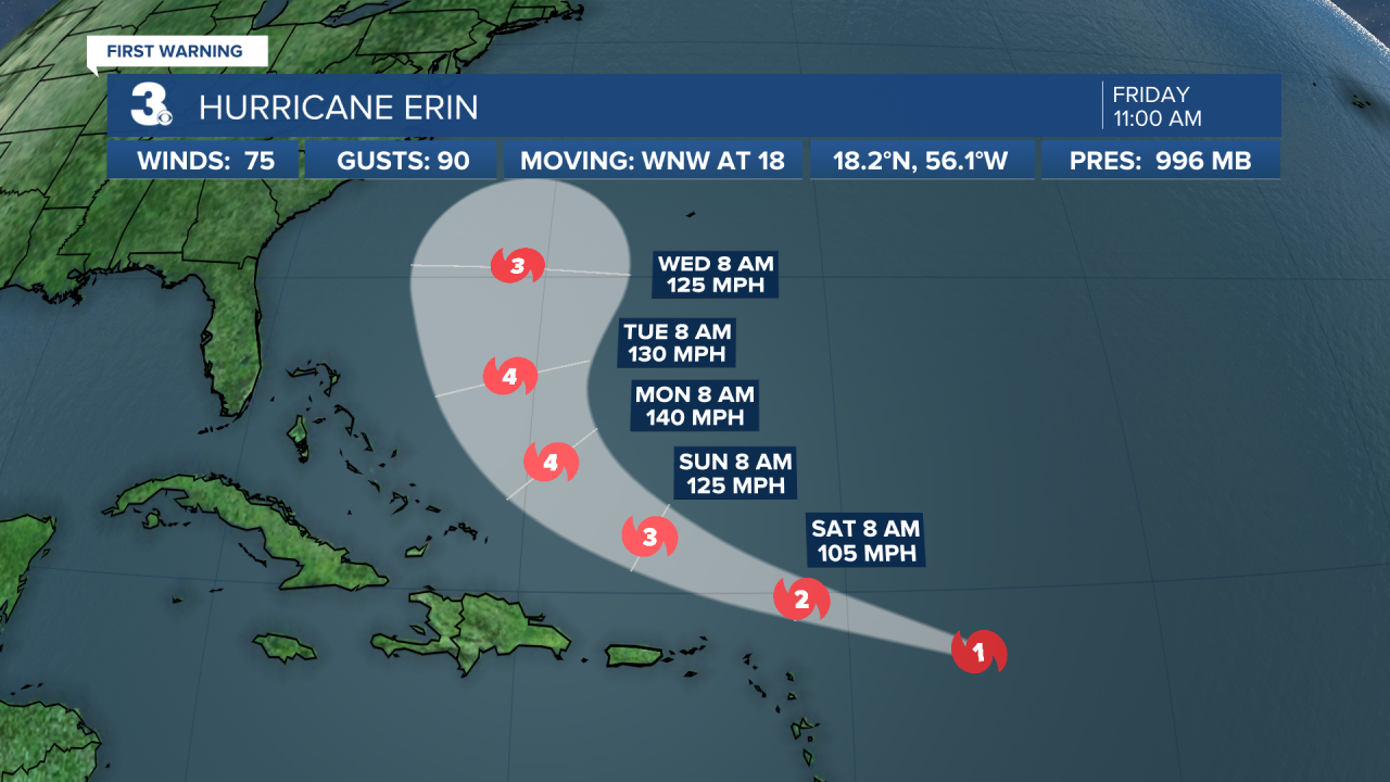
Erin is forecast to track parallel to the East Coast next week. It will likely be closest to VA/NC on Thursday. The exact track will determine how much of an impact we see.
Today: Afternoon Storms. Highs in the mid 80s. Winds: NE 5-10
Tonight: Partly Cloudy. Lows in the mid 70s. Winds: NE 5-10
Tomorrow: Partly Cloudy. Highs in the mid 80s. Winds: NE 5-15
Weather & Health
Pollen: Medium-High (Ragweed, Grasses)
UV Index: 10 (Very High)
Air Quality: Good (Code Green)
Mosquitoes: Extreme
Tropical Update
Erin becomes the first hurricane of the 2025 season. Erin is centered about 460 miles east of the northern Leeward Islands and moving WNW at 18 mph. On the forecast track, the center of Erin is likely to move near or just north of the northern Leeward Islands over the weekend.
Reports from NOAA and Air Force Reserve Hurricane Hunter aircraft indicate that maximum sustained winds have increased to near 75 mph with higher gusts. Steady to rapid strengthening is expected during the next two to three days, and Erin is forecast to
become a major hurricane during the weekend.
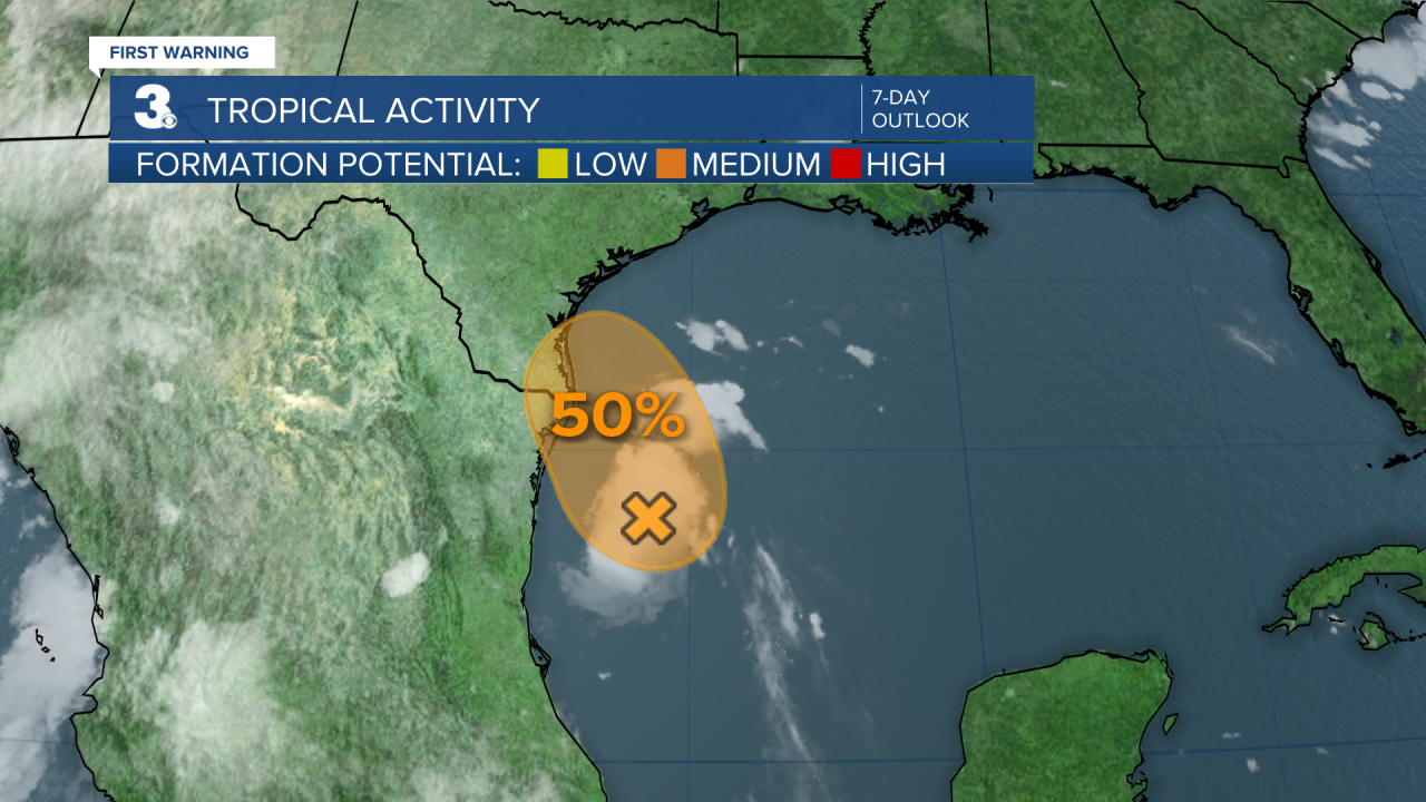
Tracking a disturbance over the western Gulf. The system could become a short-lived tropical depression before it moves inland over northeastern Mexico or southern Texas this afternoon or evening.
* Formation chance through 48 hours: Medium (50%)
* Formation chance through 7 days: Medium (50%)
Weather updates on social media:
Facebook: MylesHendersonWTKR
Instagram: @MylesHendersonWTKR
