


Meteorologist Myles Henderson’s First Warning Forecast
Scattered showers and windy to end the work week. Highs in the 80s this weekend. Warming up next week.
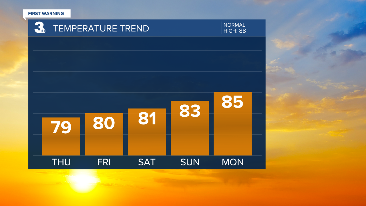
Mostly cloudy today with scattered showers throughout the day. Highs will struggle to reach the 80s today with more humidity. It will be windy with a NE wind at 10 to 20 and gusts to 25 mph.

Very similar conditions for Friday. A mix of clouds with scattered showers. Highs near 80 and a NE wind at 10 to 20 mph.
Highs will reach the low to mid 80s this weekend. Expect partly cloudy skies with lower chances for showers. The wind will also relax through the weekend.
Temperatures will start to climb again early next week. Highs will reach 90 by midweek with afternoon heat index values to near 100.
Today: Scattered Showers. Highs in the upper 70s. Winds: NE 10-20
Tonight: Scattered Showers. Lows in the low 70s. Winds: NE 10-15
Tomorrow: Scattered Showers. Highs near 80. Winds: NE 10-20
Weather & Health
Pollen: Low-Medium (Grasses)
UV Index: 1 (Low)
Air Quality: Moderate (Code Yellow)
Mosquitoes: Extreme
Tropical Update
Tropical Storm Dexter is forecast to become an extratropical low over the northern Atlantic today. An ENE to NE motion is expected during the next couple of days. Maximum sustained winds are near 50 mph with higher gusts. Dexter is expected to strengthen as an extratropical low later today through Friday. The cyclone is forecast to weaken beginning Friday night to Saturday.

Tracking a tropical wave over the eastern tropical Atlantic. Environmental conditions are forecast to be generally conducive for gradual development, and a tropical depression could form over the weekend while the system moves NW across the central tropical and subtropical Atlantic.
* Formation chance through 48 hours: Low (20%)
* Formation chance through 7 days: Medium (60%)
Watching a weak area of low pressure located a few hundred miles off the coast of the southeastern United States. Some slow tropical or subtropical development is possible over the weekend and early next week while the system moves north to northeast, remaining off the East Coast.
* Formation chance through 48 hours: Low (0%)
* Formation chance through 7 days: Low (30%)

Weather updates on social media:
Facebook: MylesHendersonWTKR
Instagram: @MylesHendersonWTKR
