


Meteorologist Myles Henderson’s First Warning Forecast
Rain and storms moving in, plus a threat for severe weather. Still warm to end the work week but trending cooler for the weekend.
Expect a mix of clouds today (partly to mostly cloudy) with a few scattered showers possible. It will still be warm today with highs returning to the low 70s. Rain chances will increase this evening and tonight as a cold front moves in.

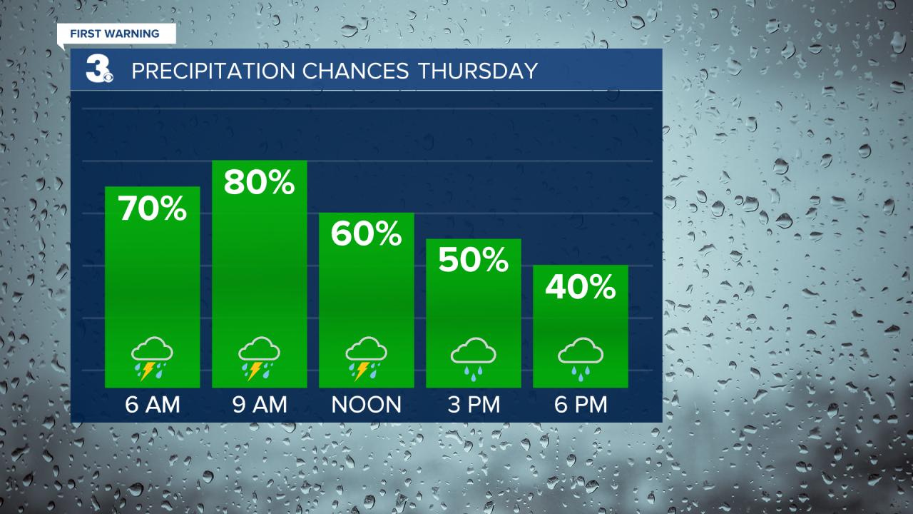
Rain and storm chances will continue for Thursday. Strong to severe thunderstorms are possible, including damaging wind gusts, localized flooding, pockets of hail, and isolated tornadoes. Rain chances will be higher in the morning to midday and dropping by the afternoon to evening. It will still be warm with highs in the low 70s.
We will get a chance to dry out on Friday with highs falling to the mid and upper 60s and partly cloudy skies.
Even cooler air is set to move in this weekend with highs in the low 60s on Saturday and mid 50s on Sunday. A few spotty showers are possible Saturday, but we will see partly cloudy skies most of the weekend. Winds will ramp up, west at 10 to 20 on Saturday and NW at 10 to 20 with gusts to 30 mph on Sunday.

Today: Mostly Cloudy, Scattered Showers. Highs in the low 70s. Winds: SE 5-15
Tonight: Rain & Storms, Breezy. Lows in the mid 60s. Winds: S 10-15G25
Tomorrow: Rain & Storms, Breezy. Highs in the low 70s. Winds: S 10-15
Weather & Health
Pollen: Medium-High (Juniper, Birch, Sycamore)
UV Index: 4 (Moderate)
Air Quality: Moderate (Code Yellow)
Mosquitoes: Low
Weather updates on social media:
Facebook: MylesHendersonWTKR
Twitter: @MHendersonWTKR
Instagram: @MylesHendersonWTKR
