


Meteorologist Myles Henderson’s First Warning Forecast
Hurricane Erin to brush by the North Carolina coast on Thursday. Clearing, calming, and lower humidity to end the week.
Partly to mostly cloudy skies today with scattered showers. Expect highs in the mid 80s, but it will feel more like the low to mid 90s with the humidity. Winds will start to pick up through the day.

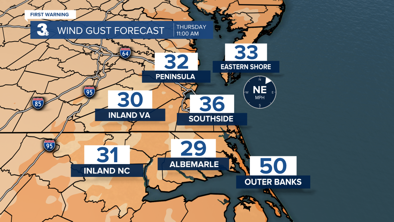
Hurricane Erin is forecast to slide just off the NC coastline Thursday. Even though the core of this storm is expected to stay over the water, we will still feel the outside impacts. Expect several days of rough surf and high risk for rip currents. Coastal flooding threats will increase for Thursday and ocean overwash is likely along the Outer Banks. The biggest flooding threat will be near high tide Thursday evening. The wind will ramp up Thursday, with gusts reaching 40 to 60 mph along the coast. Expect scattered showers as the outer rain bands wrap inland.
The wind will gradually back down, and skies will clear on Friday. Highs will drop to near 80 with lower humidity. Highs will remain in the low to mid 80s this weekend.
Today: Scattered Showers. Highs in the mid 80s. Winds: N/E 5-15
Tonight: Mostly Cloudy. Lows in the mid 70s. Winds: E 10-20
Tomorrow: Scattered Showers, Windy. Highs in the low 80s. Winds: NE 20-30 G40
Weather & Health
Pollen: Medium (Ragweed, Grasses)
UV Index: 8 (High)
Air Quality: Good (Code Green)
Mosquitoes: Extreme
Tropical Update
Hurricane Erin is centered about 365 miles SSE of Cape Hatteras, NC. A Tropical Storm Warning is in effect from Beaufort Inlet, NC to Chincoteague, VA including the Albemarle and Pamlico Sounds. A Storm Surge Warning is in effect for Cape Lookout to Duck, NC.
A turn toward the NNE is expected later today and tonight, followed by a faster motion toward the NE and ENE by Thursday and Friday. On the forecast track, the center of Erin will move over the western Atlantic between the U.S. east coast and Bermuda today through early Friday and then pass south of Atlantic Canada Friday and Saturday.
Maximum sustained winds have increased to near 110 mph with higher gusts. Some additional strengthening is likely during the next day or so, and Erin could become a major hurricane again by tonight. Weakening is likely to begin by Friday, but Erin is forecast to remain a hurricane into the weekend.
Erin is a large hurricane. Hurricane-force winds extend outward up to 90 miles from the center and tropical-storm-force winds extend outward up to 265 miles.

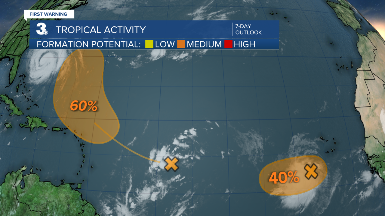
Tracking a tropical wave over the central tropical Atlantic. Environmental conditions appear conducive for gradual development of this system, and a tropical depression could form late this week or over the weekend while it moves near the northern Leeward Islands.
* Formation chance through 48 hours: Low (10%)
* Formation chance through 7 days: Medium (60%)
Tracking a tropical wave to the southwest of the Cabo Verde Islands. Environmental conditions appear marginally favorable for additional development over the next day or so while the system moves west. A short-lived tropical depression could form. By the end of the week, environmental conditions are expected to become unfavorable for further development.
* Formation chance through 48 hours: Medium (40%)
* Formation chance through 7 days: Medium (40%)
Weather updates on social media:
Facebook: MylesHendersonWTKR
Instagram: @MylesHendersonWTKR
