


Meteorologist Myles Henderson’s First Warning Forecast
Feeling more like fall with cooler temperatures and lower humidity.
A cooler start to the day with temperatures in the 50s and 60s this morning. We will only warm to near 70 today. Expect partly cloudy skies with slim rain chances and lower humidity. It will still be windy today (NE at 10-20 mph), but not as gusty as yesterday.

Friday looks like the nicest day of the work week. Very fall-like with highs in the low 70s and lower humidity. We will see partly cloudy skies with lighter winds.
The weekend looks great! Mostly sunny both days with highs in the mid to upper 70s, near normal for this time of year.

We will gradually warm back into the 80s by early next week. Our next rain chance is set to move in on Wednesday with a cold front.
Today: Partly Cloudy, Windy. Highs near 70. Winds: NE 10-20
Tonight: Partly Cloudy. Lows in the upper 50s. Winds: NE 10-15
Tomorrow: Partly Cloudy. Highs in the low 70s. Winds: NE 5-10
Weather & Health
Pollen: Low-Medium (Ragweed, Sagebrush)
UV Index: 4 (Medium)
Air Quality: Good (Code Green)
Mosquitoes: Very High
Tropical Update
Imelda becomes a strong extratropical cyclone over the central Atlantic. A general northeast motion will continue over the next few days. Gradual weakening is forecast over the next few days, but the post-tropical cyclone will remain a large and powerful system as it moves across the central Atlantic.
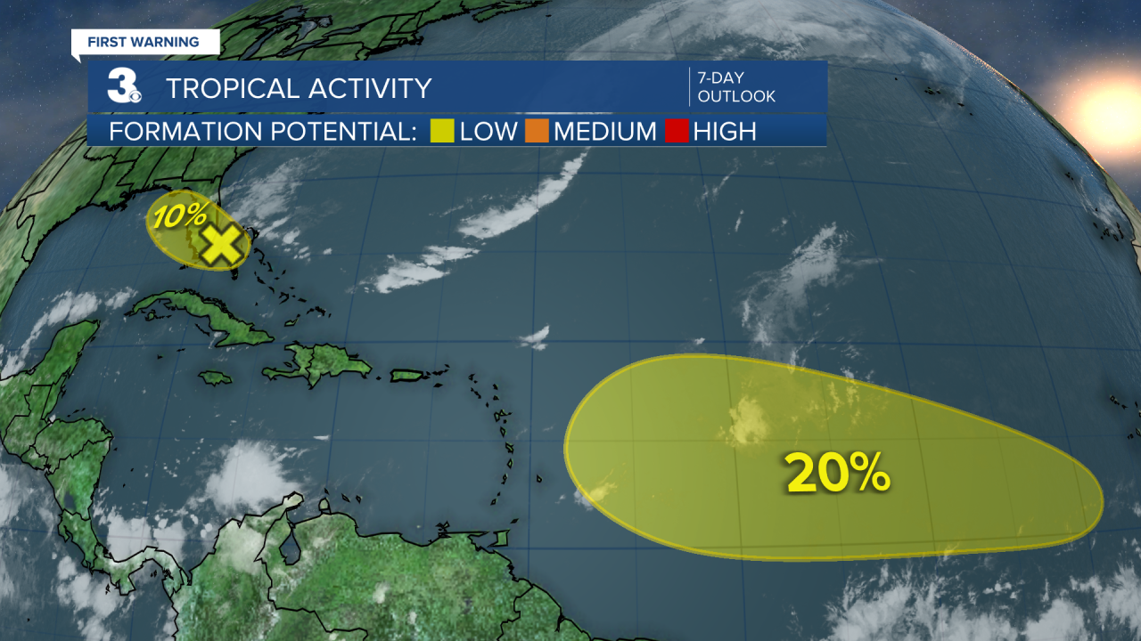
A tropical wave is expected to move off the coast of Africa over the next day or two. Some slow development is possible as the system moves west to WNW over the Atlantic.
* Formation chance through 48 hours: Low (0%)
* Formation chance through 7 days: Low (20%)
An area of low pressure may form near the northwestern Bahamas and southern Florida by Saturday. Any additional development is expected to be slow to occur as the system moves NW across Florida.
* Formation chance through 48 hours: Low (10%)
* Formation chance through 7 days: Low (10%)
Weather updates on social media:
Facebook: MylesHendersonWTKR
Instagram: @MylesHendersonWTKR
