


Meteorologist Myles Henderson’s First Warning Forecast
Heat and humidity return this weekend… Highs will warm to the upper 80s today, a small step warmer than yesterday. We will see mostly sunny skies today with a few extra clouds from time to time. South to southwest winds will pick up this afternoon to evening.
We will be back to a summer-like pattern this weekend. Highs will warm to the mid 90s on Saturday. With more humidity, afternoon heat index values will climb to near 100. Highs will drop to the low 90s on Sunday, but it will still feel like the mid to upper 90s. A “pop-up” shower or storm is possible in the afternoon to evening, but most of the weekend will be dry with a mix of sun and clouds.
We are watching an area of low pressure over the Gulf of Mexico that is expected to become a tropical system. This system will likely make landfall along the U.S. Gulf Coast this weekend. The leftover moisture from this system will spread over the Southeast early next week. We will see showers and storms on Monday from this system.
Today: A Few Clouds. Highs in the upper 80s. Winds: S/SW 5-15
Tonight: A Few Clouds. Lows in the low 70s. Winds: SW 10-15
Tomorrow: Partly Cloudy, Hot & Humid. Highs in the mid 90s. Winds: SW 10-15
Weather & Health
Pollen: Medium (Grasses)
UV Index: 10 (Very High)
Air Quality: Good (Code Green)
Mosquitoes: Very High
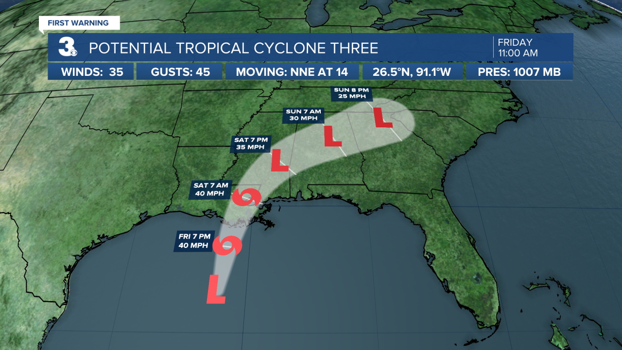
Tropical Update
Heavy rainfall and gusty winds beginning to reach portions of the northern gulf coast. Potential tropical cyclone three is centered about 220 miles south of Morgan City, Louisiana and moving NNE at 14 mph. This general motion is expected for the next day or so. On the forecast track, the system will make landfall along the north-central Gulf Coast tonight or early Saturday. A slow northeast motion across the southeastern United States is likely after landfall through the weekend.
Maximum sustained winds are near 35 mph with higher gusts. Some strengthening is forecast, and a subtropical or tropical storm is likely to form over the central or northern Gulf of Mexico later today.
Weather updates on social media:
Facebook: MylesHendersonWTKR
Twitter: @MHendersonWTKR
Instagram: @MylesHendersonWTKR
