


Meteorologist April Loveland's First Warning Forecast
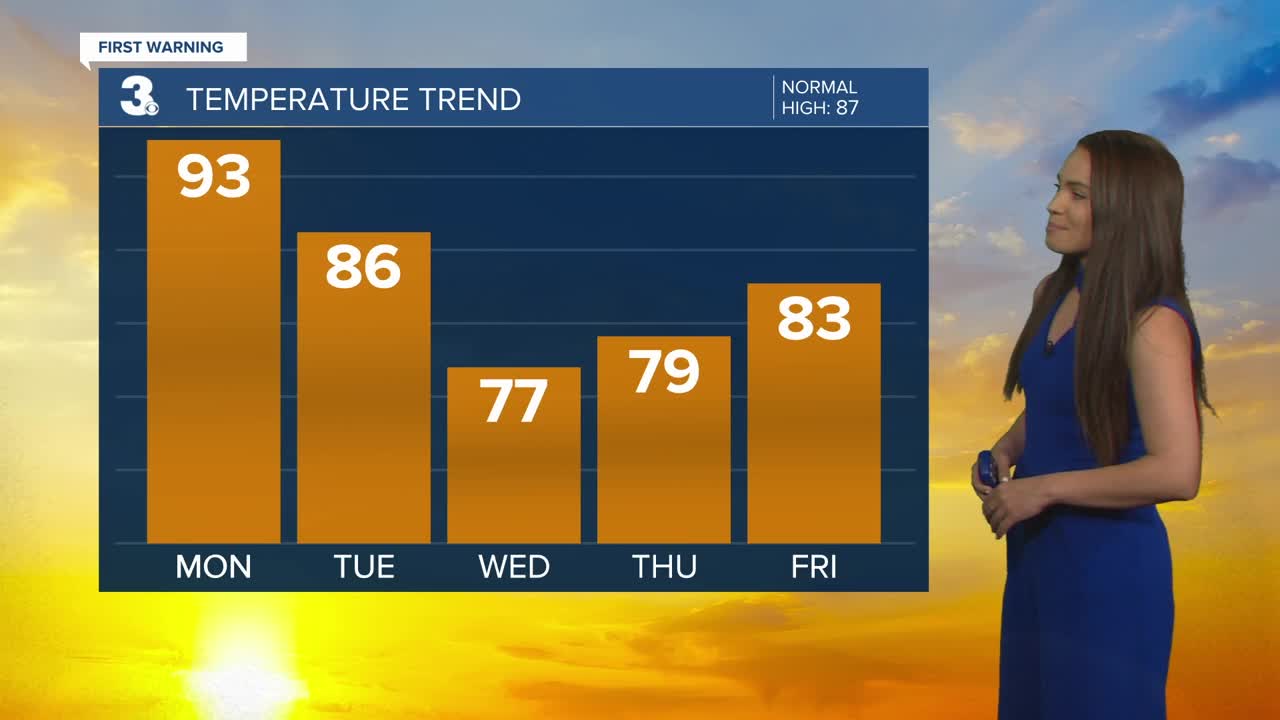
Conditions continue to improve with even some sunshine breaking out. It will be a hot and humid one, with highs in the low 90s.
A cold front will move through Tuesday bringing more showers and storms, especially during the afternoon and evening (2 PM to 7 PM). Some storms could be strong to severe. The Storm Prediction Center has the area under a level 1 for severe storms. The biggest threat will be damaging wind gusts and heavy rainfall. Temperatures will warm to the mid 80s.
Much drier and cooler behind the cold front. High temperatures on Wednesday will struggle to get out of the 70s.
Another dry day on Thursday. Expect mostly sunny skies and highs near 80 degrees.
Tropical Update:
Claudette is centered about 90 miles S of Ocean City, Maryland and about 330 miles SSW of Montauk Point, New York and moving ENE at 28 mph.
On the forecast track, the system will move over the Atlantic Ocean later this morning and pass just south of Nova Scotia on Tuesday.
Maximum sustained winds near 40 mph with higher gusts. These winds are occurring mostly over water, southeast of Claudette's center. Some additional strengthening is possible over the western Atlantic Ocean today. Claudette is forecast to become a post-tropical cyclone Tuesday afternoon and dissipate late Tuesday night.
Tropical-storm-force winds extend outward up to 140 miles from the center in the southeast quadrant.
Weather & Health

Pollen: Low- Medium (Grasses)
UV Index: 4 (Moderate)
Air Quality: Moderate (Code Yellow)
Mosquitoes: Very High
Meteorologist April Loveland
For weather updates on Facebook: HERE
Follow me on Twitter: HERE
Follow me on Instagram HERE
Check out the Interactive Radar on WTKR.com: Interactive Radar
