


Meteorologist Myles Henderson’s First Warning Forecast
***Tropical Storm Warning for Virginia Beach, Chesapeake, Norfolk, Portsmouth, Suffolk, Hampton, Poquoson, Newport News, York, Mathews, Gloucester, Middlesex, Accomack, Northampton (VA), Dare, Currituck, Camden, Pasquotank, Perquimans, Chowan, Gates, Hertford, Bertie. A Tropical Storm Warning means tropical storm-force winds (39+ mph) are expected within this area within the next 36 hours.
*** Tornado Watch until 3 PM Thursday for much of eastern NC, including Care County .
*** Flash Flood Watch from Noon Thursday to 2 AM Friday for Isle of Wight, Franklin, Southampton, Surry, Sussex, Hampton, Poquoson, Newport News, York, Williamsburg, James City, Gloucester, Mathews, Middlesex, Accomack, Northampton (NC).
Elsa moving in today… Expect a warm and muggy morning with partly to mostly cloudy skies. Rain from Elsa will move in by midday. Heavy rain will continue this evening and tonight. Most of the area will see 1” to 3” of rainfall with locally higher totals possible, with a risk for flash flooding. Winds will ramp up through the day, reaching 20-30 mph with gusts to 40+ tonight. Strong to severe storms are possible, including a risk for isolated tornadoes. Storm surge flooding is possible for southern facing tributaries.
Rain and wind from Elsa will move out very early Friday morning. We will see partly cloudy skies tomorrow with scattered showers and storms in the afternoon. highs will warm to the low 90s tomorrow.
Highs will linger in the upper 80s this weekend. We will see a nice mix of sun and clouds with an isolated shower/storm possible (20-30% chance). Highs will warm back to the low 90s next week.
Today: Mostly Sunny to Partly Cloudy. Highs in the mid 90s. Winds: SW 5-15
Tonight: Partly Cloudy. Lows in the low 70s. Winds: SW 5-10
Tomorrow: PM Rain, Storms, Windy. Highs in the low 80s. Winds: S 10-20 G30+
Weather & Health
Pollen: Low-Medium (Grasses)
UV Index: 2 (Low)
Air Quality: Good (Code Green)
Mosquitoes: Extreme
Tropical Update
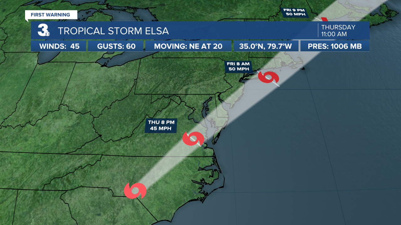
Elsa moves into North Carolina, heavy rain continues. Elsa is centered about 80 miles SW of Raleigh, NC or about 235 miles WSW of Norfolk, VA and moving NE at 20 mph.
On the forecast track, Elsa will move over South Carolina and North Carolina today, pass near the eastern mid-Atlantic states by tonight, and move near or over the northeastern United States on Friday and Friday night. The system should move over Atlantic Canada by Friday night and Saturday.
Maximum sustained winds are near 45 mph with higher gusts. Some strengthening is possible tonight and Friday while the system moves close to the northeastern United States. Elsa is forecast to become a post-tropical cyclone by Friday night.
Tropical-storm-force winds extend outward up to 115 miles from the center.

Weather updates on social media:
Facebook: MylesHendersonWTKR
Twitter: @MHendersonWTKR
Instagram: @MylesHendersonWTKR
