


Meteorologist Myles Henderson’s First Warning Forecast
Typical summer days… We will see a nice mix of sun and clouds today, mostly sunny to partly cloudy skies. Highs will return to the upper 80s this afternoon, but it will feel more like the mid 90s with the humidity. An isolated shower or storm is possible today.
Highs will warm to the low 90s on Monday with an afternoon heat index in the triple digits. We will see mostly sunny to partly cloudy skies with a “pop-up” shower or storms possible. The same pattern continues for Tuesday with highs in the mid 90s and a heat index to 100+.
The leftovers of Hurricane Ida will move over the Mid-Atlantic Wednesday and Thursday. We will see some extra clouds and some scattered showers and storms. Highs will drop to the 80s for the second half of the week.
Today: Sun & Clouds, Isolated Storms. Highs in the upper 80s. Winds: N 5-10
Tonight: Partly Cloudy. Lows in the mid 70s. Winds: S 5-10
Tomorrow: Sun & Clouds, Isolated Storms. Highs in the low 90s. Winds: S 5-10
Weather & Health
Pollen: Medium-High (Ragweed, Grasses)
UV Index: 8 (Very High)
Air Quality: Moderate (Code Yellow)
Mosquitoes: Extreme
Tropical Update
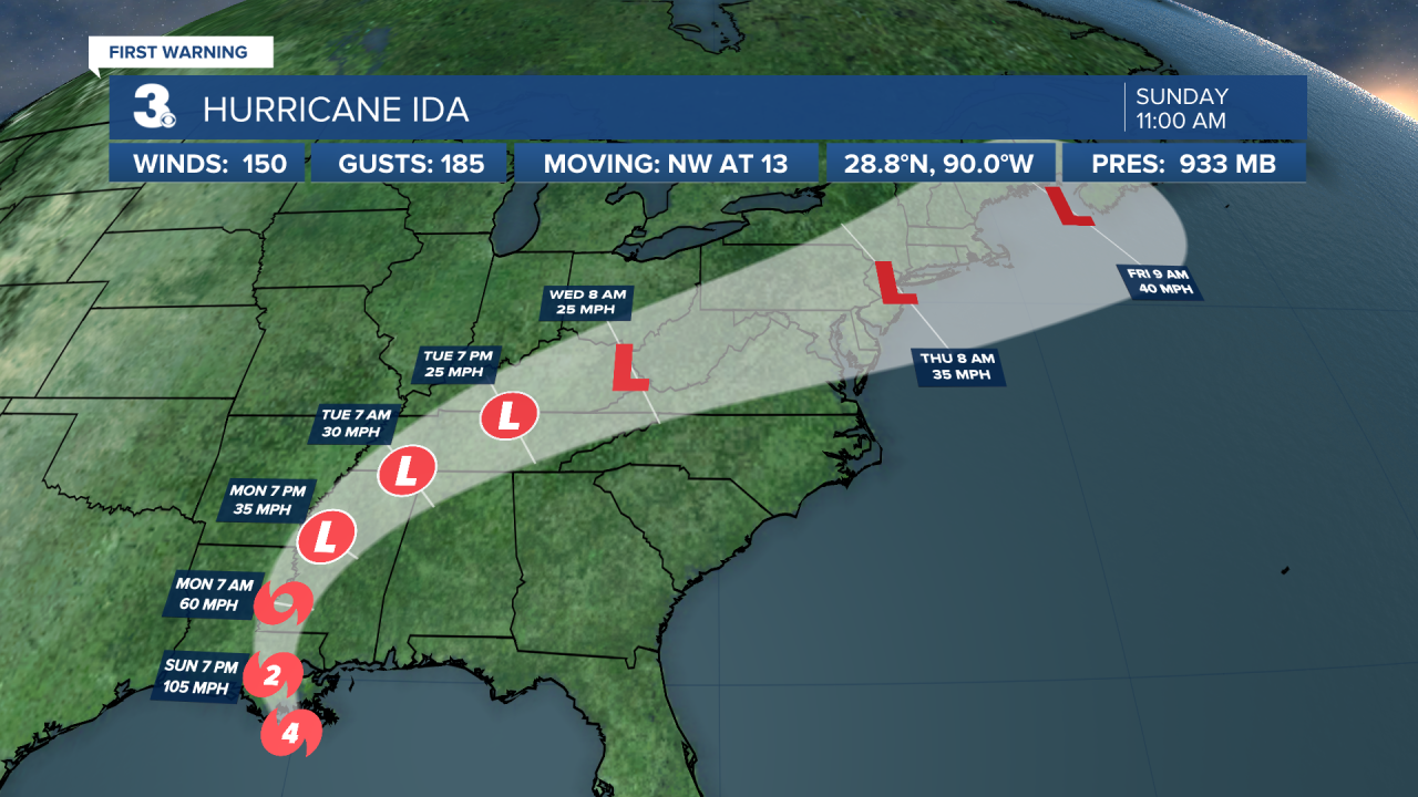
Eye of extremely dangerous category 4 Hurricane Ida nearing the southeastern coast of Louisiana. Catastrophic storm surge and hurricane-force winds moving onshore. Ida is centered about 85 miles south of New Orleans and moving NW at 13 mph.
On the forecast track, the center of Ida will make landfall along the coast of southeastern Louisiana within the next few hours. Ida is then forecast to move well inland over portions of Louisiana and western Mississippi Monday and Monday night and move across the Tennessee Valley on Tuesday.
Reports from NOAA and Air Force Reserve Hurricane Hunter aircraft indicated that the maximum sustained winds are near 150 mph with higher gusts. Ida is an extremely dangerous category 4 hurricane on the Saffir-Simpson Hurricane Wind Scale. Some slight additional strengthening is still possible before Ida moves onshore along the Louisiana coast. Rapid weakening is expected after landfall.
Hurricane-force winds extend outward up to 50 miles from the center and tropical-storm-force winds extend outward up to 150 miles.
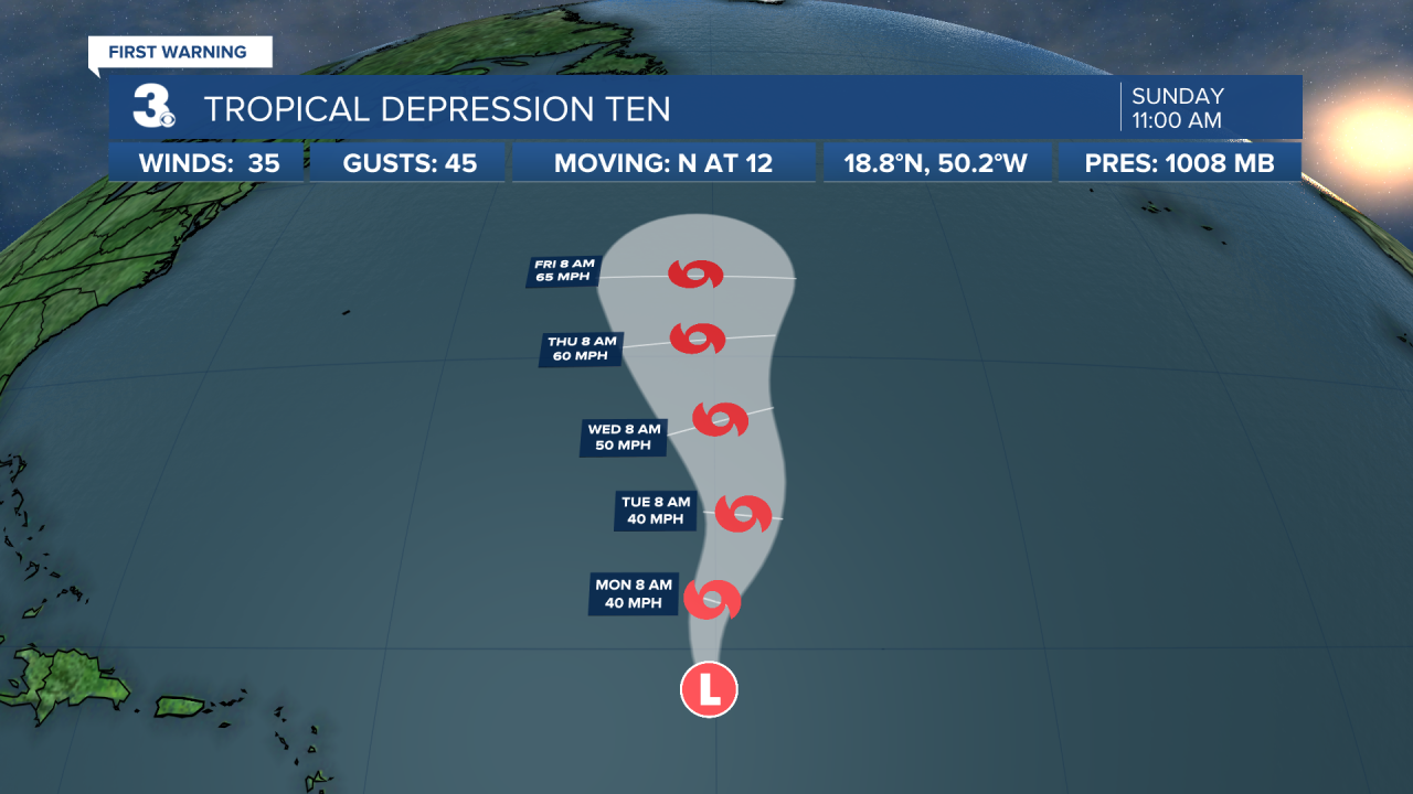
Tropical Depression Ten moving north over the central tropical Atlantic. TD 10 is about 770 miles east of the Leeward Islands and moving north at 12 mph. A motion toward the north or NNE at a slower forward speed is expected through Wednesday, keeping the depression over the central Atlantic during the upcoming week. Maximum sustained winds are near 35 mph with higher gusts. Little change in strength is forecast during the next couple of days, but the depression could become a tropical storm by Tuesday or Wednesday.
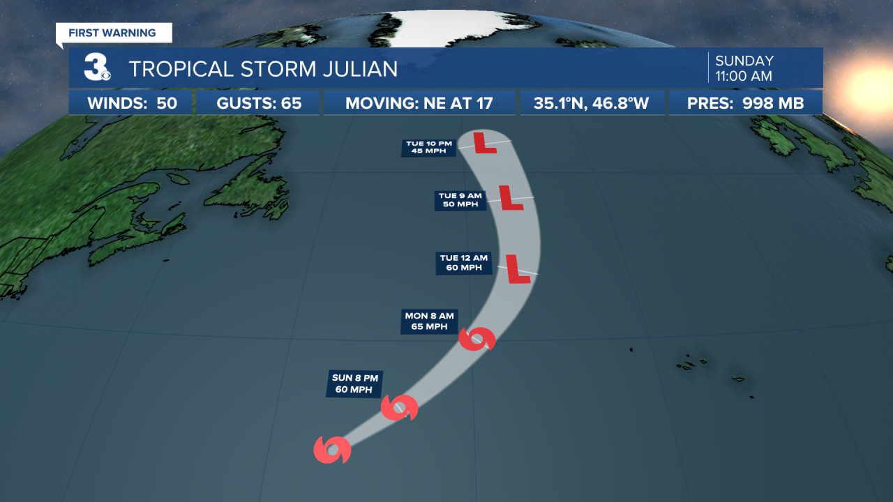
Tropical Storm Julian forms over the central subtropical Atlantic. Julian is centered about 865 miles SSE of Cape Race, Newfoundland and moving NE at 17 mph. A faster motion toward the NE and then north over the north Atlantic is expected through Tuesday. Satellite-derived wind data indicate that maximum sustained winds have increased to near 50 mph with higher gusts. Some additional strengthening is anticipated through tonight. Weakening should begin on Monday, with Julian likely becoming post-tropical by Monday evening.
A tropical wave is expected to emerge off the coast of west Africa by Tuesday. Environmental conditions appear conducive for development once the wave moves offshore, and a tropical depression is likely to form toward the end of the week while the system moves WNW at 10 to 15 mph over the eastern tropical Atlantic.
* Formation chance through 48 hours: Low (20%)
* Formation chance through 5 days: High (80%)
Weather updates on social media:
Facebook: MylesHendersonWTKR
Twitter: @MHendersonWTKR
Instagram: @MylesHendersonWTKR
