


Meteorologist Myles Henderson’s First Warning Forecast
A summer start to the work week… Highs will climb to the low 90s today, about 5 degrees above normal for this time of year. It will feel more like 100 this afternoon with the humidity. Expect partly cloudy skies with scattered showers and storms firing up this afternoon.
Highs will return to the low 90s Tuesday with an afternoon heat index of 100 to 105. Expect a mix of sun and clouds with an isolated shower or storm possible.
The leftovers of Hurricane Ida will move over the Mid-Atlantic Wednesday and Thursday. We will see extra clouds, scattered showers and storms, and breezy conditions. Highs will drop from the upper 80s on Wednesday to the low 80s on Thursday.
The end of the week looks very nice! Expect mostly sunny skies with highs in the low 80s and lower humidity.
Today: Partly Cloudy, Afternoon Storms. Highs in the low 90s. Winds: W/N/S 5-10
Tonight: Partly Cloudy. Lows in the mid 70s. Winds: SW 5-10
Tomorrow: Partly Cloudy, Isolated Storms. Highs in the low 90s. Winds: W/S 5-10
Weather & Health
Pollen: Medium-High (Ragweed, Grasses)
UV Index: 8 (Very High)
Air Quality: Moderate (Code Yellow)
Mosquitoes: Extreme
Tropical Update
Tropical Storm Ida is moving northward over southwestern Mississippi.
Located about 65 miles SSW of Jackson, Mississippi.
Max sustained winds: 45 mph
Ida is moving toward the north near 8 mph and this general motion is forecast to continue today. A faster northeastward motion is expected to begin by tonight and continue on Tuesday.
On the forecast track, the center of Ida will move farther inland over southwestern Mississippi this morning. Ida is then forecast to move over central and northeastern Mississippi this afternoon and tonight, and move across the Tennessee Valley on Tuesday.
Additional rapid weakening is forecast during the next day or so, and Ida is expected to become a tropical depression this afternoon.
Tropical-storm-force winds extend outward up to 150 miles,mainly southeast of the center over water.

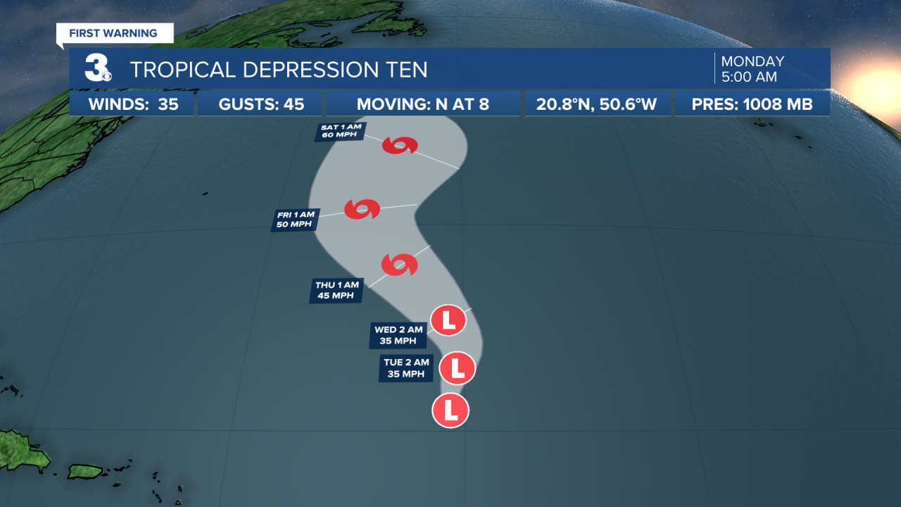
Tropical Depression Ten is centered about 775 miles ENE of the Leeward Islands and moving north at 8 mph. A general northward motion is forecast to continue through Monday followed by a gradual turn toward the northwest by Wednesday. Maximum sustained winds remain near 35 mph with higher gusts. Little change in strength is forecast during the next couple of days. Slow strengthening is forecast to begin in the latter part of this week.
Julian becomes an extratropical cyclone over the north-central Atlantic. A general north to NE motion will continue for the next few days. Maximum sustained winds are near 60 mph with higher gusts. Little change in strength is expected through tonight.
A tropical wave is expected to emerge off the west coast of Africa later today. Environmental conditions appear conducive for the development of a low pressure area once the wave moves offshore, and a tropical depression is likely to form by the middle or latter part of the week while the system moves WNW at 10 to 15 mph over the eastern tropical Atlantic.
* Formation chance through 48 hours: Medium (60%)
* Formation chance through 5 days: High (80%)
Weather updates on social media:
Facebook: MylesHendersonWTKR
Twitter: @MHendersonWTKR
Instagram: @MylesHendersonWTKR
