


Meteorologist Myles Henderson’s First Warning Forecast
Another hot and humid day… Highs will return to the low and mid 90s today with an afternoon heat index of 100 to 105. Expect a mix of sun and clouds with more sun in the morning and more clouds in the afternoon. An isolated shower or storm is possible.
The leftovers of Hurricane Ida will move over the Mid-Atlantic Wednesday and Thursday. We will see extra clouds, scattered showers and storms, and breezy conditions. The biggest chance for rain and storms will be Wednesday night to early Thursday morning. Expect winds at 10 to 20 with gusts to 30 mph. Temperatures will drop from the near 90 on Wednesday to the upper 70s on Thursday.
The end of the week looks very nice! Expect mostly sunny skies with highs in the upper 70s and lower humidity. We will warm back to the low and mid 80s this weekend.
Today: Partly Cloudy, Isolated Shower/Storm. Highs in the low 90s. Winds: W 5-10
Tonight: Mostly Cloudy. Lows in the mid 70s. Winds: S 5-10
Tomorrow: Mostly Cloudy, Showers/Storms. Highs near 90. Winds: S 10-20G30
Weather & Health
Pollen: Medium-High (Ragweed, Grasses)
UV Index: 8 (Very High)
Air Quality: Good (Code Green)
Mosquitoes: Extreme
Tropical Update
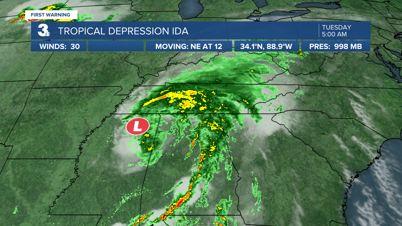
Tropical Depression Ida is centered over northern Mississippi. Ida is expected to continue gradually accelerating to the northeast over the next couple days. Maximum sustained winds are near 30 mph with higher gusts. Little change in strength is forecast during the next 48 hours.
Tropical Storm Kate moving slowly over the central Atlantic. Kate is centered about 815 miles ENE of the Leeward Islands and moving north at 5 mph. A NW motion is forecast to begin tonight and continue into Wednesday. Maximum sustained winds are near 40 mph with higher gusts. Little change in strength is forecast during the next few days.
A well-defined low pressure system is located over the far eastern tropical Atlantic more than 200 miles southwest of the coast of Guinea. Associated shower and thunderstorm activity is beginning to show some signs of organization, and environmental conditions are conducive for additional development of this system. A tropical depression is likely to form during the next day or so while the low moves west to WNW at 10 to 15 mph.
* Formation chance through 48 hours: High (90%)
* Formation chance through 5 days: High (90%)
Weather updates on social media:
Facebook: MylesHendersonWTKR
Twitter: @MHendersonWTKR
Instagram: @MylesHendersonWTKR
