


Meteorologist April Loveland's First Warning Forecast
Still looking mostly dry today with highs in the low 80s but expect more cloud cover. Keeping a slight chance for isolated showers.
A strong cold front will move in on Wednesday with a chance of showers. Highs will once again be in the low 80s. It will feel warmer due to an increase in the humidity. Even though Fall arrives at 3:21 PM, it won't feel very fall-like just yet. Showers will continue overnight and into the day Thursday. Storms will also be possible. Strong to severe storms will be possible. The Storm Prediction Center has a portion of the are until a level 1 for severe storms. The biggest threat will be damaging wind gusts. Thursday will be a bit breezy with highs only in the upper 70s and falling humidity.
Very fall-like to end the work week as drier air works into the area. Highs will reach the mid 70s with dewpoints in the 50s.
Tracking a gorgeous weekend on tap with highs in the mid and upper 70s. Expect mostly sunny skies and dry weather.
Tropical Update
Peter is moving toward the west-northwest near 9 mph. A west-northwest motion is expected to continue today. A turn to the north with a decrease in forward speed is expected beginning tomorrow. On the forecast track, the center of Peter is currently passing north of the Virgin Islands and Puerto Rico today and should move well east of the southeastern Bahamas during the next few days. Maximum sustained winds have decreased to near 40 mph with higher gusts. Additional weakening is forecast over the next several days. Peter is expected to weaken to a tropical depression by tonight and then degenerate to a remnant low by Thursday. Tropical-storm-force winds extend outward up to 150 miles from the center.

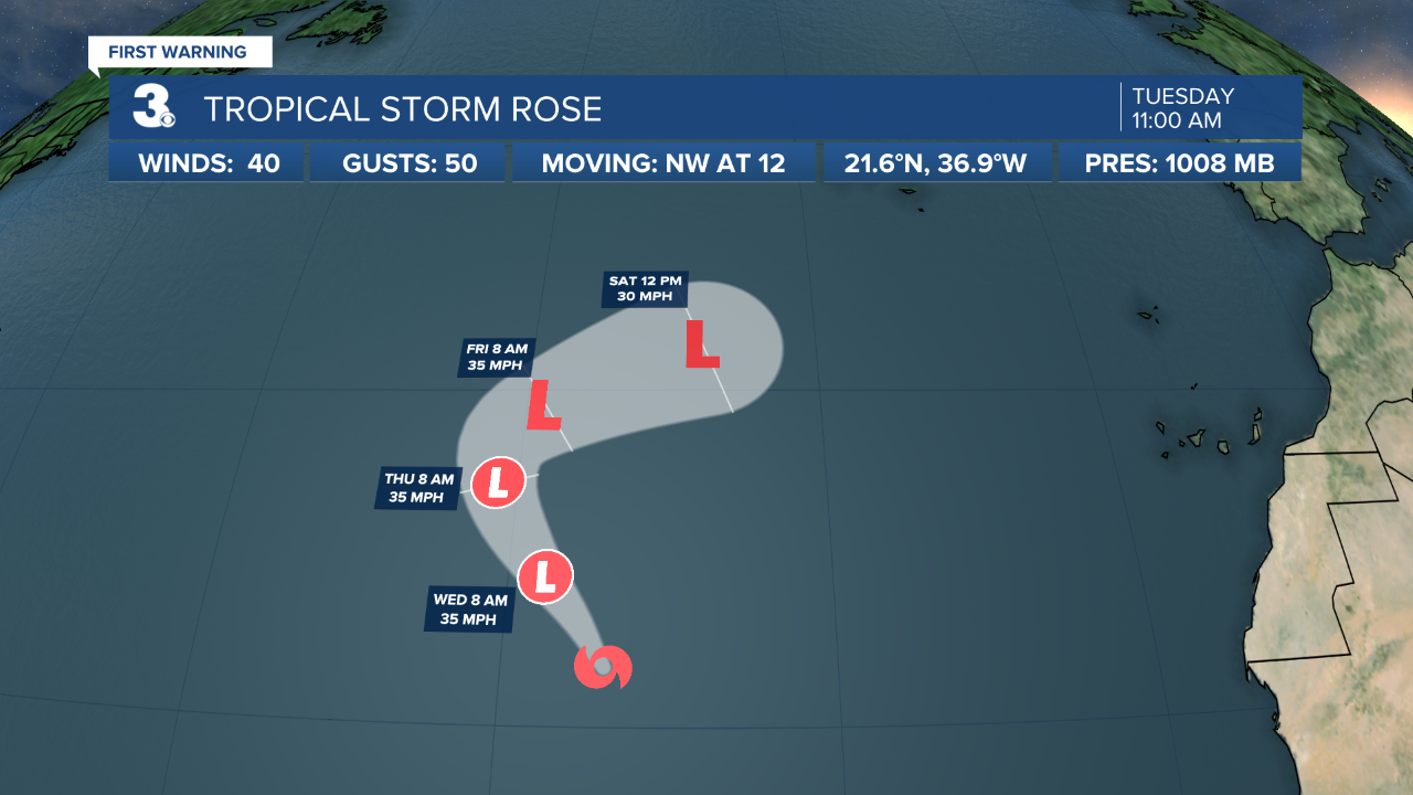
Rose is moving toward the northwest near 12 mph. The storm should gradually turn toward the north during the next couple of days and move more to the northeast on Friday. Maximum sustained winds have decreased to near 40 mph with higher gusts. Rose could decay into a tropical depression this evening and degenerate into a remnant low by Friday. Tropical-storm-force winds extend outward up to 90 miles from the center.
Meteorologist April Loveland
For weather updates on Facebook: HERE
Follow me on Twitter: HERE
Follow me on Instagram HERE
Check out the Interactive Radar on WTKR.com: Interactive Radar
