


Meteorologist Myles Henderson’s First Warning Forecast
Rain today, sunshine tomorrow… Expect mostly cloudy skies with scattered showers and storms today as a cold front moves through the region. The biggest chance for storms will be this afternoon to early evening. Severe storms are not expected, but heavy downpours are possible. It will be cooler today with highs in the upper 70s, but it will still be muggy.
Friday will be the nicest day of the work week. Highs will return to near 80 with lower humidity and mostly sunny skies. Sunshine will continue for the weekend with temperatures warming to the low 80s on Saturday and the mid 80s on Sunday.
Sunshine will continue for the start of next week with highs in the mid to upper 80s and more humidity.
Today: Mostly Cloudy, Showers/Storms. Highs in the upper 70s. Winds: SW 5-15
Tonight: Evening Showers/Storms, Clearing Late. Lows in the mid 60s. Winds: N 5-15
Tomorrow: Mostly Sunny. Highs near 80. Winds: N 10-15
Weather & Health
Pollen: Low (Ragweed, Grasses)
UV Index: 1 (Low)
Air Quality: Good (Code Green)
Mosquitoes: Extreme
Tropical Update
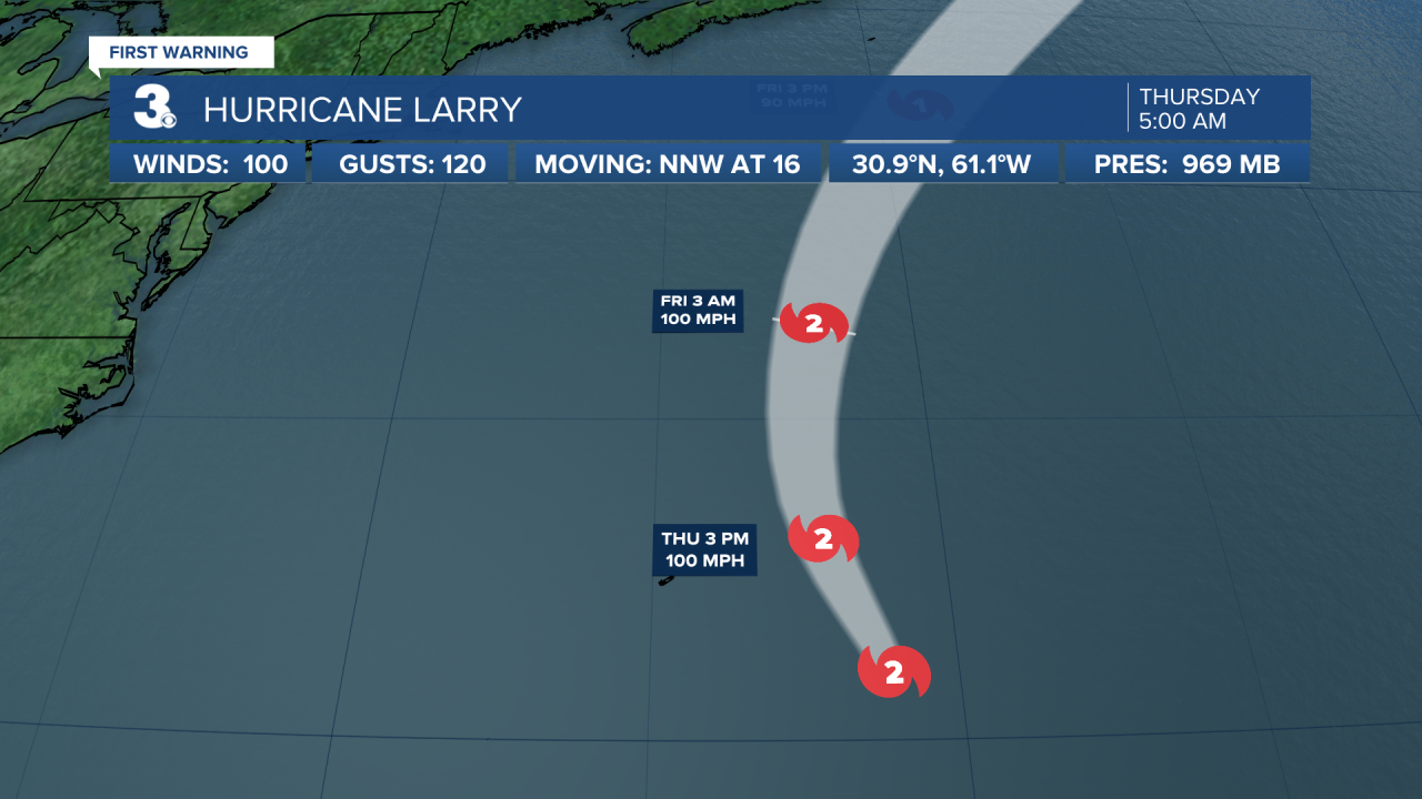
Hurricane Larry’s outer bands approaching Bermuda. Larry is centered about 240 miles ESE of Bermuda and moving NNW at 16 mph. A turn toward the north with an increase in forward speed is forecast today, with a faster NE motion expected by Friday. On the forecast track, the center of Larry should pass east of Bermuda today and move near or over southeastern Newfoundland late Friday. Maximum sustained winds are near 100 mph with higher gusts. Gradual weakening is forecast during the next couple of days, but Larry is expected to remain a hurricane during that time. Larry should become an extratropical cyclone early Saturday, after passing by Newfoundland, then weaken further while it passes southeast of Greenland Sunday night.
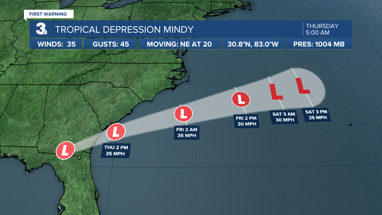
Tropical Depression Mindy is moving over southern Georgia. Mindy is centered about 80 miles SSE of Valdosta, Georgia and moving NE at 20 mph. On the forecast track, the center of Mindy is expected to move across southeastern Georgia this morning, and over the Atlantic by late this morning or early this afternoon. Maximum sustained winds are near 35 mph with higher gusts. Little change in strength is forecast through tonight. Gradual weakening is expected on Friday, and Mindy is forecast to become a remnant low by Saturday.
The northern portion of a tropical wave over the western Caribbean Sea is forecast to emerge over the southern Bay of Campeche on Saturday. Environmental conditions are expected to be conducive to support some gradual development of the system before it moves into mainland Mexico early next week.
* Formation chance through 48 hours: Low (0%)
* Formation chance through 5 days: Low (20%)
A strong tropical wave is expected to emerge off the west coast of Africa on Saturday. Environmental conditions are forecast to be conducive for development thereafter, and a tropical depression could form by early next week as it moves WNW over the far eastern Atlantic near the Cabo Verde Islands.
* Formation chance through 48 hours: Low (0%)
* Formation chance through 5 days: Medium (50%)
Weather updates on social media:
Facebook: MylesHendersonWTKR
Twitter: @MHendersonWTKR
Instagram: @MylesHendersonWTKR
