


Hurricane Erin marks the first hurricane of the 2025 Atlantic season. Although the storm is pulling away, we are still feeling the outside impacts. Tidal flooding will continue into Friday, likely during the morning and evening high tides.
We'll provide updates on Hurricane Erin's movements and impacts on our area in the live blog below:
Friday, Aug. 22, 11 a.m. — Currituck County lifts the evacuation order for the Corolla off-road area.
Currituck County will rescind the local State of Emergency and mandatory evacuation order for the Corolla Off-Road Area on Friday, August 22, 2025, at 12:00 pm. At that time, the 4WD beach driving area will be accessible to the public.
Motorists should use caution at dune access ramps where erosion has occurred, and some sections of the beach driving area may be impassable or have limited driving lanes during high tides.
Corolla Beach Rescue has posted Double Red Flags today for ocean beaches in Currituck County. Water entry is not permitted.
The Carova Beach trash and recycling center will also reopen at 12:00 pm. Trash collection in the paved section of Corolla scheduled for today has been postponed until Monday, August 25, 2025.
Citizens can find updates from Currituck County here.
Watch: Cape Hatteras Motel dealing with sand, flooding damage from Hurricane Erin
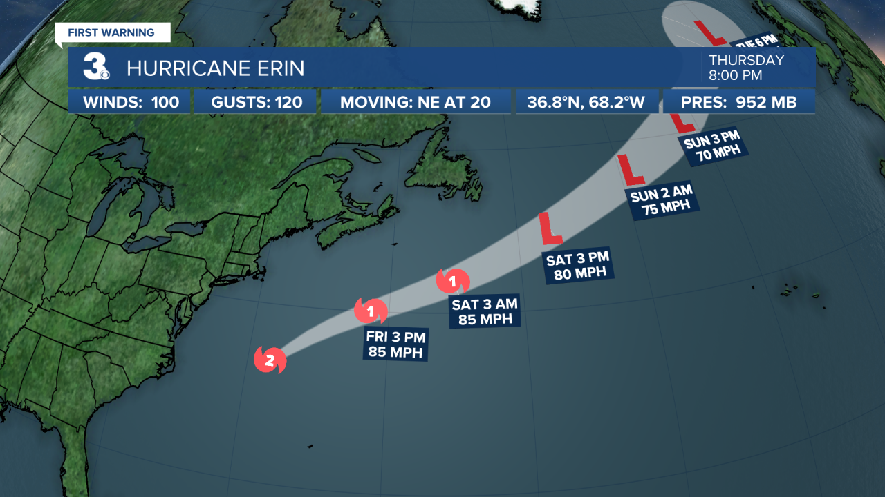
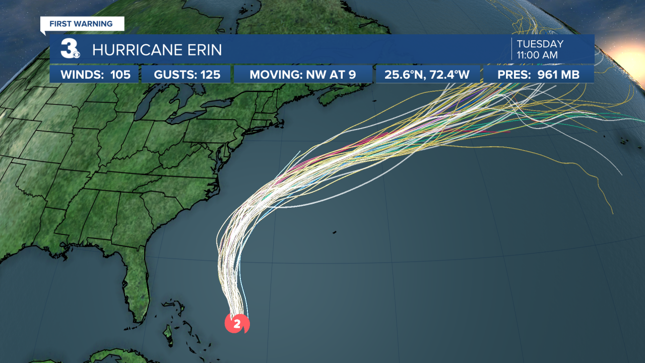
Friday, Aug. 22, 11 a.m. — The center of Hurricane Erin is expected to pass south of Atlantic Canada today — tonight, it will race across the north Atlantic waters.
Hurricane Erin is currently centered about 460 miles NNE of Bermuda.
Friday, Aug. 22, 7:20 a.m. — Two new dune breaches were opened up along NC12 as a result of this morning's high tide cycle, according to NCDOT.
Crews are currently out clearing and rebuilding the impacted areas. NC12 will remain closed at the Marc Basnight Bridge and on the north end of Ocracoke.
Friday, Aug. 22, 5 a.m. — Hurricane Erin is centered about 435 miles north of Bermuda. On the forecast track, the center of Erin will pass south of Atlantic Canada today and tonight and then race across the north Atlantic waters.
Maximum sustained winds are near 90 mph with higher gusts. Erin is likely to become post-tropical by tonight but remain a powerful hurricane-force low pressure system through the weekend.
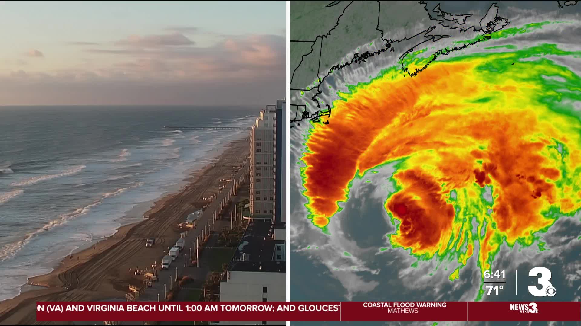
Thursday, Aug. 21, 11:28 p.m. — Hurricane Erin is pulling away from our area at 22 mph. We saw the worst of the tidal flooding Thursday evening, but we can expect some minor to moderate flooding on Friday. The Coastal Flood Warning is still in effect until 5 p.m. on Friday.

Thursday, Aug. 21, 8 p.m. — Hurricane Erin is maintaining its course pulling away from Hampton Roads and the Outer Banks. Erin is still a category 2 hurricane with maximum sustained winds of up to 100 mph. Wind gusts in our region have come down significantly over the last 12 hours, and wind advisories have been canceled across the region.

Tropical Storm Warnings are only in effect over the immediate coastlines, with no more warnings inland or over the sounds. A coastal flood warning is still in effect for Hampton Roads and ESVA until 5 pm tomorrow, and a storm surge warning is still in effect from Hatteras up to Duck on the Outer Banks.
High tide this evening will likely bring some of the worst of the tidal flooding. Moderate flooding is expected in Norfolk, and Lynnhaven Inlet in Virginia Beach is just below major flood stage. Tomorrow, tidal flooding will be likely during the morning and evening high tides, with everything starting to get back to normal by Saturday.
Rip currents will still impact our beaches through Saturday, with conditions improving by Monday.
Watch: Hurricane Erin could cause major flooding during Thursday night's high tide
Thursday, Aug. 21, 4:03 p.m. — Virginia Beach Funk Fest Beach Party performances that were scheduled to go on Friday, Aug. 22 are being relocated to different venues due to storm surge concerns along the beach.
Due to the impact of Hurricane Erin and the expected major storm surge in Virginia Beach on Thursday evening, all preparations for the Virginia Beach Funk Fest Beach Party on the sand — including stage buildout — have been paused until the storm passes.
As a result, Friday, August 22 performances will be relocated to alternate venues. With large crowds expected on Friday evening, two simultaneous shows will take place at 17th and 24th Street Parks, ensuring enough space is available for fans. Large screens will also be placed on the Boardwalk for overflow crowds to enjoy the show from the sand.
Saturday, August 23 performances will take place as planned on the beach, with crews beginning stage construction Friday morning.
Watch: City of Virginia Beach shares video of flooded intersection as Hurricane Erin brushes by East Coast
Thursday, Aug. 21, 3:30 p.m. — The North Carolina Department of Transportation held a press conference to discuss the closure of a portion of N.C. 12 in response to ocean overwash from Hurricane Erin.
Watch: NC 12 on Hatteras Island to remain closed due to overwash from Erin
"N.C. 12 here at the Basnight Bridge is still closed. We are still concerned about the next two high tide cycles, which are tonight at seven and tomorrow morning at 7:30 a.m.," said Tim Hass, the communications officer for NCDOT's Division One and the Ferry Division. "Right now, our crews are out there. They are getting the road in as good a shape as possible to prepare for tonight's high tide."
On Wednesday night, NCDOT closed N.C. 12 south of the Marc Basnight Bridge to Hatteras Village in Dare County, officials said. N.C. 12 is also closed on the north end of Ocracoke Island between the National Park Service Pony Pens and the ferry terminal.
NCDOT said they plan to keep the highway closed until it is considered safe.
"But at this point, it's all about safety, and it's not quite safe to open the road to the public at this point," Hass said. "Well, what needs to happen is we need to stop having to worry about the overwash. That's the problem right now."
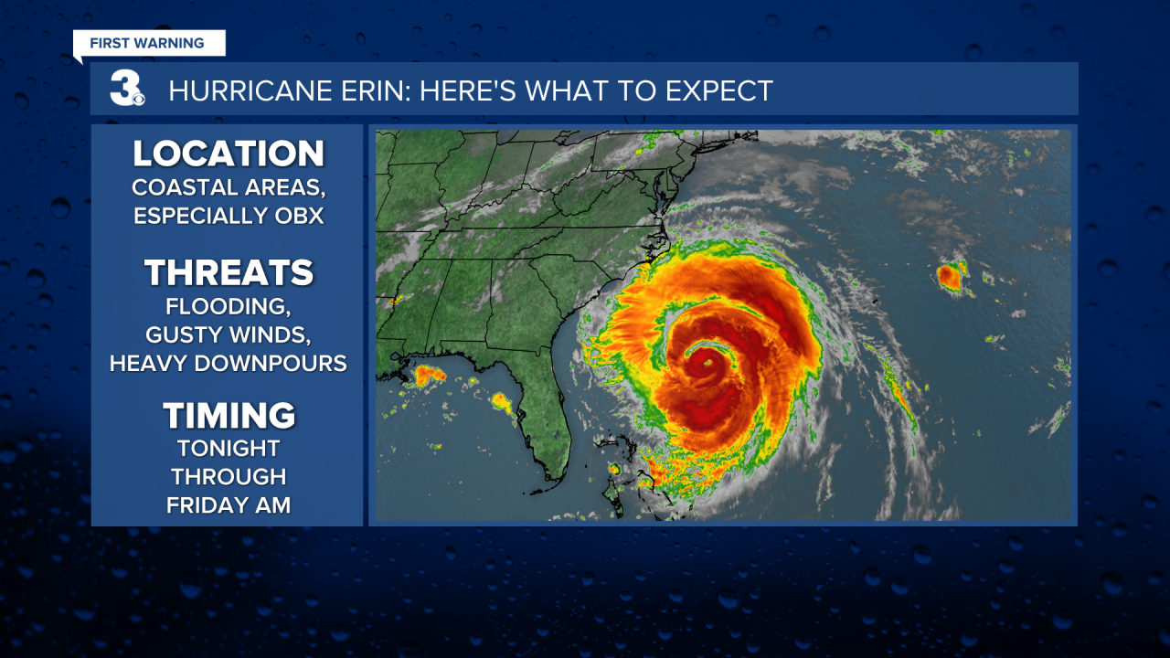
Thursday, Aug. 21, 2 p.m. — Hurricane Erin is now centered about 285 miles away from Cape Hatteras, and is moving NE at 18 mph. Tropical Storm Warning is still in effect for Beaufort Inlet, North Carolina to Chincoteague Virginia, including Pamlico and Albemarle Sound. We still have a storm surge warning in effect for the Outer Banks, and coastal flood warnings are in effect for SE Virginia through Friday.

This evenings high tide will be bring the worst of the coastal flood, and minor to moderate coastal flooding is likely on Friday as well.
Winds will continue to subside, and won't be an issue by tomorrow afternoon.
Thursday, Aug. 21, 12:47 p.m. — The city of Chesapeake is opening a garage at TCC's Chesapeake campus for those worried about flooding.
If your neighborhood is prone to tidal flooding, the parking garage at Tidewater Community College, Chesapeake Campus, located at 1428 Cedar Rd, will accept vehicles.
Tidal flooding is expected to be at its highest around 11:00 p.m. tonight so if you have to be out, be alert to standing water and remember – turn around, don’t drown!
Thursday, Aug. 21, 11 a.m. — Hurricane Erin is centered about 260 miles east of Cape Hatteras, NC. A Tropical Storm Warning is in effect from Beaufort Inlet, NC to Chincoteague, VA including the Albemarle and Pamlico Sounds. A Storm Surge Warning is in effect for Cape Lookout to Duck, NC.

A faster NE to ENE motion is expected during the next couple of days. On the forecast track, the center of Erin will move over the western Atlantic between the U.S. east coast and Bermuda through early Friday, and then pass south of Atlantic Canada Friday and Saturday.
Maximum sustained winds are near 100 mph with higher gusts. Gradual weakening is forecast during the next couple of days. Erin is expected to become post-tropical on Saturday.
Erin is a very large hurricane. Hurricane-force winds extend outward up to 105 miles from the center and tropical-storm-force winds extend outward up to 320 miles.

Thursday, Aug. 21 10:30 a.m. — The Elizabeth River Ferry is back on its regular schedule. Service was previously suspended around 10 a.m. due to high winds and flooding.
Effective 10:30 A.M., all ferry operations will resume regular service. Passengers may return to regular boarding at the ferry docks. For more information, please visit gohrt.com or call 757-222-6100.
Thursday, Aug. 21, 8 a.m. — Hurricane Erin is expected to turn NE later today with a coinciding increase in its forward speed.
The Category 2 storm is centered about 210 miles east of Cape Hatteras. A Tropical Storm Warning is still in effect from Beaufort Inlet, NC to Chincoteague, VA including the Albemarle and Pamlico Sounds. A Storm Surge Warning is in effect for Cape Lookout to Duck, NC.
Thursday, Aug. 21, 7:30 a.m. — In Norfolk, water has begun creeping onto roads and into neighborhoods.
Below is a photo taken in the Larchmont neighborhood, showing the tide making its way towards backyards in the area.

Thursday, Aug. 21, 6:17 a.m. — No swim advisory signs were put up across the Virginia Beach Oceanfront as Hurricane Erin nears our stretch of the east coast Thursday morning.
News 3's Virginia Beach Reporter John Hood was pelted by heavy winds as he discussed the conditions at the Oceanfront. Strong waves and extreme rip currents were seen along the coastline.
Thursday, Aug. 21, 6:05 a.m. — In Nags Head, NC, News 3's Colter Anstaett says no rain has fallen yet, but gusty winds have certainly arrived.
The News 3 van was shaking as a result of the powerful winds. Meteorologist Myles Henderson says wind gusts in the Outer Banks could pass 50 miles per hour during the early hours of Thursday morning.
Thursday, Aug. 21, 5 a.m. — Hurricane Erin — which is still a Category 2 storm — is centered about 205 miles ESE of Cape Hatteras, NC.
A Tropical Storm Warning is in effect from Beaufort Inlet, NC to Chincoteague, VA including the Albemarle and Pamlico Sounds. A Storm Surge Warning is in effect for Cape Lookout to Duck, NC.
Maximum sustained winds are near 105 mph with higher gusts. Gradual weakening is forecast during the next couple of days. Erin is expected to become post-tropical by Saturday.
Wednesday, Aug. 20, 6:30 p.m. — Due to storm surges from Hurricane Erin, N.C. 12 closed from Oregon Inlet to Hatteras Village at 6:30 p.m. on Wednesday, according to the North Carolina Department of Transportation.
NCDOT said conditions are unsafe for drivers in that area and asks if you see any flood waters, turn around and don't drown.
Wednesday, Aug. 20, 5:47 p.m. — Minor to moderate tidal flooding persists this evening with mostly cloudy skies and a few spotty showers associated with a frontal boundary, says Forecaster Derrah Getter.
Erin will stay offshore so it won't be a huge rain maker for us but it will cause major flooding concerns.
The primary threats will be along the Outer Banks where periods of tropical downpours, strong wind and especially ocean over wash will take place. Storm surge can reach up to 5 ft along the immediate coast with wave heights up to 14 ft. Storm effects subside Friday morning with bright sunshine returning to the forecast through the weekend.
Wednesday, Aug. 20, 5:16 p.m. — The NC-Virginia coast will likely see the worst of impacts from Hurricane Erin on Thursday from midnight to 8 a.m., especially in the Outer Banks. While the core of the storm will stay over water, Chief Meteorologist David Aldrich says its great tropical storm force winds are far-reaching, posing a threat to coastal areas.
Wednesday, Aug. 20, 4:22 p.m. — A portion of NC 12 is closing for now, per NCDOT: "After the last ferry from Ocracoke departs for Hatteras at 5:30 [Wednesday] afternoon, NC12 will be CLOSED until further notice on the north end of Ocracoke Island between the Pony Pens and the Ferry Terminal. We will reopen the road as soon as it is safe to do so."
Wednesday, Aug. 20, 4:19 p.m. — Portsmouth is opening three city garages amid flooding concerns as Hurricane Erin continues heading north.
The following garages will be open from 5 p.m. on Wednesday, Aug. 20 until noon on Friday, Aug. 22:
- Middle Street Garage - 2nd Floor and Above
- Water Street Garage
- County Street Surface Parking Lot
Wednesday, Aug. 20, 4 p.m. — PETA offers tips & warnings on what to do with your pets during a hurricane:
- Keep all animals indoors with you if you choose not to evacuate. Never leave them tethered, penned, or crated or outside to fend for themselves.
- If you evacuate, plan your destination in advance and do not leave animals behind or unsupervised in a car.
- A hurricane of this intensity can be very dangerous for people residing on boats. Please consider evacuating and always bring your animals with you.
- Be prepared: Use secure carriers, leashes, and harnesses. Bring along water and food bowls, a favorite toy, a blanket, a towel, and enough food for a week. Have your animals microchipped, and put secure, legible ID tags on them.
- Watch for other animals in trouble. If you see any animals in distress and can’t help, note their location and call authorities immediately.
Wednesday, Aug. 20, 3 p.m. — Hurricane Erin is continuing her trek north. We now have a coastal flood warning in effect for the 7 cities, and a wind advisory is in effect for inland counties/cities as well.
Winds from Hurricane Erin are forecast to pick up around midnight on Thursday or an hour or two earlier, Chief Meteorologist David Aldrich says. Those winds are expected to be the most intense from midnight to around 8 a.m.

Wednesday, Aug. 20, 2:54 p.m. — The National Weather Service issued a Coastal Flood Warning for the following areas of Virginia: Charles City, Surry, James City, Isle of Wight, Norfolk, Portsmouth, York, Newport News, Hampton/Poquoson Counties, Suffolk and Chesapeake.
The weather service said the warning will go into effect on Friday from 7 a.m. to 5 p.m., due to flooding expected to reach one to three feet above ground level in low-lying areas near shorelines and tidal waterways.
The flooding may lead to numerous road closures and shoreline erosion, the weather service detailed. Low-lying property, such as homes, businesses and critical infrastructure, may be inundated.
Wednesday, Aug. 20, 11:30 a.m. — Norfolk will open the York Street Garage beginning Wednesday at 4 p.m. for residents who need to move their vehicles to higher ground. That garage will remain open until 8 a.m. on Saturday, Aug. 23.
Wednesday, Aug. 20, 11 a.m. — Hurricane Erin is centered about 365 miles SSE of Cape Hatteras, NC. A Tropical Storm Warning is in effect from Beaufort Inlet, NC to Chincoteague, VA including the Albemarle and Pamlico Sounds. A Storm Surge Warning is in effect for Cape Lookout to Duck, NC.
A turn toward the NNE is expected later today and tonight, followed by a faster motion toward the NE and ENE by Thursday and Friday. On the forecast track, the center of Erin will move over the western Atlantic between the U.S. east coast and Bermuda today through early Friday and then pass south of Atlantic Canada Friday and Saturday.
Maximum sustained winds have increased to near 110 mph with higher gusts. Some additional strengthening is likely during the next day or so, and Erin could become a major hurricane again by tonight. Weakening is likely to begin by Friday, but Erin is forecast to remain a hurricane into the weekend.
Erin is a large hurricane. Hurricane-force winds extend outward up to 90 miles from the center and tropical-storm-force winds extend outward up to 265 miles.
Wednesday, Aug. 20, 10 a.m. — North Carolina Governor Josh Stein says Hurricane Erin is poised to make its closest approach to the state around late Wednesday and into Thursday, prompting officials to put preparations in place ahead of the storm's impact.
Officials expect the storm to strengthen over the course of Wednesday as it makes its way north, Gov. Stein shared during a briefing Wednesday morning. He stressed that while all residents need to take caution, those along the coast will likely see the worst of the storm.
"We are anticipating coastal flooding from massive waves, tropical storm force winds and tidal and storm surge for much of the state shoreline, especially the Outer Banks," said Gov. Stein.

Wednesday, Aug. 20, 8 a.m. — Hurricane Erin is centered about 400 miles SSE of Cape Hatteras, NC.
Erin is a large hurricane and growing. Hurricane-force winds extend outward up to 90 miles from the center and tropical-storm-force winds extend outward up to 265 miles.
Wednesday, Aug. 20, 6:20 a.m. — The winds brought in by Hurricane Erin brings the possibility for sound side flooding late Thursday night and possibly into Friday morning, according to a presentation given by the National Weather Service (NWS) in Newport/Morehead City, NC.
A Tropical Storm Warning was issued for areas across the Chesapeake Bay. This includes Windmill Point, Newport Comfort. The warning also applies to the James River from the James River Bridge to the Hampton Roads Bridge-Tunnel
NWS says the highest water levels are expected to be on oceanside areas through Friday. Severe beach and coastal damage is expected amid forecasts of large waves in the area.
Wednesday, Aug. 20, 5 a.m. — A Tropical Storm Warning is in effect from Beaufort Inlet to the NC/VA border including the Albemarle and Pamlico Sounds. A Tropical Storm Watch is in effect from the NC/VA border to Chincoteague, VA. A Storm Surge Warning is in effect for Cape Lookout to Duck, NC.
Hurricane Erin is centered about 455 miles SSE of Cape Hatteras.
A turn toward the north is expected today, followed by a northeast motion on Thursday. On the forecast track, the center of Erin will move over the western Atlantic between the U.S. east coast and Bermuda today through early Friday and then pass south of Atlantic Canada Friday and Saturday.
Tuesday, Aug. 19, 8:44 p.m. — Currituck County officials declared a mandatory evacuation order for the Off-Road Area of Corolla, starting at 9 a.m. on Wednesday, in response to Hurricane Erin.
The Off-Road Area of Corolla is under a local state of emergency, officials said.
Storm surges and coastal flooding from Erin are expected to impact the area, officials stated. By Thursday afternoon, the beach strand driving area, the only entry and exit point for drivers in the Off-Road Area, will be impassable.
Neighborhoods behind the dunes are expected to experience flooding, officials said.
Anyone in need of evacuation assistance is asked to call Currituck County Emergency Management at 252-232-2115.
Tuesday, Aug. 19, 5:35 p.m. — Dominion Energy crews are prepared to work around the clock as Hurricane Erin moves closer to our area.
Officials with Dominion Energy said that they have been monitoring the storm for over a week and expect most power outages to occur on Thursday.
Crews are working to reinforce power poles as well as stockpiling equipment in Kitty Hawk, officials stated.
These preparations also take into account the potential flooding from the storm, which will soak the ground and cause trees to fall, damaging power poles and lines, officials said.
Crews are focused on the wind gusts in the coastal regions, specifically Virginia Beach, the Outer Banks, eastern Elizabeth City and the Williamston area, officials shared. They are also monitoring the impacts on Norfolk, Chesapeake, the Peninsula, and the Gloucester area.
Crews with specialized equipment are prepared for whatever comes their way.
Tuesday, Aug. 19, 4:36 p.m. — Hurricane Erin remains a Category 2 hurricane and continues to move north. Erin is expected to remain a Category 2 hurricane as it passes to our east on Thursday. Tropical Storm Warnings are in effect up and down the Outer Banks, with Tropical Storm Watches surrounding them.

Hurricane Erin will move out over the Northern Atlantic on Friday and continue to weaken into the weekend.

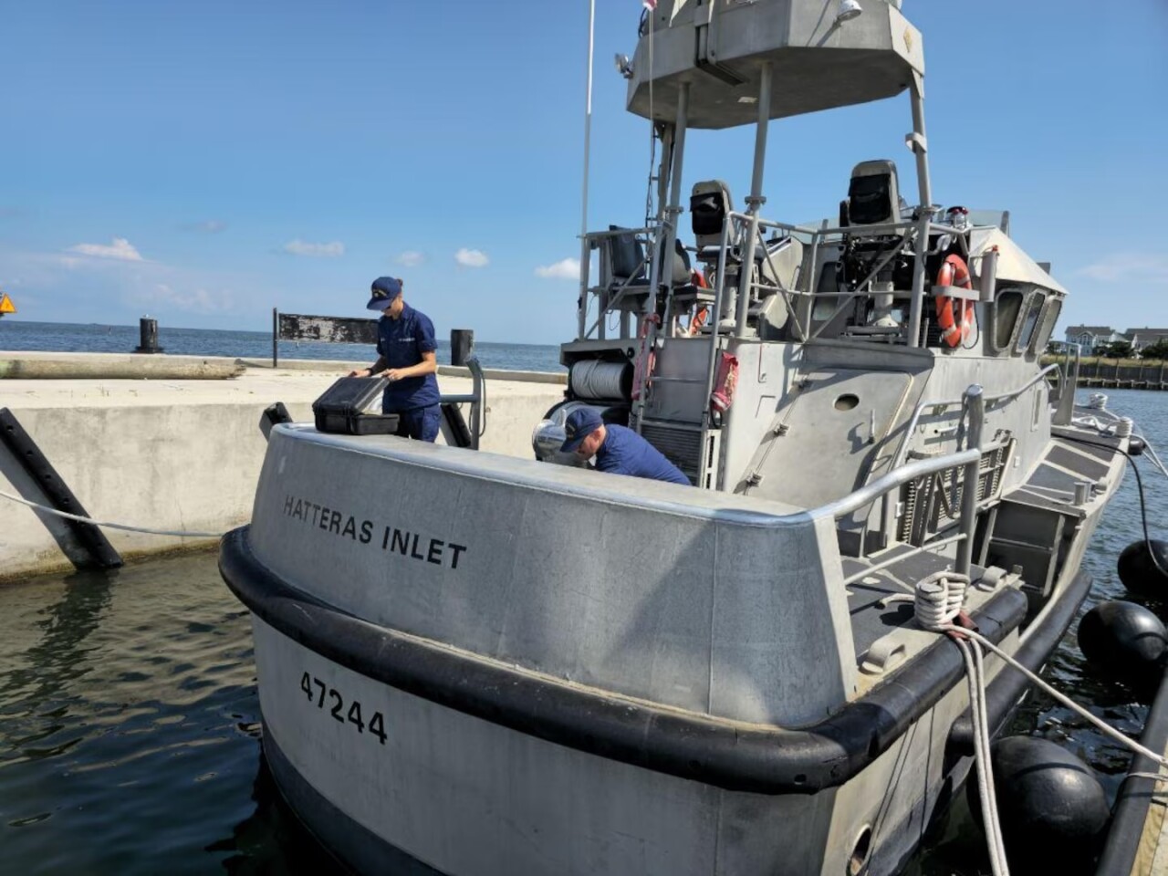
Tuesday, Aug. 19, 4:04 p.m. — Coast Guard East District units give an update on their preparations for Hurricane Erin: "Aircrews, cutters, boat crews, and command centers across the region are actively staging and preparing to respond to any potential impacts from the storm."
Tuesday, Aug. 19, 2:53 p.m. — Crews with the North Carolina Department of Transportation were working to fortify sand walls on the beaches along NC12 — notorious for flooding to the point of being impassable. But, they said, "it likely won't be enough" based on the forecast.

Tuesday, Aug. 19 — North Carolina Gov. Josh Stein declares a state of emergency, telling residents to make "final preparations along the coast." He says officials are getting resources and personnel together to help along the coast.
Tuesday, Aug. 19, 12 p.m. — All vacationers in Currituck's 4WD area have been advised to leave the area ahead of Hurricane Erin's arrival. A state of emergency has not been issued for Currituck County as of Tuesday at noon.
Currituck County says the 4WD beach road will likely become impassable on Aug. 21.
Full-time residents can contact Currituck County Emergency Management at 252-232-2115 if assistance is needed.
Tuesday, Aug. 19, 11 a.m. — A Tropical Storm Warning is in effect from Beaufort Inlet to Duck, North Carolina including the Pamlico Sound. A Storm Surge Warning is in effect for Cape Lookout to Duck.
Hurricane Erin's path continues, with it being centered about 690 miles SSE of Cape Hatteras.
On the forecast track, the center of Erin will pass to the east of the Bahamas today and tonight and then move over the western Atlantic between the U.S. east coast and Bermuda on Wednesday and Thursday.
Tuesday, Aug. 19, 10:14 a.m. — Immediate closures across the Assateague National Seashore were announced by the National Park Service.
The Oversand Vehicle Areas and all Oceanside Beaches will be closed due to Hurricane Erin's arrival. Flooding, beach erosion, and extreme rip current conditions were cited as the reasons for these closures.
Parking lots at the Chicnoteague Beach will be partially closed — however, a full closure of these parking lots is expected, according to the National Park Service.
More closures are possible, they are contingent on the Hurricane Erin's coinciding wind speeds and tidal surge.
Tuesday, Aug. 19, 9 a.m. — The North Carolina Department of Transportation's Facebook page for N.C. 12 posted about "some minor ocean trickle" making its way to Buxton and Ocracoke Island ahead of Hurricane Erin's arrival.
The social media page urged visitors and residents to follow the mandatory evacuation orders for both Dare and Hyde County.
Tuesday, Aug. 19, 8 a.m. — Hurricane Erin, currently a category 2 storm, is now 720 miles SSE of Cape Hatteras.
Meteorologist Myles Henderson says maximum sustained winds are near 110 mph with higher gusts. Fluctuations in strength are possible over the next few days. Hurricane-force winds are expected to extend outward up to 80 miles from the center and tropical-storm-force winds extend outward up to 205 miles.
Tuesday, Aug. 19, 5 a.m. — A tropical storm watch is in effect from Beaufort Inlet to Duck, North Carolina including the Pamlico Sound.
Hurricane Erin is currently centered about 750 miles SSE of Cape Hatteras. A turn toward the NNW with an increase in forward speed is expected today, followed by a northward motion on Wednesday and then a NE motion on Thursday.
Monday, Aug. 18, 11:03 p.m. — Hurricane Erin is now a Category 3 storm. Although it is weakening, it doesn't mean we are out of the woods; the storm is still getting much larger.
It has winds of 125 mph, causing tropical storm watches from southeast Virginia all the way down to the Outer Banks. The winds in these areas may range from 39 to 73 mph.
The storm will continue to track, even though the center of it stays out to sea. We will feel the effects of Erin because it will be far-reaching, about 230 miles away from the center.
Monday, Aug. 18, 3:13 p.m. — Hurricane Erin is currently a Category 4 hurricane with maximum sustained winds of 140 mph. She will continue north today and pass a little over 200 miles east of Hatteras on Thursday as a Category 2 or 3 hurricane.
Wednesday, we'll start to see the effects of Hurricane Erin increase, with mostly cloudy skies and some occasional showers. Winds will begin to pick up along with wave heights, with NE winds at 10-20 mph, gusting up to 30 mph by the evening. Coastal flooding will be possible Wednesday night along the Outer Banks as Erin tracks closer.
On Thursday, we'll see some potential showers and storms from Erin's outer bands, along with strong winds out of the N at 20-30 mph, with occasional gusts over 45 mph. Isolated tornadoes can't be ruled out either, as tropical systems typically pose a threat for brief spin-ups. Tidal flooding is likely on Thursday, and overwash along Highway 12 on the Outer Banks is also likely. High tides on Thursday will be at 6:30 am and 7:00 pm.

Tropical storm force gusts will be possible along the immediate shorelines on Thursday, and 10-15' waves will be just offshore as well. Please take note of your flood zone and heed any evacuation orders in place.
Behind Hurricane Erin, another zone of interest is moving off of West Africa, and this area now has a 60% chance of developing into a tropical depression over the next 7 days. We'll monitor this area closely after Erin passes to our east on Thursday.
Monday, Aug. 18, 11:20 a.m. — Cape Hatteras National Seashore announces all beaches and facilities will be closed, as coastal flooding and ocean overwash are expected as early as Tuesday morning through Thursday.
The Coastal Flood Watch indicates that extreme beach erosion and coastal damage is likely along the oceanside, resulting in a significant threat to life and property. Large, dangerous waves will likely inundate and destroy protective dune structures. Severe flooding will likely extend inland where there is vulnerable or no protective dune structure, flooding homes and businesses with some structural damage possible. Roads will likely be impassable under several feet of water and vehicles will likely be submerged.
The High Surf Advisory indicates large breaking waves of 15-20-plus feet should be expected in the surf zone. Life-threatening swimming and surfing conditions are expected, as well as wave action resulting in significant beach erosion.
Visitors should stay off the beaches completely and discontinue use of all beach trails and boardwalks beginning Tuesday morning.
Monday, Aug. 18, 11:00 a.m. —

Hurricane Erin gains strength and is expected to grow larger. Erin is centered about 110 miles north of Grand Turk Island or about 880 miles SSE of Cape Hatteras, NC. A turn to the northwest is expected later today, followed by a turn to the north on Tuesday. On the forecast track, the core of Erin is expected to pass to the east of the southeastern Bahamas today and move between Bermuda and the east coast of the United States by the middle of the week.
Maximum sustained winds have increased to near 140 mph with higher gusts. Erin is a category 4 hurricane on the Saffir-Simpson Hurricane Wind Scale. Some additional strengthening is expected today. Erin will remain a dangerous major hurricane through the middle of this week.
Hurricane-force winds extend outward up to 80 miles from the center and tropical-storm-force winds extend outward up to 230 miles
Monday, Aug. 18, 5 a.m. — Hurricane Erin is upgraded to a category 4 storm, and it will remain a large and dangerous major hurricane through the middle of this week.
Meteorologist Myles Henderson says Hurricane Erin is located just north of the southeast Bahamas. Erin is centered about 105 miles NNE of Grand Turk Island or about 915 miles SSE of Cape Hatteras, NC.
A gradual turn to the north is expected later Monday and on Tuesday. Erin is forecast to slide just off of the NC/VA coastline Wednesday to Thursday.
Erin is increasing in size. Hurricane-force winds extend outward up to 80 miles from the center and tropical-storm-force winds extend outward up to 230 miles. Some of the outer rain bands could wrap in on Thursday with a risk for isolated tornadoes.
Sunday, Aug. 17, 8:13 p.m. — Later Sunday evening, Hyde County officials called for a state of emergency and issued a mandatory evacuation order for visitors, effective 8 p.m. Sunday, and the same order for residents, beginning 6 a.m. Tuesday.
Hyde County Press Release - Hurricane Erin #1: State of Emergency and Mandatory Evacuation of Ocracoke - Flood Watchhttps://t.co/bncmBPKjFa pic.twitter.com/soKeWPkxvB
— County of Hyde, NC (@HydeNC) August 18, 2025
"While Hurricane Erin is expected to stay well off our coast, the system will continue to increase in size and is forecast to bring life-threatening impacts to the Ocracoke coastline and render Highway 12 impassable," the Hyde County statement reads.
Sunday, Aug. 17, 6 p.m. — Dare County officials declared a state of emergency Sunday evening as Hurricane Erin is forecast to bring life-threatening impacts to the Outer Banks.
A mandatory evacuation order was issued for Hatteras Island, which is designated as Zone A. Zone A includes all of Hatteras Island, including the unincorporated villages of Rodanthe, Waves, Salvo, Avon, Buxton, Frisco and Hatteras.
- Mandatory visitor evacuation: All visitors in Zone A must evacuate beginning at 10 a.m. Monday, Aug. 18.
- Mandatory resident evacuation: All residents in Zone A must evacuate beginning at 8 a.m. Tuesday, Aug. 19.
Dare County leaders recommend using Highway 64 westbound to Interstate 95 for those evacuating north, to avoid congestion through Hampton Roads.
Sunday, Aug. 17, 11:20 a.m. — Hurricane Erin is downgraded to a category 3 storm. Tropical storm force winds and heavy rain will be possible for portions of the Outer Banks and coastal flooding will likely make some roads impassible.
Saturday, Aug. 16, 8:24 p.m. — Carnival Cruise Line adjusted the itinerary for the Carnival Sunshine ahead of its scheduled departure from Norfolk on Sunday as Hurricane Erin moves through the Atlantic.
The ship was originally set for a six-day cruise beginning Aug. 17, with stops in Bermuda on Aug. 20 and 21. Instead, the cruise line says those stops have been canceled because of the storm’s forecasted path.
Saturday, Aug. 16 — Erin underwent rapid intensification and became a category 5 storm overnight. With winds sustained at 140 mph the storm is undergoing an eyewall replacement cycle. This means Erin has potentially reached maximum strength and is temporarily weaker as it begins slowing down and a new, larger eye begins to form.
Friday, Aug. 15, 5 p.m. — Erin receives a Category 1 classification. There was an agreement that the storm would continue moving west where some slight strengthening could occur.
At the time of this report, there was still slight uncertainty regarding Erin's exact path.
Friday, Aug. 15, 5 a.m. — Erin becomes the first hurricane of the 2025 Atlantic season. Erin was centered about 460 miles east of the northern Leeward Islands and moving WNW at 18 mph.
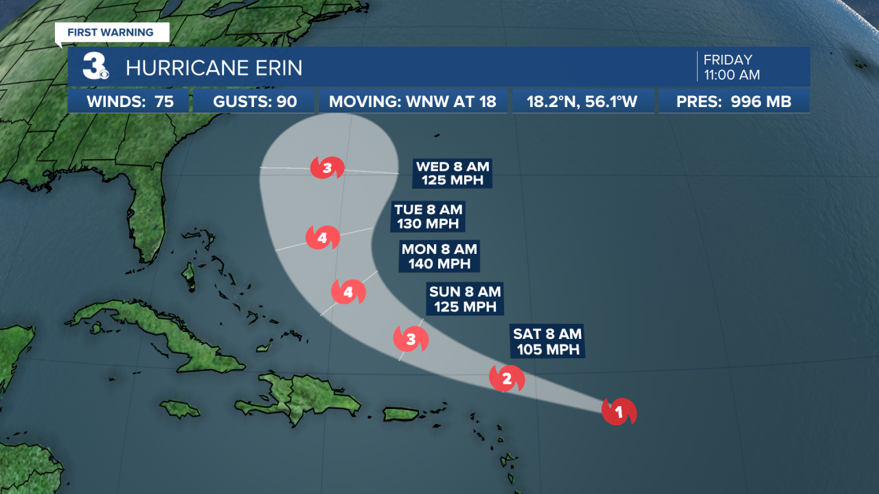
Reports from NOAA and Air Force Reserve Hurricane Hunter aircraft indicate that maximum sustained winds have increased to near 75 mph with higher gusts.
Thursday, Aug. 14, 5 p.m. — Erin continues to become better organized. It was forecast to become a hurricane within the next day. It was then expected to slowly continue strengthening.

It was forecast to become a major (category 3) hurricane by the end of the weekend.
Wednesday, Aug. 13 — Erin continues its journey across the Atlantic. It was centered about 1400 miles east of the northern Leeward Islands and moving west at 20 mph.
Maximum sustained winds were near 45 mph with higher gusts. Amid its gradual strengthening, Erin was forecast to become a hurricane by late Thursday or early Friday.
Tuesday, Aug. 12 — Tropical Storm Erin was tracked to be around 690 miles west of the Cabo Verde Islands. Erin was forecast to become a hurricane in the next couple of days.
Monday, Aug. 11 — A tropical storm, dubbed "Erin," forms just west of the Cabo Verde Islands, which is a few hundred miles west of Senegal.
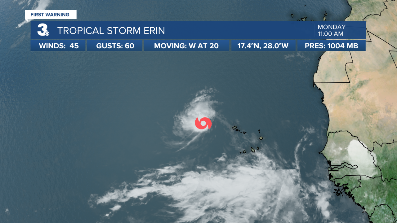
Earlier satellite wind data indicated that maximum sustained winds were near 45 mph with higher gusts. At this time, Erin was moving westward at around 20 mph.
