

Meteorologist Tony Nargi's First Warning Forecast
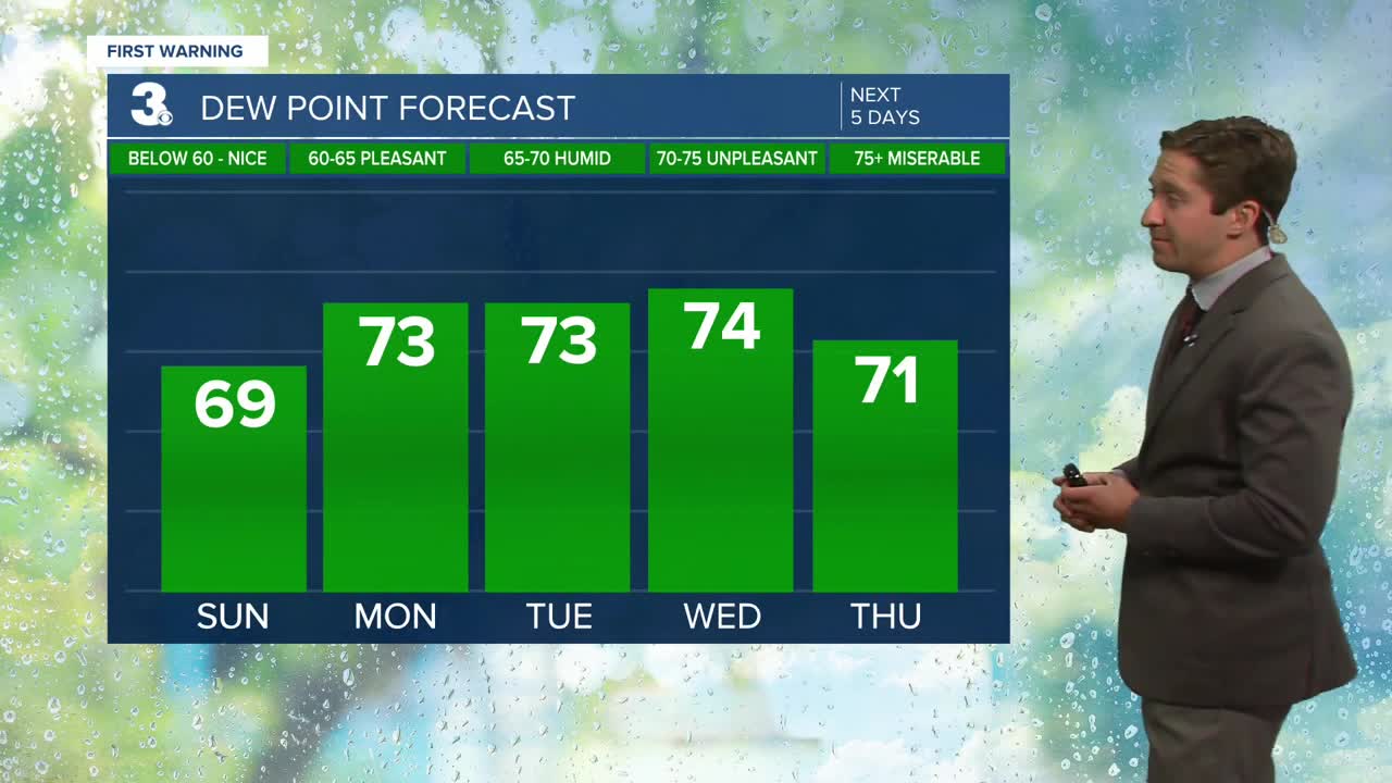
This morning will start off in the 70s with some patchy fog in our eastern counties. This afternoon will be excellent, with seasonably warm temperature in the upper 80s to low 90s by the afternoon along with mainly sunny skies. Dew points will stay around 70, keeping things a bit more comfortable than yesterday in terms of humidity. Winds will be light out of the E at 5-10 mph. Surf will be between 2-3 feet at the oceanfront, with a moderate rip current risk.

Tomorrow we'll see a 20% chance of a passing morning shower followed by mainly sunny skies. We'll have another 20% chance of a spotty storm in the afternoon, but the vast majority of us remain dry. The highs will be a bit cooler than Sunday, with highs in the mid to upper 80s for your Monday. Dew points will climb back into the low to mid 70s, leading to heat indices in the mid 90s. We'll see mostly sunny skies throughout the day with winds out of the NE at 10-15 mph. Tuesday will bring another 20% chance of a passing shower or storm, with mainly dry conditions expected for most. Highs will continue to follow a cooling trend, staying in the low to mid 80s for most. We'll see partly cloudy skies throughout the day with winds out of the ENE at 10-15 mph.

Wednesday into Thursday will bring an increasing chance of showers as Hurricane Erin wraps some moisture into our area as she tracks a few hundred miles offshore. Temps will stay in the low to mid 80s, and it will be breezy on Thursday along the Outer Banks, where gusts could exceed 40 mph at times. Wave heights will be between 10-15 feet just offshore; however, the worst of the impacts (heavy rain & hurricane force winds) stay well offshore.


TRACKING THE TROPICS:
Hurricane Erin has weakened overnight thanks to an Eye-wall Replacement Cycle (EWC), which is common among intense Hurricanes. She has dropped from a category 5 hurricane down to a category 3, with maximum sustained winds of 125 mph. She will likely intensify back to a category 4 later today into tomorrow morning as she continues to move over very favorable conditions.

Her current forecast has not changed much and is still expected to "split the uprights" between the east coast and Bermuda, keeping her away from any major land masses. Cape Hatteras will see the highest chance of being impacted by some outer bands of Erin on Thursday, but most of our area will steer clear of any direct impacts from Erin. Winds could gust over 40 mph on the Outer Banks Thursday, however sustained tropical storm force winds are unlikely, and hurricane force gusts are very unlikely. We'll keep you updated with her forecast, but it still remains very unlikely that we see any direct impacts from Erin.

In other news, a new area of interest has developed just behind Hurricane Erin as a tropical wave makes its way off of West Africa. There is a 20% chance of this wave developing into a tropical depression over the next 7 days.

Weather updates on social media:
