

Meteorologist Tony Nargi's First Warning Forecast
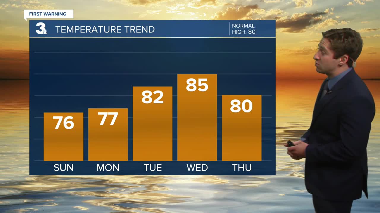
This week will start off pleasantly, with highs in the mid 70s to low 80s. Clouds in the mornings will move off to the north by midday, with partly cloudy to mostly sunny skies expected by the afternoon. It will be a bit breezy, with winds out of the NE at 10-15 mph, with gusts occasionally over 20 mph along the coastline. Dry conditions are expected, with just a 10% chance of a stray sprinkle or shower in the morning. Dew points will be in the mid 60s, so a little humidity should be expected. Surf will be a bit rough, with 3 to 5 foot surf along with a high risk of rip currents.

Tomorrow marks the first day of fall, with the autumnal equinox occurring at 2:19 pm. It will be a great first day of fall, with high temperatures near normal in the upper 70s to low 80s along with mostly sunny to partly cloudy skies. Dew points will stay in the mid 60s. Winds will be a bit lighter, out of the ENE at 5-15 mph. Dry conditions are expected, with just a 10% chance of a spotty afternoon shower. Tuesday will be a bit warmer, with highs jumping into the low to mid 80s. Skies will be partly cloudy, along with dew points staying in the mid 60s. A couple isolated showers/storms will be possible in the afternoon, with a 20% chance of rain. Winds will be light out of the NE at 5-10 mph.


Our weather will start to deteriorate a bit to end the week. Wednesday will be warm with a chance of afternoon storms, with unsettled weather moving in by Thursday and Friday. Chances of rain will stay elevated from Thursday through Saturday.

TRACKING THE TROPICS
Tropical Storm Gabrielle is poised to become a Hurricane over the next day or so. Gabrielle is expected to stay well out to sea, tracking east of Bermuda then heading east towards the Azores this week. No impacts are expected here besides some slightly elevated rip current risks.

Another area in Gabrielle's wake has a 30% chance of forming into a tropical depression this week. We'll keep you updated as this area moves further into the open Central Atlantic.

Weather updates on social media:
