

Meteorologist Tony Nargi's First Warning Forecast
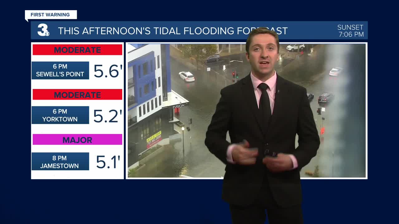
Heavy rain this afternoon and evening will begin to taper off tonight. Coastal flooding combined with the 3-5" of rain in and around Hampton Roads will lead to hazardous driving conditions during the evening commute, please use caution if driving and avoid flooded roadways! Winds will be strong out of the N at 15-25 mph through this evening, dying down by the early morning hours.


Tomorrow will be much calmer, with cloudy skies along with drizzle and a 60% chance of scattered showers. It will still be gloomy, but winds will be much lighter out of the SW at 5-15 mph. Rainfall totals will stay below 0.5", and any areas with leftover standing water should start to dry out. Highs will reach the low to mid 70s, with humid conditions as well. Overnight clouds will begin to clear out, with just a few isolated showers possible with temperatures dropping into the 60s.


Thursday will be a nice one, with some lingering clouds and isolated sprinkles in the morning transitioning to mainly sunny skies in the afternoon. Highs will be closer to normal in the mid 70s to near 80, with light winds out of the NW at 5-10 mph. Friday will be the best day of the week, with mostly sunny skies and highs in the low to mid 80s. Dew points in the mid 60s will make for slightly humid conditions Thursday and Friday.

This weekend will be a nice one, with partly cloudy skies expected on Saturday and Sunday, with just some isolated showers possible on Sunday.

TRACKING THE TROPICS
A tropical system will likely form over the next two days in the Central Atlantic. This area of interest will become Gabrielle if it forms into a tropical storm. Though it's still far too early to tell exactly where this system will go and how strong it will get, the current indication is that it would swing north into the open Atlantic close to Bermuda. Along with this system, there's a low-end chance of formation for another tropical wave right on its tail. We'll keep you updated as things progress this week.

Weather updates on social media:
