

Meteorologist Tony Nargi's First Warning Forecast
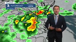
This afternoon tidal flooding is expected thanks to a coastal low that is moving onshore. High tide will be around 5 pm to 7 pm. Showers and breezy conditions will pick up tonight, thunderstorms are possible as well and isolated tornadoes could spin up late tonight into early tomorrow morning. Overnight lows will stay in the 60s, with winds out of the NE at 15-25 mph with gusts to 40 mph.


Tomorrow morning the tornado threat ends by mid-morning, however steady rain and windy conditions will be in place all day. Expect windy, rainy, and soggy conditions all day. Rain will start to taper off Tuesday night, with significant rainfall totals falling through Tuesday of 1-3" expected. Locally heavy rain could produce flash flooding, with up to 4" of rain possible in isolated locations. A wind advisory is in effect until 4 pm Tuesday, with NE winds at 15-25 mph with gusts to 40 mph possible. Coastal flooding will be possible as well, with 1-2 feet of inundation expected during the Tuesday afternoon high tide. A coastal flood warning is in effect from 1 pm to 11 pm Tuesday. Highs will stay in the mid 70s, with humid conditions as dew points jump to near 70.


On Wednesday the wind and rain will calm down a bit as the coastal storm moves onshore and weakens. Scattered showers will be possible throughout the day, with highs in the mid to upper 70s. Winds will be out of the E at 5-15 mph. Some peaks of sunshine will be possible, but mainly cloudy skies are expected. On Thursday the skies will clear throughout the day. Drier weather is also expected, with only a 20% chance of an AM shower. Highs will reach the upper 70s to low 80s.
Nicer weather prevails to end the work week, with mostly sunny conditions expected by Friday that last into Saturday.

TRACKING THE TROPICS
The tropical wave over the Central Atlantic looks poised to become a tropical depression this week, with a 90% chance of formation over the next 7 days and a 50% chance of formation over the next 2 days. This wave will be moving over some favorable waters if it forms, we'll keep you updated on its track over the next week.

Weather updates on social media:
