

Meteorologist Tony Nargi's First Warning Forecast
Muggy and mild conditions continue this evening, with pop up showers and storms dwindling as we get later into the night. Lows will only get down to the low to mid 70s.

Tomorrow will be a hair cooler with more humid conditions in place, with highs reaching the low to mid 80s along with dew points in the mid 70s. Scattered showers will be possible in the afternoon, with about a 30% chance of seeing some rain. We'll see partly cloudy skies with winds out of the E at 10-15 mph. Surf conditions will be rough, with 3-5 foot waves and a high risk of rip currents, a small craft advisory is in place.

Wednesday we'll start to see the effects of Hurricane Erin increase, with mostly cloudy skies and some occasional showers. Winds will begin to pick up along with wave heights, with NE winds at 10-20 mph, gusting up to 30 mph by the evening. Coastal flooding will be possible Wednesday night along the Outer Banks as Erin tracks closer. High temperatures will be in the low to mid 80s.

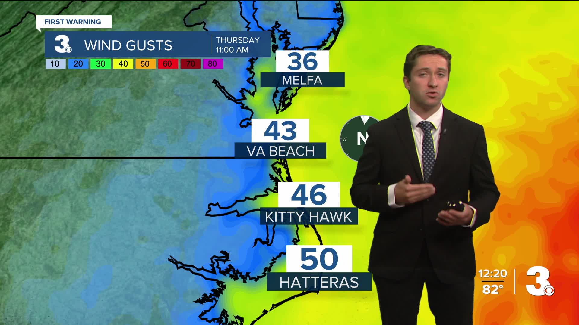
On Thursday we'll see some potential showers and storms from Erin's outer bands, along with strong winds out of the N at 20-30 mph, with occasional gusts over 45 mph. Isolated tornadoes can't be ruled out either, as tropical systems typically pose a threat for brief spin-ups. Tidal flooding is likely on Thursday, and over wash along highway 12 on the Outer Banks is also likely. High tides on Thursday will be at 6:30 am and 7:00 pm. It will be cool, with high temperatures on Thursday in the upper 70s to low 80s.

TRACKING THE TROPICS

Hurricane Erin is currently a category 4 hurricane with maximum sustained winds of 140 mph. She will continue north today and pass a little over 200 miles east of Hatteras on Thursday as a category 2/3 hurricane. She has grown tremendously in size over the last day and is expected to continue growing.

Because of the expectation that Hurricane Erin will continue to grow as she moves north, her impacts will be felt well outside the National Hurricane Center's cone of uncertainty. This will lead to coastal flooding, windy conditions, and showers/storms for coastal areas of VA/NC, especially along the Outer Banks. Tropical storm force gusts will be possible along the immediate shorelines on Thursday, and 10-15' waves will be just offshore as well. Please take note of your flood zone and heed any evacuation orders in place.


Behind Hurricane Erin another zone of interest is moving off of West Africa, and this area now has a 60% chance of developing into a tropical depression over the next 7 days. We'll monitor this area closely after Erin passes to our east on Thursday.

Weather updates on social media:
