


Meteorologist Myles Henderson’s First Warning Forecast
Tracking rain for Thursday, but back to sunshine just in time for the weekend. Very fall-like temperatures in the 60s and 70s.
A small step warmer today with highs in the mid 70s, near or slightly above normal for this time of year. We will see mostly sunny to partly cloudy skies today with slim rain chances.
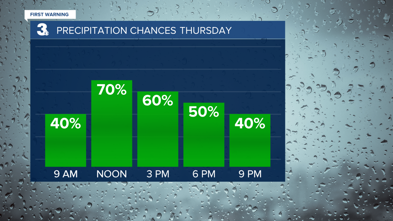
A cold front is set to move through the region on Thursday. Expect mostly cloudy skies with scattered showers and isolated storms throughout the day. Highs will return to the mid 70s on Thursday.
Cooler air will move in behind the cold front. Highs will drop to the upper 60s on Friday. Clouds will clear out early in the morning, so most of the day will be sunny.

The upcoming weekend looks nice! Expect mostly sunny skies both days with highs in the low 70s on Saturday and mid 70s on Sunday. Scattered showers will return to start next week.
Today: Partly Cloudy. Highs in the mid 70s. Winds: SE 5-10
Tonight: Partly Cloudy. Lows in the low 60s. Winds: SE 5-10
Tomorrow: Showers & Storms. Highs in the mid 70s. Winds: S 5-15
Weather & Health
Pollen: Low (Ragweed, Grasses)
UV Index: 4 (Moderate)
Air Quality: Good (Code Green)
Mosquitoes: Moderate
Tropical Update
Tropical Storm Karl forms over the southwestern Gulf of Mexico. On the forecast track, Karl will be approaching the coast of Mexico on Thursday. Maximum sustained winds are near 40 mph with higher gusts. Gradual strengthening is expected for the next day or so, followed by gradual weakening on Thursday.

Weather updates on social media:
Facebook: MylesHendersonWTKR
Twitter: @MHendersonWTKR
Instagram: @MylesHendersonWTKR
