


Meteorologist Myles Henderson’s First Warning Forecast
One more gloomy day, then it’s back to sunshine for the end of the week. Temperatures are on the rise too, near 80 by Friday.
Another messy morning with cloudy skies, scattered showers, and drizzle. It will still be breezy today but not as windy as yesterday. Expect NW winds at 10 to 15 with gusts to 20 mph. Rain chances will slowly drop, and clouds will start to break up later today and tonight.

We will see major improvements for Thursday and Friday. Expect partly cloudy to mostly sunny skies on Thursday with highs in the mid 70s and light winds. Highs will warm to the upper 70s on Friday with lots of sunshine.

A dry cold front will cool us down for the weekend. Highs will drop to the mid 60s both days. We will see some extra clouds in the mix for Saturday as north winds kick up. Winds will relax and we’ll return to sunshine on Sunday.
Today: Mostly Cloudy, Showers, Breezy. Highs in the mid 60s. Winds: NW 10-15G20
Tonight: Partly Cloudy. Lows in the mid 50s. Winds: NW 5-15
Tomorrow: Partly Cloudy. Highs in the mid 70s. Winds: NW/SW 5-10
Weather & Health
Pollen: Low (Ragweed, Sagebrush)
UV Index: 2 (Low)
Air Quality: Good (Code Green)
Mosquitoes: Moderate
Tropical Update
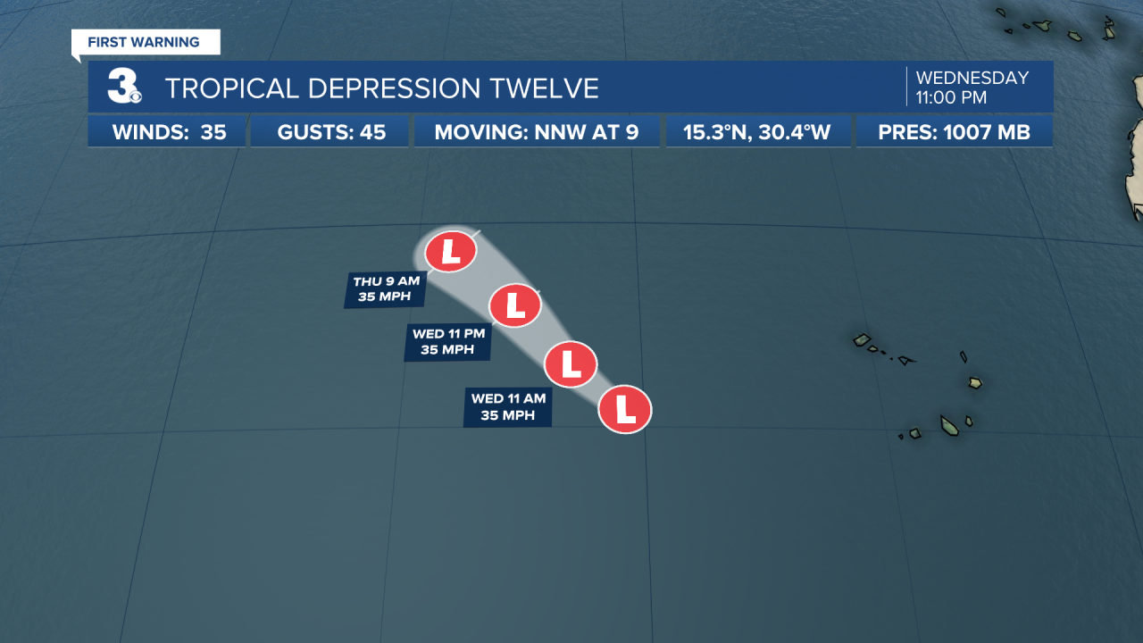
Tropical Depression Twelve is located in the open Atlantic west of the Cabo Verde Island. A general motion towards the NW or NNW is expected through Thursday. Maximum sustained winds are near 35 mph with higher gusts. Little change in strength is forecast and the system is expected to dissipate in a couple of days.
A broad area of low pressure located just east of the Windward Islands continues to produce a large area of showers and thunderstorms. Satellite-derived wind data and radar images from Barbados indicate that this system does not yet have a well-defined circulation center. However, upper-level winds are forecast to become more conducive for development, and a tropical depression is likely to form over the next several days if the system remains over open waters while moving generally west at about 15 mph through the Windward Islands and into the Caribbean Sea.
* Formation chance through 48 hours: Medium (60%)
* Formation chance through 5 days: High (80%)

Weather updates on social media:
Facebook: MylesHendersonWTKR
Twitter: @MHendersonWTKR
Instagram: @MylesHendersonWTKR
