


Meteorologist Myles Henderson’s First Warning Forecast
Highs near 80 with more humidity to end the week. Several chances for showers and storms.
Don’t forget your umbrella! We will see a mix of clouds today with scattered showers building throughout the day. Highs will only climb to near 80 with more humidity. Look for the wind to start to pick up this afternoon.

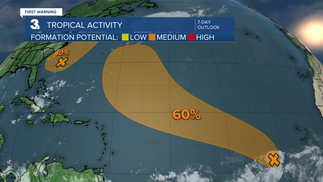
Temperatures will linger near 80 for the rest of the week with a NE wind at 10 to 20 and gusts to 30 mph. Expect a mix of clouds with scattered showers and isolated storms as an area of low-pressure develops off the Carolina coastline. There is the potential for some tropical development with this coastal low.

Highs will reach the low to mid 80s this weekend. Expect partly cloudy skies with a lower chance for showers and storms. Temperatures will start to climb again early next week.

Today: Scattered Showers. Highs in the low 80s. Winds: NE 5-15
Tonight: Scattered Showers. Lows in the low 70s. Winds: NE 5-15
Tomorrow: Scattered Showers. Highs in the upper 70s. Winds: NE 10-20
Weather & Health
Pollen: Medium (Grasses)
UV Index: 6 (Medium-High)
Air Quality: Good (Code Green)
Mosquitoes: Extreme
Tropical Update
Tropical Storm Dexter continues moving generally NE toward the northern Atlantic. Maximum sustained winds have increased to near 45 mph with higher gusts. Strengthening is forecast during the next 48 hours while the system becomes an extratropical cyclone.

Watching a tropical wave over the eastern tropical Atlantic. Environmental conditions are forecast to be conducive for gradual development during the next few days, and a tropical depression could form late this week or over the weekend as the system moves generally WNW across the central tropical or subtropical Atlantic.
* Formation chance through 48 hours: Low (20%)
* Formation chance through 7 days: Medium (60%)
An area of low pressure is expected to develop off the coast of the southeastern U.S. over the next day or so. Environmental conditions appear generally favorable for additional development. A tropical depression could develop late this week or this weekend as the low drifts west before gradually turning north to NE by the weekend.
* Formation chance through 48 hours: Low (10%)
* Formation chance through 7 days: Medium (40%)
Weather updates on social media:
Facebook: MylesHendersonWTKR
Instagram: @MylesHendersonWTKR
