


Meteorologist Myles Henderson’s First Warning Forecast
A Tornado Watch has been issued for South Eastern Virginia and North Eastern North Carolina until 10 p.m. Friday.
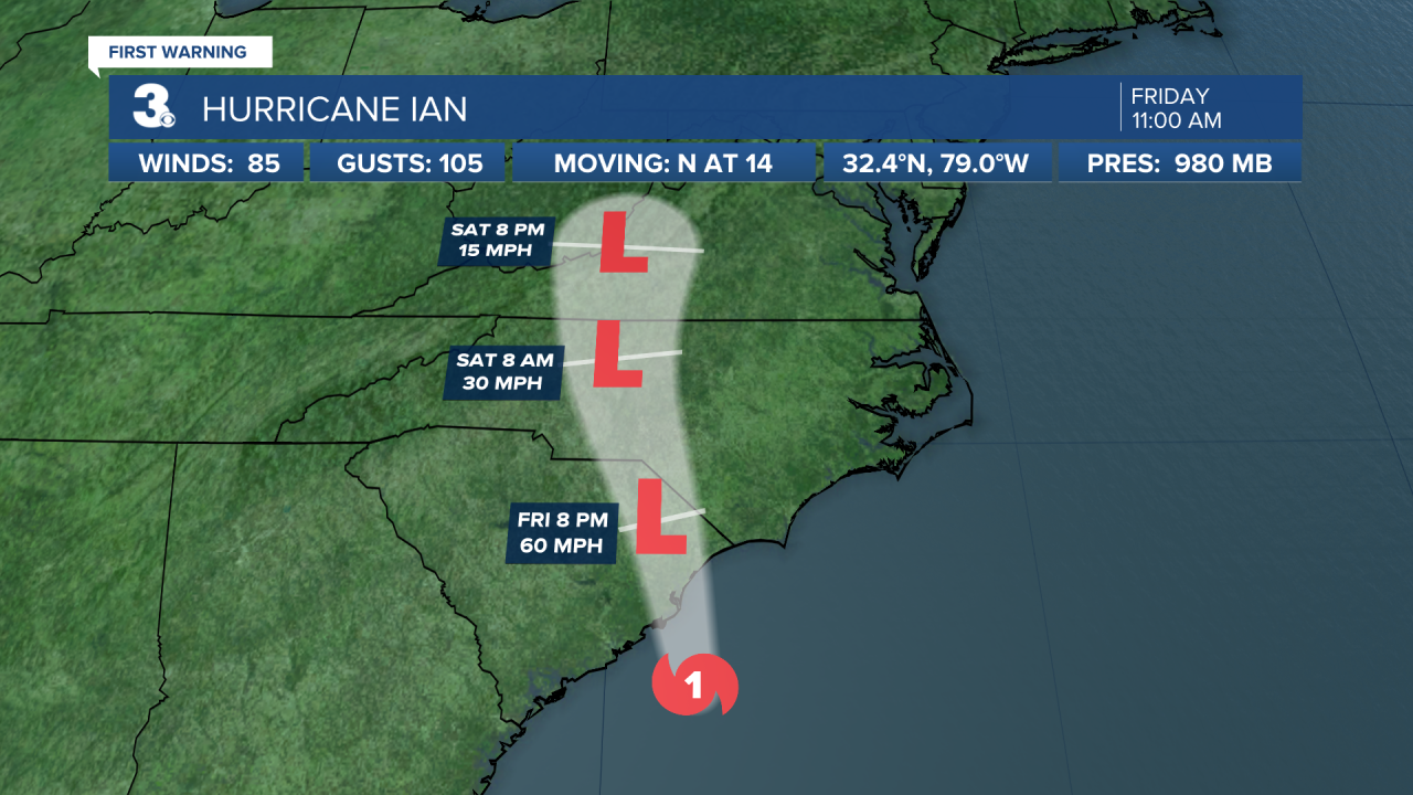
Ian's remnants will continue to bring us rain, storms, wind, and flooding.
Expect cloudy skies with widespread rain throughout the day. Strong to severe thunderstorms will mix in with a risk for isolated tornadoes. It will be extremely windy today with NE/E winds at 20 to 30 mph and gusts of 40 to 50 mph. Watch out for “moderate” level flooding near times of high tide early this afternoon. We will also see 2 to 4 feet of storm surge on the Outer Banks with the potential for overwash.

The leftovers of Ian will linger over the Mid-Atlantic this weekend to early next week. Rain chances will be lower on Saturday with a mix of clouds. Winds will back down and shift to the SE Saturday as we warm to near 80. Winds will turn back to the NE on Sunday with more clouds and rain. Highs will return to the 70s on Sunday.
Showers and wind will continue for early next week. Expect mostly cloudy skies with scattered showers Monday and Tuesday. N/NE winds will stay strong early in the week. Winds will relax and we will return to sunshine by midweek.

Today: Rain, Storms, Windy. Highs near 70. Winds: NE/E 20-30G40+
Tonight: Rain, Storms, Windy. Lows in the mid 60s. Winds: E 20-30G40
Tomorrow: Showers, Windy. Highs near 80. Winds: SE 10-20
Weather & Health
Pollen: Low (Ragweed, Sagebrush)
UV Index: 1 (Low)
Air Quality: Good (Code Green)
Mosquitoes: High
Tropical Update
Hurricane Ian is centered about 60 miles ESE of Charleston, SC and moving north at 14 mph. On the forecast track, the center of Ian will reach the coast of South Carolina today, and then move farther inland across eastern South Carolina and central North Carolina tonight and Saturday.
Maximum sustained winds remain near 85 mph with higher gusts. Ian should maintain about the same strength before landfall, then weaken and rapidly transition into a post-tropical cyclone overnight. Ian should dissipate over western North Carolina or Virginia late Saturday.
Hurricane-force winds extend outward up to 70 miles from the center and tropical-storm-force winds extend outward up to 275 miles.
A tropical wave is producing disorganized showers and thunderstorms over the far eastern tropical Atlantic. Environmental conditions are forecast to be conducive for gradual development of this system, and a tropical depression could form early next week as the system moves westward to west-northwestward over the eastern tropical Atlantic.
* Formation chance through 48 hours: Low (10%)
* Formation chance through 5 days: Medium (60%)
Weather updates on social media:
Facebook: MylesHendersonWTKR
Twitter: @MHendersonWTKR
Instagram: @MylesHendersonWTKR
