


Meteorologist Tony Nargi's First Warning Forecast
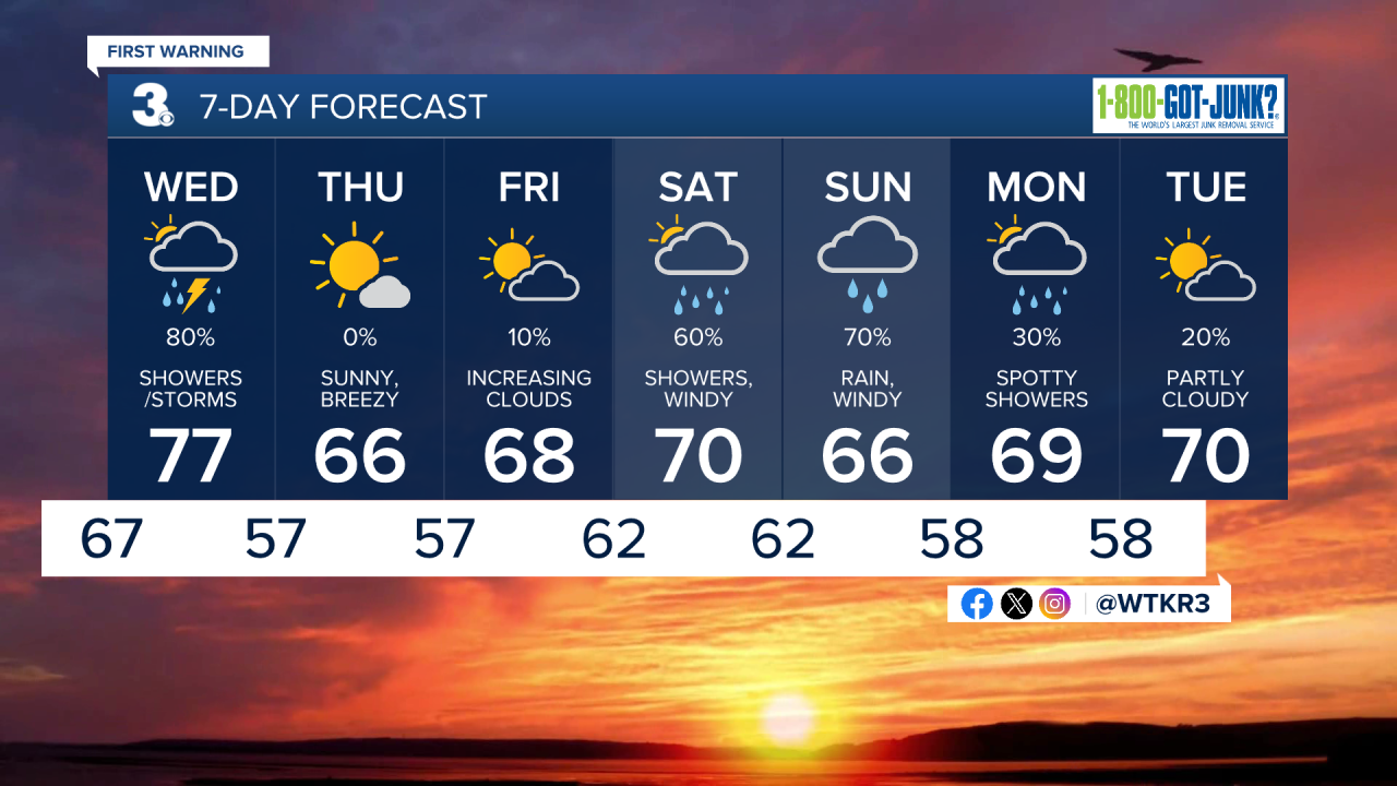
This evening clouds will start to fill in with pleasant temperatures in the 70s along with a breeze out of the S at 10-15 mph. Overnight temperatures fall into the 60s with skies becoming overcast. Some isolated showers are possible towards the end of the night as a cold front approaches.

Tomorrow will start off with mostly cloudy skies along with an increasing chance of showers. By Wednesday afternoon widespread showers and thunderstorms are likely, with about 0.25" to 0.50" of rain expected for most, though some areas could reach around 1 inch of rain. High temperatures will reach the mid to upper 70s. Winds will be out of the SW at 10-15 mph, turning out of the N at 10-20 mph to end the day after the passage of the cold front. Overnight temperatures drop into the 50s as skies clear out.

Thursday will be mostly sunny along with cool conditions, with highs struggling to make it out of the 60s. It will be windy, with winds out of the NE at 10-20 mph. Some minor tidal flooding will be possible during the Thursday high midday high tide cycle, around 11 am. Dew points will drop into the 50s, with dry conditions expected. Friday will be pleasant and cool, with highs in the upper 60s and a mix of sun and clouds expected. Clouds will begin to increase Friday afternoon ahead of an approaching coastal storm.

Saturday will be windy with showers becoming more frequent during the afternoon as a coastal low brings wind, rain, and tidal flooding to the area. This will be a significant storm, with wind gusts over 40 mph possible on Sunday along with over 2" of rain possible from Saturday through Sunday. We'll keep you updated on the timing and impact of the storm as the weekend approaches.

TRACKING THE TROPICS
Tropical Storm Jerry formed in the Central Atlantic today and is expected to become a category 1 hurricane later in the week. Jerry will likely stay out to sea and is not expected to impact our area at this time. We'll continue to monitor Tropical Storm Jerry here and will let you know if anything changes.

Weather updates on social media:
