


Meteorologist Myles Henderson’s First Warning Forecast
A nice end to the week… A cooler start to the day with temperatures in the 50s, 10 to 15 degrees cooler than yesterday morning. Highs will reach the mid to upper 70s this afternoon, near normal for this time of year. Expect a nice mix of mostly sunny to partly cloudy skies today with lighter winds and low rain chances.
Temperatures will drop to the low and mid 70s on Friday with mostly sunny skies. We will warm back to the upper 70s on Saturday and low to mid 80s on Sunday. It will be a nice weekend with more sunshine on Saturday and building clouds on Sunday. Rain chances will remain slim.
Our next decent chance for rain is set to move in with a cold front early next week. The biggest rain chances will likely be Tuesday to Wednesday. Highs will fall from the 80s to the 70s behind the cold front.
Today: Sun & Clouds. Highs in the upper 70s. Winds: N 5-10
Tonight: A Few Clouds. Lows near 60. Winds: N/E 5-10
Tomorrow: Mostly Sunny. Highs in the mid 70s. Winds: NE 5-10
Weather & Health
Pollen: Low-Medium (Ragweed, Grass)
UV Index: 6 (High)
Air Quality: Good (Code Green)
Mosquitoes: Very High
Tropical Update
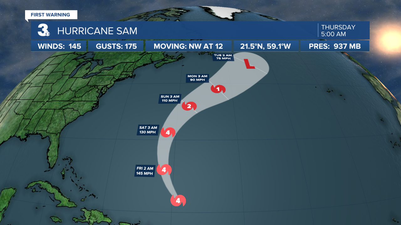
Hurricane Sam is centered about 345 NE of the northern Leeward Islands and moving NW at 12 mph. On the forecast track, the core of Sam will continue to pass well to the northeast of the northern Leeward Islands this morning and pass to the east of Bermuda early Saturday. Data from an Air Force Reserve Hurricane Hunter aircraft indicate that the maximum sustained winds are near 145 mph with higher gusts. Sam is a category 4 hurricane on the Saffir-Simpson Hurricane Wind Scale. Some fluctuations in intensity are expected during the next couple of days, but Sam is forecast to remain a major hurricane through Saturday, with more significant weakening anticipated later in the weekend.
Tropical Storm Victor is centered about 550 miles SSW of the Cabo Verde Islands and moving WNW at 13 mph. A WNW to NW motion over the eastern tropical Atlantic is expected through the weekend. Maximum sustained winds have increased to near 45 mph with higher gusts. Additional strengthening is forecast, and Victor could become a hurricane on Friday. A weakening trend is expected to begin over the weekend.

Shower activity associated with a trough of low pressure located over the tropical Atlantic about midway between the Cabo Verde Islands and the Lesser Antilles has become limited. Environmental conditions are forecast to become less conducive over the next few days, and significant development of this system is no longer anticipated. The disturbance is forecast to move west at 10 to 15 mph.
* Formation chance through 48 hours: Low (10%)
* Formation chance through 5 days: Low (10%)
Weather updates on social media:
Facebook: MylesHendersonWTKR
Twitter: @MHendersonWTKR
Instagram: @MylesHendersonWTKR
