


Meteorologist April Loveland's First Warning Forecast
A weak cold front will move through the area today and tonight. Keeping a slight chance for a spotty shower. Otherwise expect mostly to partly sunny skies. Highs will warm to the low and mid 80s. It will still be a bit muggy.
High pressure will build in to start the work week. Expect dry weather with highs in the low 80s under partly cloudy skies. Still looking dry on Tuesday with highs in the low 80s, but expect more cloud cover. Dewpoints will be in the mid and upper 60s Monday and Tuesday.
A strong cold front will move in on Wednesday with a chance for afternoon showers and storms. Highs will once again be in the low 80s. It will feel warmer due to an increase in the humidity. Even though Fall arrives at 3:21 PM, it won't feel very fall-like just yet. Showers will continue overnight and into the day Thursday. Thursday will be a bit breezy with highs only in the mid 70s and falling humidity.
Very fall-like to end the work week as drier air works into the area. Highs will reach the low 70s with dewpoints in the
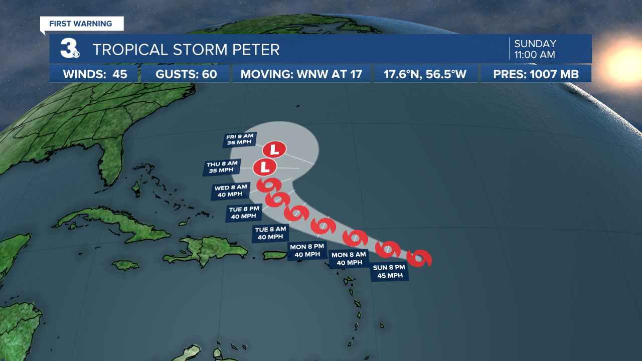
Tropical Update:
Peter is moving toward the west-northwest near 17 mph, and this general motion along with a gradual decrease in forward speed is expected through Tuesday. A turn to the northwest is expected to occur by Wednesday. On the forecast track, the center of Peter is expected to pass well north of the Leeward Islands on Monday and Tuesday. Maximum sustained winds remain near 45 mph with higher gusts. Little change in strength is forecast through today. Some slight weakening is expected tonight into Monday. Tropical-storm-force winds extend outward up to 115 miles, primarily northeast of the center.
The depression is moving toward the north-northwest near 14 mph, and this motion is expected to continue today. A motion toward the northwest is forecast to begin by tonight and continue through Tuesday. Maximum sustained winds are near 35 mph with higher gusts. Some strengthening is expected for the next couple of days, and the depression is likely to become a tropical storm tonight or Monday. By Tuesday, environmental conditions are expected to become less conducive for development, and the system is forecast to begin a slow weakening trend.

Meteorologist April Loveland
For weather updates on Facebook: HERE
Follow me on Twitter: HERE
Follow me on Instagram HERE
Check out the Interactive Radar on WTKR.com: Interactive Radar
