Meteorologist April Loveland's First Warning Forecast
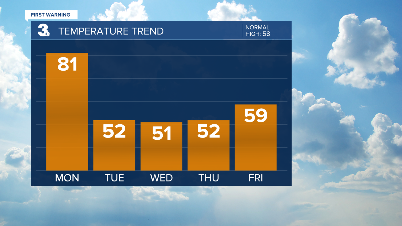
Today will be the warmest day of the week. It will once again be windy with winds out of the southwest at 15-25 mph, and gusts 30-40 mph possible.
![Temperature Bar Graph - 5 Day.png](https://ewscripps.brightspotcdn.com/dims4/default/c8bfc84/2147483647/strip/true/crop/1920x1080+0+0/resize/1280x720!/quality/90/?url=http%3A%2F%2Fewscripps-brightspot.s3.amazonaws.com%2Fcc%2F9e%2Fe91387a64d0bb52ab9c88aedb91f%2Ftemperature-bar-graph-5-day.png)
A cold front will approach late and cross the area on Tuesday. Showers will move in late tonight into early Tuesday.
![Rain Chances Bar Graph 2.png](https://ewscripps.brightspotcdn.com/dims4/default/8b0b0e2/2147483647/strip/true/crop/1920x1080+0+0/resize/1280x720!/quality/90/?url=http%3A%2F%2Fewscripps-brightspot.s3.amazonaws.com%2Fae%2F8e%2Fa30e3025472d80e41b2d4c795dfd%2Frain-chances-bar-graph-2.png)
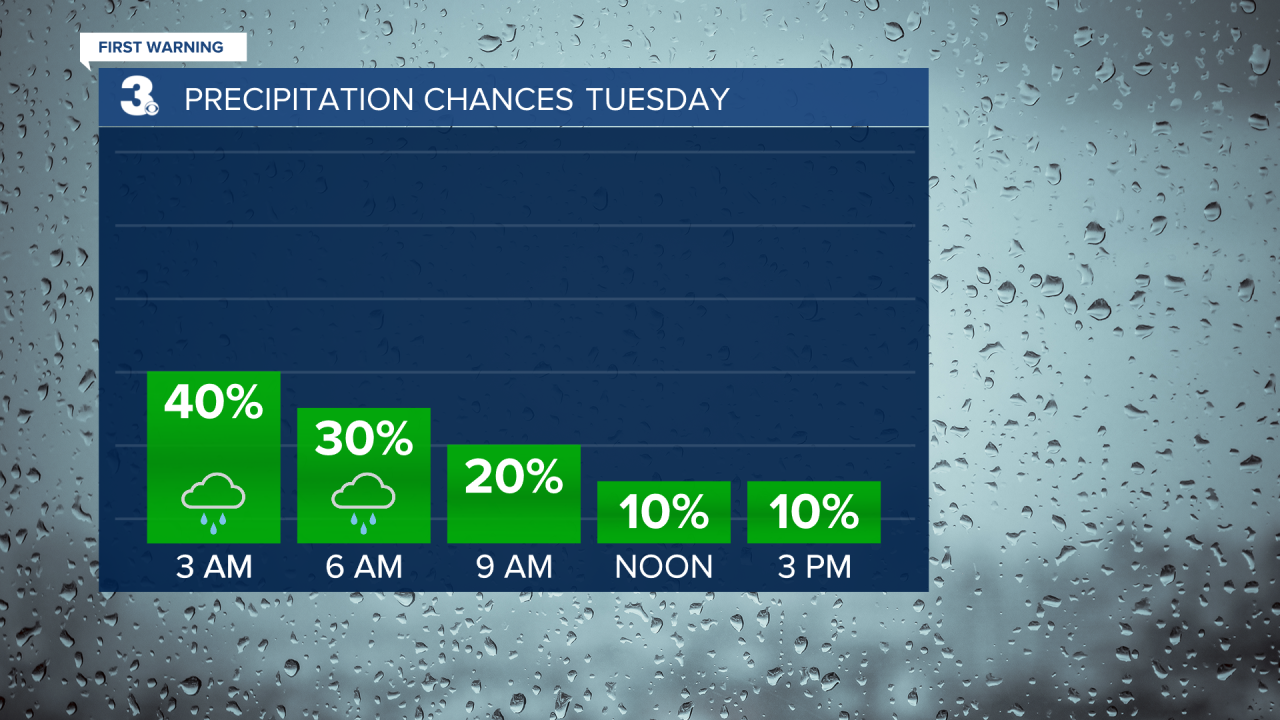
Expect light showers to move out Tuesday by 6 AM. Skies will turn partly cloudy and the winds will relax. It will be much cooler, with highs only reaching the low 50s, which is below normal for this time of year.
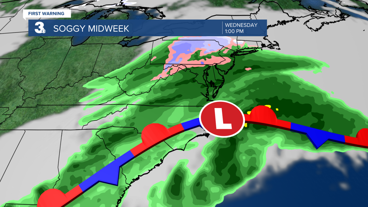
An area of low pressure will move along a stalled front on Wednesday bringing more rain to the area. It will be a soggy day with highs in the low 50s.
![Surface Map Forecast.png](https://ewscripps.brightspotcdn.com/dims4/default/c64284d/2147483647/strip/true/crop/1920x1080+0+0/resize/1280x720!/quality/90/?url=http%3A%2F%2Fewscripps-brightspot.s3.amazonaws.com%2F6c%2Fbd%2F444ac32f40b7a11262445f714563%2Fsurface-map-forecast.png)
A few showers will be possible on both Thursday, mainly for North Carolina.
Another cold front will move in to end the work week. Expect scattered showers Friday night and Saturday morning. Temperatures will warm to the 60s on Saturday and then fall into the 40s behind the cold front on Sunday.
Don't forget to turn your clocks forward one hour before you head to bed on Saturday!
![Daylight Saving.png](https://ewscripps.brightspotcdn.com/dims4/default/eba523f/2147483647/strip/true/crop/1920x1080+0+0/resize/1280x720!/quality/90/?url=http%3A%2F%2Fewscripps-brightspot.s3.amazonaws.com%2Fa5%2Fba%2Fc196a9c14c82adcf96e9e003e5dc%2Fdaylight-saving.png)
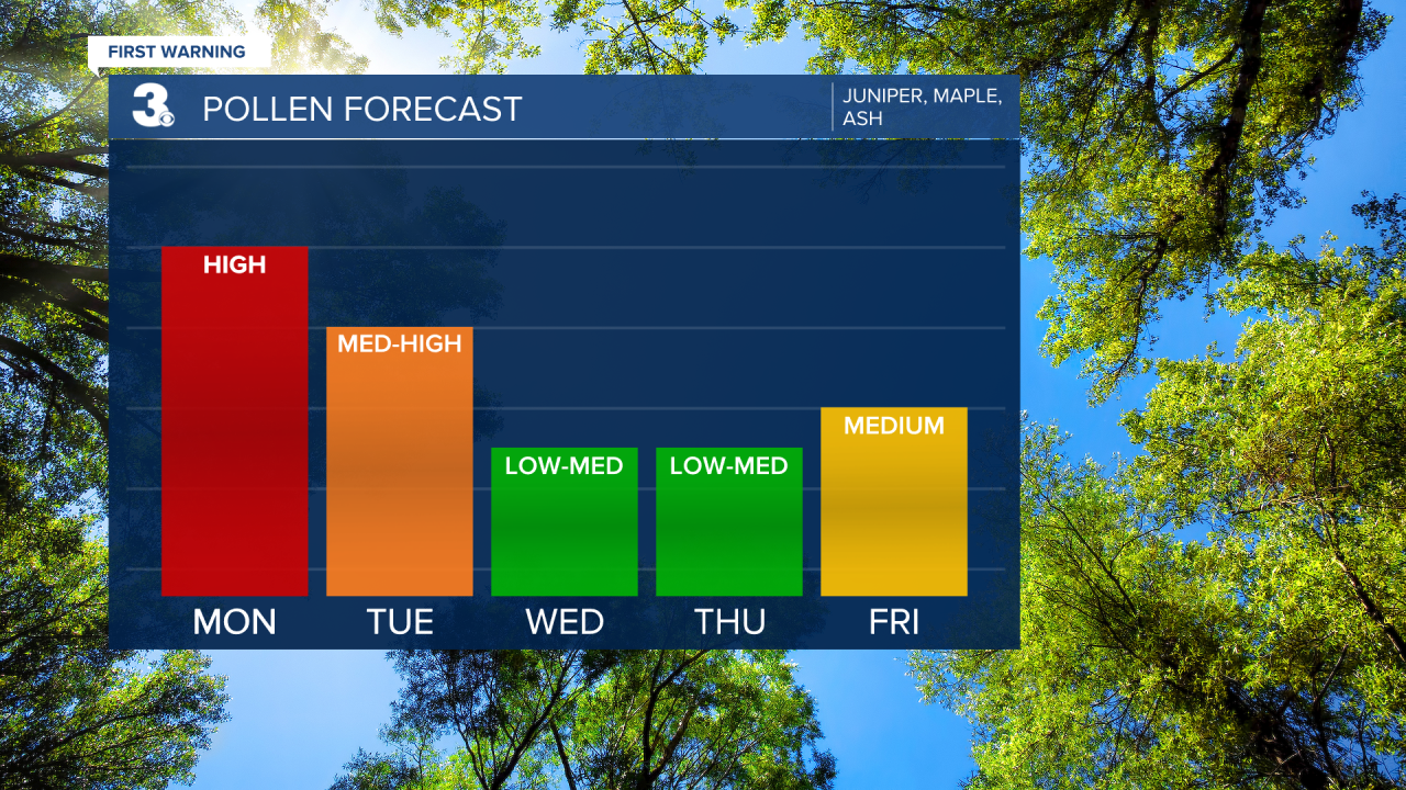
Check out your Pollen Forecast!
![Pollen Bar Graph.png](https://ewscripps.brightspotcdn.com/dims4/default/67f8a69/2147483647/strip/true/crop/1920x1080+0+0/resize/1280x720!/quality/90/?url=http%3A%2F%2Fewscripps-brightspot.s3.amazonaws.com%2F96%2F9c%2F640e12924b088f2874bf75d9c1a3%2Fpollen-bar-graph.png)
Meteorologist April Loveland
For weather updates on Facebook: HERE
Follow me on Twitter: HERE
Follow me on Instagram HERE
Check out the Interactive Radar on WTKR.com: Interactive Radar