


Meteorologist Kristy Steward's First Warning Forecast
Happy Thursday night! We had a quiet, but gloomy day today. Tomorrow is going to be much different with the threat for severe storms – again.
As we stay in this unsettled pattern, a stationary boundary to our south will lift north as a warm front Friday afternoon, then stall out over us where a low pressure system will form along the front. This means some soggy and potentially dangerous weather for us the next few days.
Tonight will remain dry and warm. Lows in the upper 50s. Dense patchy fog is possible late tonight into early Friday morning. Rounds of scattered showers and storms are likely Friday. With the warm front, temperatures climb into the upper 70s and we’ll have a good increase in moisture in the atmosphere. That will set us up for the threat of severe weather.

We are under a Level 2 out of 5 risk for severe storms Friday evening into Friday night. Main threats include damaging winds, large hail, isolated tornadoes, and heavy downpours. Stay weather alert later Friday.

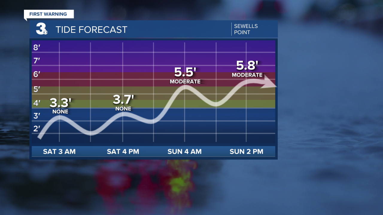
Saturday this low pressure system will move offshore, however it will linger just offshore for the first half of next week. That will bring us coastal flooding, high surf, and the threat of beach erosion.
Already looking like moderate tidal flooding during high tide 2 AM and 2 PM Sunday. Tidal flooding will likely continue through Tuesday. Waves on the Chesapeake Bay will be 2-3’ Saturday, 4-7’ Sunday, and 3-6’ Monday. Waves in the Atlantic Ocean will be 3-5’ Saturday, 10-13’ Sunday, and 9-13’ Monday.
Aside from coastal flooding and high surf, temperatures will be getting cooler and we stay in a soggier pattern. Highs Saturday will still be seasonable in the mid 70s, but they drop throughout the day Sunday. Highs in the low 60s Sunday will be reached earlier in the day. They’ll drop to the low 50s overnight. Highs stay in the low 60s Monday, then gradually warm to the low 70s by next Thursday.
Expect scattered storms mainly across NC Saturday. Then off/on scattered showers Sunday - Tuesday. Unfortunately not looking like the best Mother’s Day this year. Maybe plan some indoor celebrations!
Connect with Meteorologist Kristy Steward:
