


Meteorologist Kristy Steward's First Warning Forecast
Happy Saturday night! It was a hotter day today, then some strong storms helped cool us off this evening. However, these storms won’t stop our warming trend. Temperatures continue to climb the next several days, feeling like the depths of summer. With that summertime heat will come summertime pop-up storms.
The strong/severe storms we have this evening will clear out tonight. Our severe threat should end by 10 PM with rain ending closer to Midnight. After the rain ends, clouds will clear out. Overnight lows in the low 70s.
Lots of sunshine to start the day Sunday. Temperatures climb a couple more degrees into the low 90s. South-southwest winds will be a bit breezier, 5-15 MPH with gusts up to 20 MPH. In the afternoon, clouds start to develop along with some isolated storms. Not everyone will see rain, but a handful of us will likely hear rumbles of thunder and get wet.
Monday will be about a degree warmer than Sunday, still in the low 90s. Some scattered showers across Dare county Monday morning and isolated storms possible for everyone Monday afternoon and evening. Again, not everyone will see rain, but some likely will.
Tuesday high temperatures will stay in the low 90s with plenty of sunshine. Spotty showers/storms possible in the afternoon and evening.
Wednesday will be a dry, sunny, and extremely hot day. Highs in the mid 90s, feeling like we’re over 100°, close to 105°. If you have to do anything outdoors, get it done early in the day Wednesday.
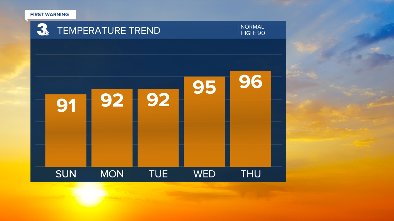
Dangerous heat continues Thursday. That will be our hottest day of the week. Right now, I have a forecast high of 96° and feels-like temperatures 105-110°. There will at least be a breezy Thursday, but it will be best to beat the heat by staying indoors. Evening/overnight scattered storms will help to cool us down Friday and Saturday.
Both days will still be hot with highs around 93°. Some isolated shower/storm activity is possible Friday and just a few stray showers possible Saturday.
Connect with Meteorologist Kristy Steward:
FACEBOOK
TWITTER
INSTAGRAM
