


Meteorologist April Loveland's First Warning Forecast
We'll have mostly sunny skies today with a few clouds building in during the afternoon as a dry cold front crosses the area. Expect a comfortable and gorgeous day overall with highs in the mid and upper 70s.
More sunshine will break out on Sunday with highs in the mid and upper 70s as high pressure builds in. Cooler Sunday night due to mostly clear skies. Expect most areas to fall into the 50s, but could see some upper 40s inland.
Temperatures will start to climb to kick off the work week as winds turn to the southwest. Highs will warm to the low 80s with plenty of sunshine.
A cold front will move in on Tuesday. Humidity and temperatures will climb with highs in the mid 80s. Keeping storm chances slight right now. Winds will pick up out of the southwest at 10-15 mph.
Turning breezy on Wednesday with temperatures about 10 degrees cooler in the mid 70s. Winds will be out of the north at 10-15 mph with higher gusts.
Another system will move in for Thursday and Friday. Right now, looks like most of the wet weather will stay to our north, but we'll keep a slight chance for a spotty shower. It will be on the windy side both days with winds out of the north at 15-20, with gusts up to 30 mph possible. Highs will warm to the low and mid 70s.
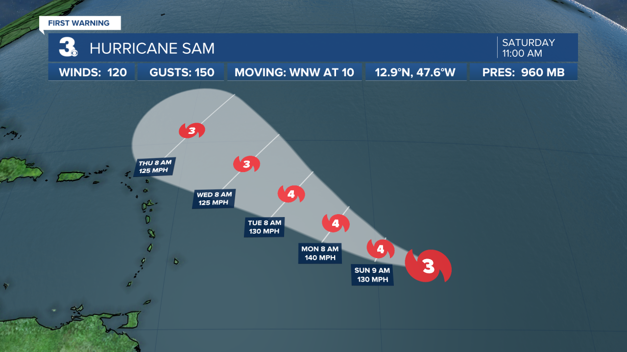
Tropical Update:
Subtropical Depression Teresa is located about 140 miles north of Bermuda. Teresa is nearly stationary. A motion toward the northeast is expected to begin this afternoon and continue through Sunday morning. Maximum sustained winds are near 35 mph with higher gusts. Teresa is expected to become a remnant low by this evening and dissipate on Sunday.

Sam now a major hurricane and is located about 1095 miles ESE of the Northern Leeward Islands. Sam is moving toward the west-northwest near 10 mph. A slower motion to the west-northwest is expected over the weekend, followed by a turn to the northwest on Monday. Maximum sustained winds have increased to near 120 mph with higher gusts. Sam is a category 3 hurricane. Additional strengthening is expected over the next day or so, and Sam is forecast to become a category 4 hurricane by Sunday. Some fluctuations in the hurricane's intensity are possible early next week. Sam is a small hurricane. Hurricane-force winds extend outward up to 25 miles from the center and tropical-storm-force winds extend outward up to 105 miles.
Meteorologist April Loveland
For weather updates on Facebook: HERE
Follow me on Twitter: HERE
Follow me on Instagram HERE
Check out the Interactive Radar on WTKR.com: Interactive Radar
