


Meteorologist April Loveland's First Warning Forecast
Post-tropical Fred continues to track to the northeast today. Some of the outer rain bands will reach us here. Heavy downpours will be possible along with the threat of strong to severe storms. The best chance for severe storms will be on the peninsulas and the Eastern Shore. It will be hot and humid with highs in the upper 80s, but will feel closer to the upper 90s.
A hot one on tap Thursday. It will be the hottest day of the week with highs in the low 90s, but will feel closer to the triple digits. A few storms will be possible by the afternoon.
The unsettled weather pattern will carry into the end of the week and into the weekend. Highs will be in the upper 80s with afternoon storms possible everyday. Not expecting a washout.
Mostly dry and warm heading into the start of the work week with highs in the upper 80s.
Tropical Update
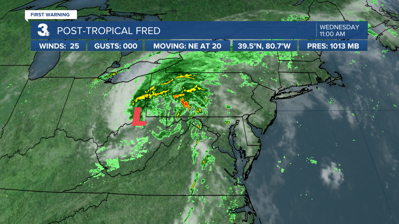
Post-tropical cyclone Fred is located about 180 miles west-southwest of State College, Pennsylvania. The system is moving toward the northeast near 20 mph and this motion is expected to continue today with a gradual turn east tonight. Maximum sustained winds are near 25 mph with higher gusts. Little change in strength is forecast during the next 48 hours.
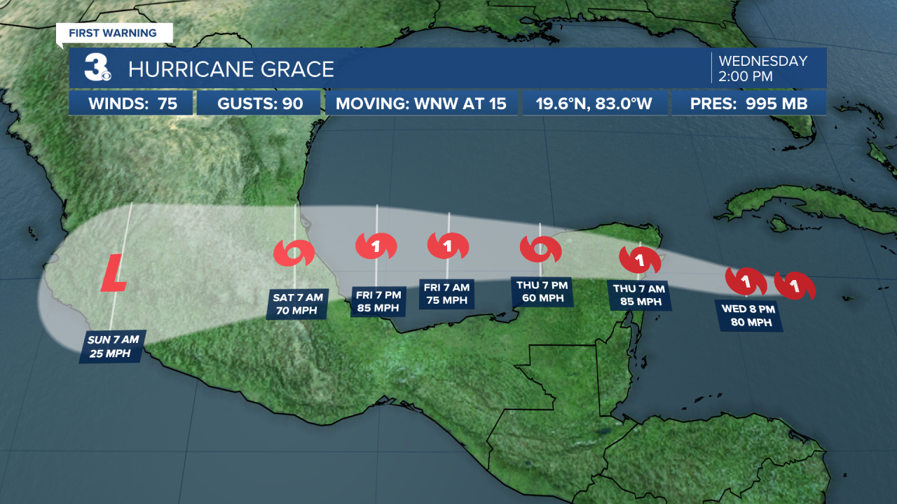
Grace is moving toward the west-northwest near 15 mph. A general west-northwestward to westward motion is expected for the next several days. On the forecast track, Grace is expected to make landfall in the eastern Yucatan Peninsula Thursday morning, move over the Yucatan Peninsula on Thursday, and move over the southwest Gulf of Mexico Thursday night or early Friday. Maximum sustained winds are near 75 mph with higher gusts. Some strengthening is forecast before the center of Grace reaches the Yucatan Peninsula. Weakening will occur while the center moves over the Yucatan Peninsula on Thursday, with restrengthening expected when Grace moves over the southwest Gulf of Mexico on Friday. Hurricane-force winds extend outward up to 25 miles from the center and tropical-storm-force winds extend outward up to 140 miles.
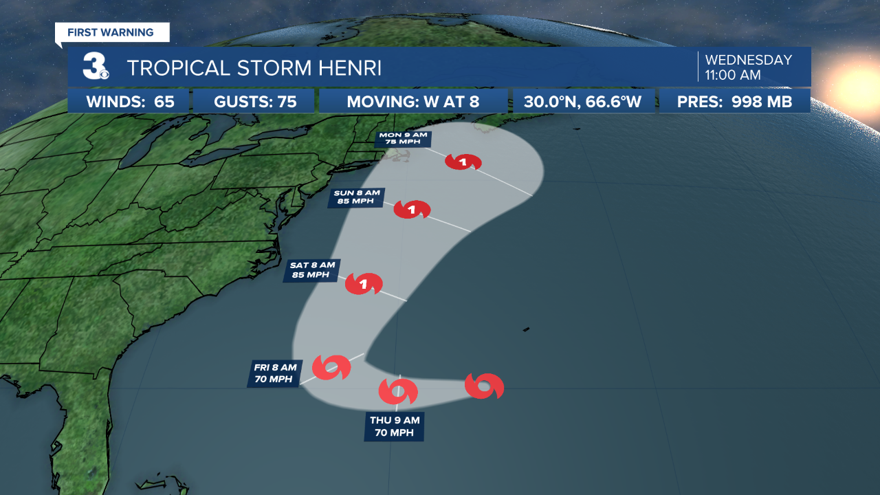
Henri is moving toward the west near 8 mph and this motion is expected to continue for another day or so. A turn to the north is expected on Friday with that motion continuing into the weekend. Maximum sustained winds are near 65 mph with higher gusts. Little change in strength is forecast during the next couple of days, but Henri is expected to become a hurricane by the weekend. Tropical-storm-force winds extend outward up to 80 miles from the center.
Swells are expected to increase across much of the east coast of the U.S. and Atlantic Canada later this week and this weekend. These swells could cause life-threatening surf and rip current conditions.
Meteorologist April Loveland
For weather updates on Facebook: HERE
Follow me on Twitter: HERE
Follow me on Instagram HERE
Check out the Interactive Radar on WTKR.com: Interactive Radar
