


Meteorologist Kristy Steward's First Warning Forecast
Happy Friday night! It was another great Fall-like day with highs in the low 80s and lower humidity. Temperatures will rise a few degrees this weekend ahead of an approaching system. That system will bring us some much needed rain too.
With strong northeast winds today, we will have another round of minor tidal flooding at high tide around 9 PM Friday. A Coastal Flood Advisory is in effect until 1 AM Saturday. Expect around 1 foot of inundation and areas that typically flood will experience flooding.
Dry and partly cloudy tonight. Still windy with east-northeast winds of 10-20 MPH. Temperatures cool into the upper 60s. Not bad conditions for viewing the full Harvest Moon! It will peak at 5:59 AM Saturday. It will also be in alignment with Saturn and Jupiter.

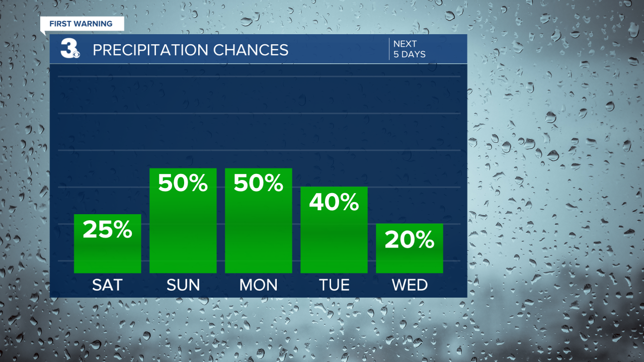
Some wet weather moves in this weekend. Spotty showers Saturday afternoon and evening, but a lot of areas will stay dry, so don’t cancel any outdoor plans. More clouds than sunshine and slightly warmer temperatures in the low to mid 80s. It will still be breezy with 10-15 MPH easterly winds. With that slight wind shift, we won’t have to worry about tidal flooding as much.
Temperatures climb a couple more degrees Sunday to highs in the mid 80s. A front will pass through, bringing us scattered showers and storms starting Sunday afternoon. This kicks off our unsettled pattern.
Scattered showers and storms continue Monday and Tuesday. Later Tuesday, a cold front passes through, putting an end to the rain, but barely touching temperatures. Mostly dry with more sunshine the second half of the workweek. Temperatures will be a degree or two cooler, still in the low to mid 80s the rest of the week.
Tropical Update:
Hurricane Earl is a Category 2 hurricane with 105 MPH sustained winds. It’s located 610 miles SSW of Cape Race, Newfoundland and is booking it NE at 29 MPH. Earl is forecast to remain in the Atlantic, eventually dissipating this weekend. It will continue to bring us locally a rough surf Saturday (5-7’ waves) and eventually bring that rough surf to Nova Scotia and Newfoundland.

Connect with Meteorologist Kristy Steward:
