


Meteorologist April Loveland's First Warning Forecast
Scattered showers and storms will be possible today as the outer rain bands of Tropical Storm Henri interact with a frontal system along the coast. Not expecting a washout, but make sure you keep your umbrella handy. Any showers or storms that occur could cause some flooding in areas that already received a lot of rain on Friday. Temperatures will warm to the low 80s, but it will feel closer to 90 degrees with the humidity. The water will be a dangerous place to be as Henri kicks up the surf. The red flags will be flying with a high risk of rip currents this weekend.
Temperatures will trend warmer on Sunday with highs in the upper 80s. Rain chances will continue to go down as Henri moves further away. Still keeping a chance for some afternoon showers and storms.
Hot and humid weather will be the story for the work week. Temperatures will soar to the upper 80s, but it will feel closer to the mid 90s. An afternoon isolated shower or storm will be possible.
The 90s will prevail Tuesday through Friday. Rain chances will remain around 20 percent for a spotty storm. Otherwise expect partly to mostly sunny skies. Heat index values will be near 100 degrees.
Tropical Update:

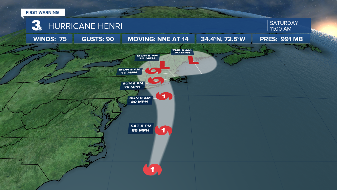
Tropical Storm Henri
Henri now a hurricane. Located about 180 miles ESE of Cape Hatteras, North Carolina. Henri is moving toward the north-northeast near 14 mph.
A faster northward to north-northeastward motion is expected today, followed by a decrease in forward speed and a turn toward the north-northwest on Sunday.
On the forecast track, Henri is expected to make landfall on Long Island or in southern New England on Sunday.
Maximum sustained winds have increased to near 75 mph with higher gusts. Additional strengthening is forecast through tonight. Although some weakening is expected prior to landfall on Sunday, Henri is forecast to be at or near hurricane strength when it reaches the coasts of Long Island and southern New England.
Hurricane-force winds extend outward up to 60 miles from the center and tropical-storm-force winds extend outward up to 125 miles.
Swells are expected to increase across much of the east coast of the U.S. and Atlantic Canada today and Sunday. These swells could cause life-threatening surf and rip current conditions.
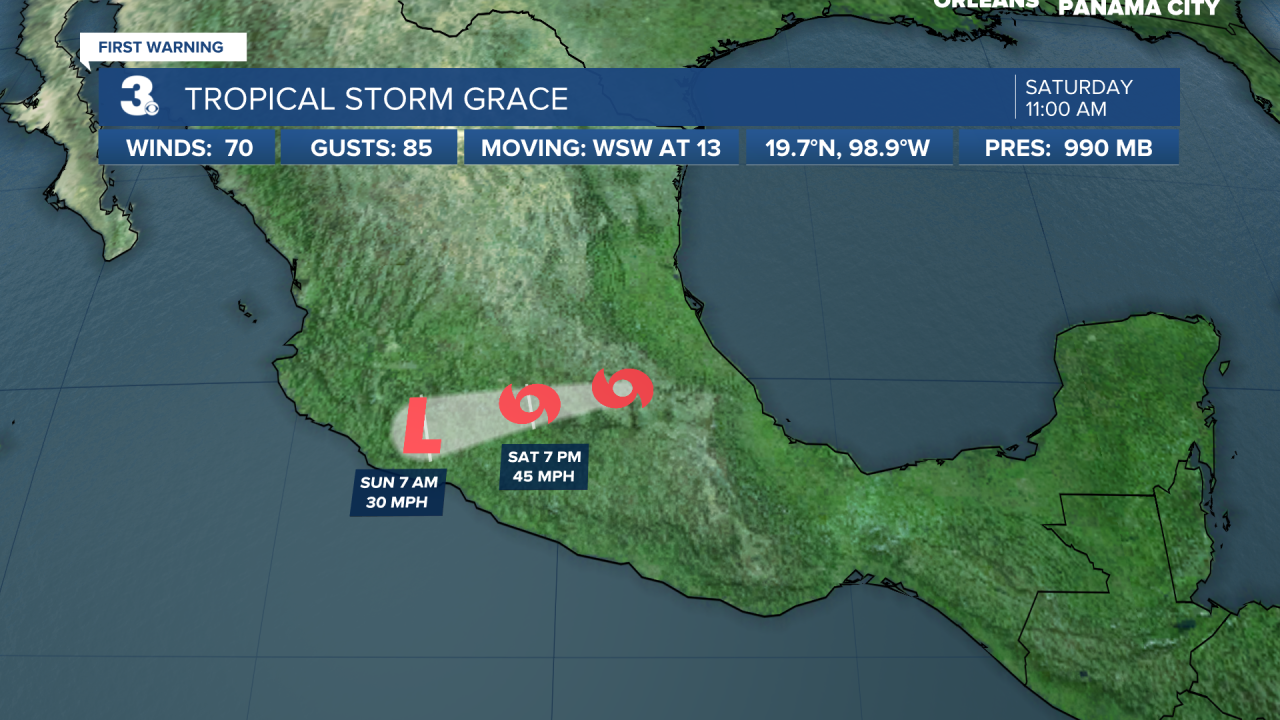
Hurricane Grace
Grace is weakening rapidly over land, but still causing very heavy rains. The storm is moving toward the west-southwest near 13 mph and a generally westward motion is expected into early Sunday.
On the forecast track, the center will move over central and west-central Mexico through tonight.
Maximum sustained winds have decreased to near 70 mph with higher gusts. Continued rapid weakening is expected while the system moves over the mountains of central and west-central Mexico today and tonight, and Grace is forecast to weaken to a tropical depression tonight and dissipate by early Sunday.
Tropical-storm-force winds extend outward up to 150 miles from the center.
Meteorologist April Loveland
For weather updates on Facebook: HERE
Follow me on Twitter: HERE
Follow me on Instagram HERE
Check out the Interactive Radar on WTKR.com: Interactive Radar
