


Meteorologist Kristy Steward's First Warning Forecast
Good Wednesday night! Warmer weather is finally headed our way, but the trade-off is severe storms. The line that’s been producing several tornadoes from Louisiana to Kentucky is heading our way. While it should lose some strength by the time it gets here, history tends to repeat itself with these lines and severe weather is still possible for us.
Tonight, clouds will continue to build and we’ll stay mostly dry ahead of that approaching strong cold front. The warm front from this system moves over us tonight, ushering in strong southerly winds and warmer air. Expect 10-20 MPH south winds gusting to 25 MPH. Secure any loose outdoor items tonight and tomorrow. Overnight lows in the upper 50s.
Thursday will start off dry throughout the morning and early lunch hours. However, it will be very windy. Southwest winds 15-25 MPH with gusts up to 45 MPH. Those strong southerly winds will help temperatures soar into the upper 70s.

The line of storms and severe threat will mainly be 2 PM - 9 PM. Most of the area is under a Level 2 severe risk. Our main threats are damaging wind gusts and isolated tornadoes.

Overnight Thursday into Friday, we dry out earlier in the night and clouds start to clear out later in the night. Overnight lows drop to the upper 50s.
Friday will be cooler, but still mild with highs in the upper 60s. Clouds continue clearing and winds stay breezy.
This weekend we’ll have a mix of sun and clouds. A few isolated showers are possible Sunday morning, otherwise it'll be a dry weekend. Highs Saturday around 60° and in the mid 60s Sunday. Overnight lows in the mid 40s both nights.
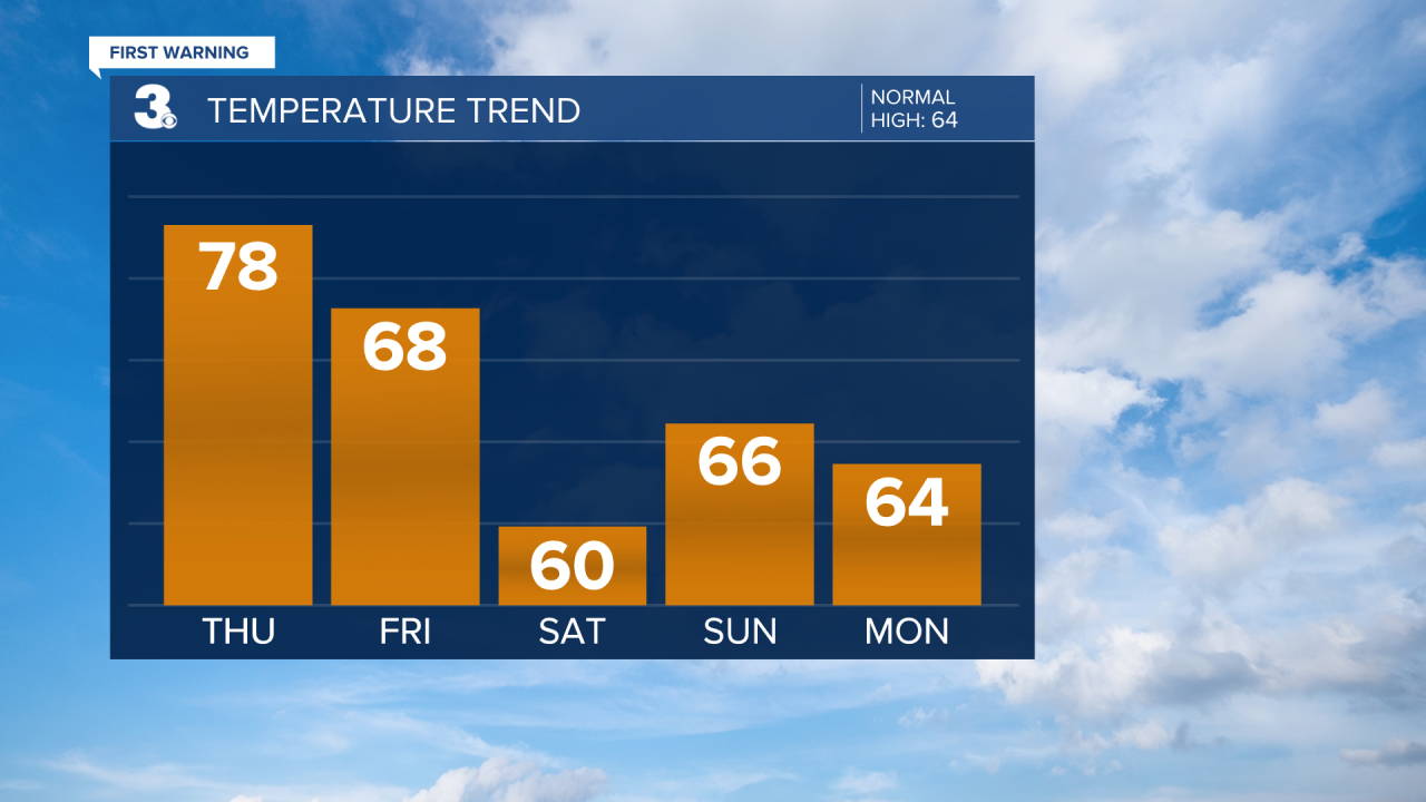
Monday stays in the mid 60s and dry with lots of sunshine. A warm front heads our way mid-week. That will bump our temperatures up to the low 70s beginning Tuesday. Clouds start building later Tuesday and scattered showers start falling Wednesday.
Connect with Meteorologist Kristy Steward:
