


Meteorologist April Loveland's First Warning Forecast
**Coastal Flood Warning in effect until 4 PM. Two feet of inundation above ground level expected in low-lying areas near shorelines and tidal waterways.

An area of low pressure off the coast of the Carolinas will continue to bring showers, wind and tidal flooding to the area today. Skies will be mostly cloudy with highs only in the low 70s. Winds will be out of the northeast at 15-25 mph, with gusts up to 30 mph. Tidal flooding will be one of the biggest issues today. High tide at Sewells Point is 1 PM. Moderate tidal flooding will be possible. Flooding will be possible for most areas along the tidal rivers, Chesapeake Bay, and Atlantic Ocean during high tide. Shallow flooding in the most vulnerable locations near the waterfront and shoreline is expected including some roads, parking lots, boat ramps and other property. The beach will be a dangerous place to be today. There is a high risk of rip currents with 4-8 foot waves. A few showers will be possible overnight, other expect overcast skies with lows in the mid and upper 60s.
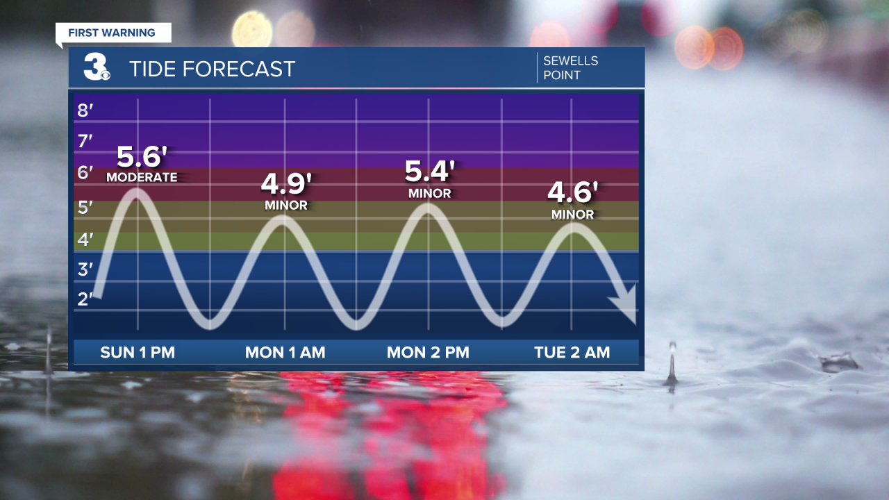
Isolated showers will be possible on Monday due to two areas of low pressure offshore. It will still be breezy and minor tidal flooding will be possible. Temperatures will warm to the mid 70s.
A few lingering showers will be possible on Tuesday, otherwise skies will start to clear as the day progresses. Highs in the mid 70s.
Warmer with more sunshine by Wednesday. Highs will be in the upper 70s to near 80 under partly cloudy skies.
More sunshine will break out on Thursday with highs near 80.
The warmer temperatures will carry into the end of the work week and weekend. Highs will be in the low 80s under partly cloudy skies.
Meteorologist April Loveland
For weather updates on Facebook: HERE
Follow me on Twitter: HERE
Follow me on Instagram HERE
Check out the Interactive Radar on WTKR.com: Interactive Radar
