


Meteorologist Kristy Steward's First Warning Forecast
Good Wednesday night! Most of us stayed dry today, but there were some spotty showers around. Spotty activity continues with cooler temperatures and stronger winds the next couple days. These stronger winds will also bring us tidal flooding.
Clouds stick around tonight. Lows in the upper 60s. Partly cloudy Thursday with highs in the low 80s. Some spotty showers here and there throughout the day.
While hurricane Earl will remain far out to sea in the middle of the Atlantic, as it strengthens and travels north, it will bring us a rougher surf. A high rip current risk Thursday with 4-7 feet waves at the beach. This rough surf will likely last through the weekend. It’s highly recommended to stay out of the water. If you happen to get caught in a rip current, remember to swim parallel to shore to escape the current.

We also stay windy the next few days with 10-20 MPH northeast winds. This will bring us minor tidal flooding during high tide the rest of the workweek, potentially into the weekend.

Friday and this weekend will be mostly dry and partly cloudy. Temperatures this weekend rise a couple degrees into the mid 80s. Highs remain in the mid 80s through at least the first half of the workweek.
If you’ve been looking for rain, our next greatest chance will be the first half of next week. Scattered showers and storms expected Monday and Tuesday, tapering off Wednesday.
Tropical Update:
Tropical Update:
Hurricane Danielle is a Category 1 hurricane with 75 MPH sustained winds. It’s still in the northern Atlantic and will continue to travel northeast until it eventually dissipates. Danielle poses no threat to land.

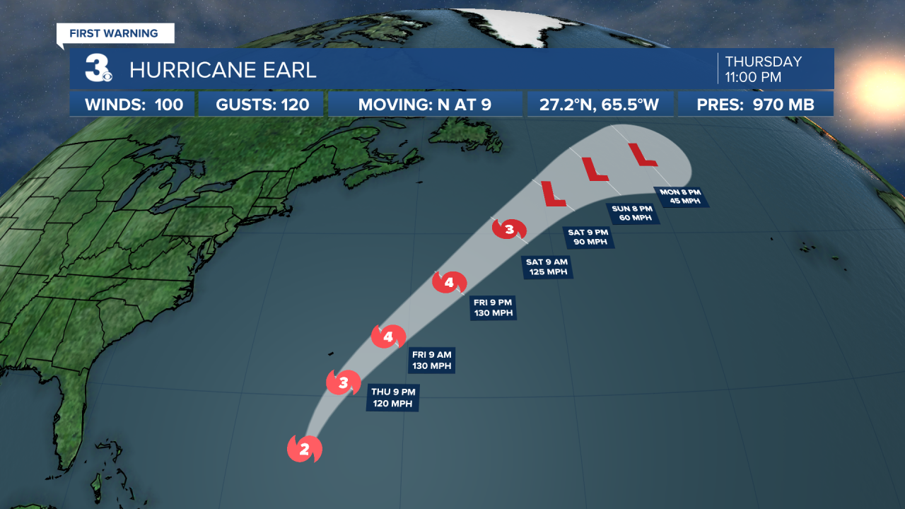
Hurricane Earl is now a Category 2 hurricane with 100 MPH sustained winds. It’s located 355 miles south of Bermuda and is moving N at 9 MPH. Earl is forecast to remain in the Atlantic, eventually strengthening into a Category 4 hurricane by Friday. It will bring us a rough surf through the weekend. Bermuda will feel tropical-storm-force winds the next couple days.
The tropics are keeping active. There are two additional areas currently being watched. One area of low pressure several hundred feet west of the Cabo Verde Islands has a 70% chance of formation in the next 48 hours. Another area of low pressure over the west coast of Africa has a 30% chance of formation in the next 5 days.

Connect with Meteorologist Kristy Steward:
FACEBOOK
TWITTER
INSTAGRAM
