


Meteorologist April Loveland's First Warning Forecast
Tracking a gorgeous weekend, followed by an unsettled work week.
Temperatures will continue to warm to near 80 with winds out of the southwest under mostly sunny skies and dry conditions.
Milder overnight with lows in the upper 50s and low 60s under mostly clear skies.
Another sunny and warm day Sunday. Temperatures will warm to the low and mid 80s. Dew points will start to rise a bit as well, so you will start to feel a little more moisture in the air.
More clouds build in overnight with lows in the mid 60s.
We've been spoiled with the dry weather and sunshine, but things are about to take a turn. Expect more cloud cover to start the work week as a slow moving cold front approaches the region. Highs will warm to the low 80s. Keeping a slight chance for a spotty shower.
Mostly cloudy on Tuesday with scattered showers. Highs will be in the low 80s.
Conditions will start to feel more humid by midweek. Dew points will rise to near 70. Scattered storms will be possible on both Wednesday and Thursday with highs in the mid and upper 70s.
Another chance for showers to end the work week. Highs will once again top out in the mid and upper 70s.
Tropical Update:
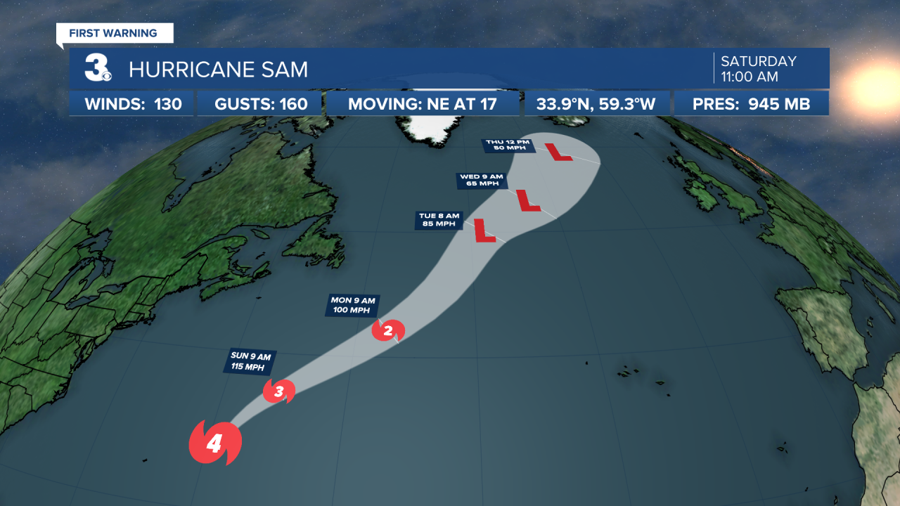
Sam is still a category 4 hurricane and is moving toward the northeast near 17 mph. This general track with an increase in forward speed is expected for the next few days. On the forecast track, Sam will continue to move away from Bermuda. Maximum sustained winds remain near 130 mph with higher gusts. Some slow weakening is forecast during the next 36 hours, followed by more significant weakening early next week. Sam could become a powerful post-tropical cyclone on Tuesday. Sam is becoming a large tropical cyclone. Hurricane-force winds extend outward up to 65 miles from the center and tropical-storm-force winds extend outward up to 240 miles.
Victor is moving toward the northwest near 12 mph, and this general motion is expected to continue over the next few days. Maximum sustained winds are near 40 mph with higher gusts. Gradual weakening is forecast over the next couple of days, and Victor could become a remnant low by tonight. The system is then forecast to dissipate by Tuesday. Tropical-storm-force winds extend outward up to 115 miles from the center.

Meteorologist April Loveland
For weather updates on Facebook: HERE
Follow me on Twitter: HERE
Follow me on Instagram HERE
Check out the Interactive Radar on WTKR.com: Interactive Radar
