


Meteorologist Kristy Steward's First Warning Forecast
Good Sunday evening! Today was another warm and windy day with scattered showers. Our weather is going to take quite the rapid turn with a low pressure system developing over the Carolinas and moving right over us. All types of weather are in store Monday.
Temperatures start dropping tonight and will continue to steadily drop throughout the day Monday. Temperatures will be in the low 40s Monday morning, feeling like the low 30s. By Monday evening, temperatures will be in the low 30s, feeling like the low 20s. These plummeting temperatures will transition our rain to a mix to snow throughout the morning tomorrow.
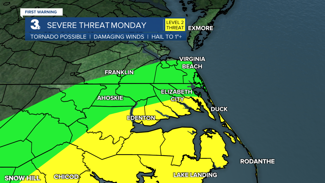
Tonight, widespread heavy rain will begin around 10 PM and continue into Monday morning. In North Carolina, we have the potential to see severe storms with damaging wind gusts and isolated tornadoes. The Albemarle Sound and Outer Banks is under a Level 2 severe weather risk. The rest of our North Carolina communities extending into Southside are under a Level 1 risk for severe weather. The most likely time for severe storms is 8 AM - 12 PM Monday.
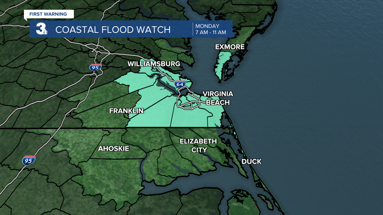
Aside from the storms, it's going to be extremely windy tomorrow. A Wind Advisory is in effect for our coastal communities including Currituck, inland Dare, Virginia Beach, Norfolk, Portsmouth, and Northampton (VA) from 7 AM - 7 PM Monday. 25-35 MPH north winds could gust up to 50 MPH. Having that strong of a northerly wind flow also raises the concern for coastal flooding. We have a Coastal Flood Watch in effect from 7 AM - 11 AM Monday for Southside and the Lower Peninsula including Isle of Wight, Norfolk, Portsmouth, Suffolk, Chesapeake, Virginia Beach, Northampton (VA), Surry, James City, Williamsburg, York, Newport News, Hampton, and Poquoson. Moderate tidal flooding is forecast with 2-3 feet inundation expected.

Around 10 AM Monday, we'll begin to see a changeover from rain to a quick mix to snow. This will be gradually happening from the northwest to the southeast from 10 AM - 1 PM. All precipitation will end Monday late afternoon/early evening around 6 PM. Because the ground is so warm and we will continue to have strong winds, it will be hard to see a lot of the snow sticking. However, it will be a wet snow and we could have some heavier bands at times, so that will help allow minor accumulations on some roadways, mainly across our northern communities.
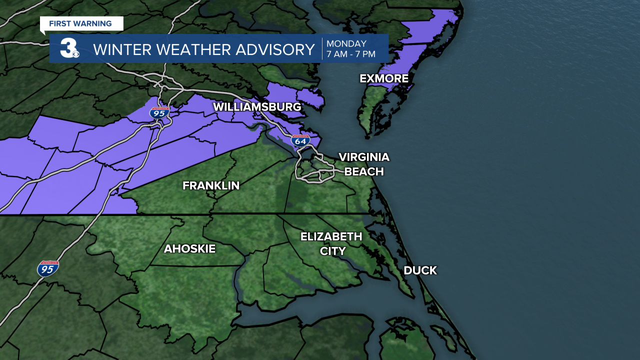
There is a Winter Weather Advisory in effect from 7 AM - 7 PM Monday for Gloucester, Mathews, Williamsburg, Surry, James City, Accomack, York, Newport News, Hampton, and Poquoson. These are the areas that have the best chance for higher accumulations and slick slushy spots on roadways.
As for snow accumulations, there's going to be a very sharp gradient between 3"+ and nothing. Northern Gloucester County could see 3-4" of snow while southern Gloucester may only see 1". For most in Virginia, it looks like 1-2" is where totals will fall. For northeastern North Carolina, maybe a light dusting. Again, these totals will primarily be found on grassy and elevated surfaces because the pavement is very warm.

Whatever wet spots don't dry out by Monday night, will likely turn into black ice as temperatures drop into the upper 20s. Lots of sunshine Tuesday will help melt those slick spots in the morning though. Tuesday will still be quite cold. Highs in the low 40s.
Temperatures rebound to the mid 50s Wednesday, but tumble back down to the low 40s Friday and Saturday following another cold front. This cold front will pass through Thursday night, bringing rain showers that may turn to snowflakes Friday morning.
A warm front from another system will briefly warm us up Sunday into the mid 50s again.
Connect with Meteorologist Kristy Steward:
