


News 3's meteorologists are tracking severe weather across the area Friday night into Saturday morning.
We're seeing a Level 3 severe weather threat in parts of Hampton Roads and northeastern North Carolina. That means much of the area could see strong to severe storms, high winds, hail and potential tornadoes.
Meteorologist Myles Henderson says storms are expected to begin after 4 p.m. and track northeast.
One wave of storms is expected between 5 p.m. and 9 p.m., and another wave is expected between 10 p.m. and 1 a.m.
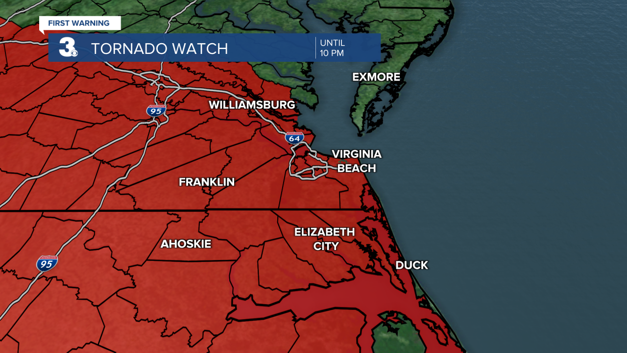
A Tornado Watch was declared for the area until 10 p.m. The only local areas excluded from the watch are Mathews and the Eastern Shore.
Our weather team will track the storms all afternoon beginning at 4 p.m. We'll also have live updates in this story.
Forecast:
FIRST WARNING: Tornado Watch for parts of the News 3 viewing area in NC until 12:00am. https://t.co/CLQpA5o10m
— Patrick Rockey WTKR (@PatrickRockey) May 7, 2022
FIRST WARNING: Tornado Watch for parts of the News 3 viewing area in VA until 12:00am. https://t.co/CLQpA5o10m
— Patrick Rockey WTKR (@PatrickRockey) May 7, 2022
TORNADO WATCH
— Myles Henderson (@MHendersonWTKR) May 6, 2022
Until 10 PM Friday
For most of SE VA and NE NChttps://t.co/Op35kWgP4y#FirstWarn3 pic.twitter.com/vu5XfkbMYe
Storm conditions/damage:
Southampton County
- 6:05 p.m. - The National Weather Service (NWS) reports power poles down near Sycamore Church Road and Dogwood Bend Road in Franklin due to high winds
- 6:05 p.m. - NWS reports a tree down near Monroe Road in Sunbeam due to high winds
Isle of Wight County
- 6:22 p.m. - NWS reports trees down off Mill Creek Drive in Dwight
Norfolk
A tree and a wire were knocked down in the area of Racine Avenue and St. Dennis Avenue in Norfolk just before 6 p.m.


Heavy rain in downtown Norfolk. Also, a high school prom at Nauticus is still going on despite the weather! A lot of kids having to brave the elements in their nice clothes. @WTKR3 pic.twitter.com/Ee7F6JvVeC
— Chip Brierre (@Chip_Brierre) May 7, 2022
Chesapeake
Nasty #storm in #Chesapeake right now! pic.twitter.com/bmAVmhytDm
— Ted Noah (@TedNoah) May 7, 2022
Virginia Beach
Severe storms are rolling through the Indian River and Lynnhaven Parkway area of VA Beach. #FirstWarn3 @WTKR3 @PatrickRockey pic.twitter.com/x2wePIXWfQ
— Gerardo (@grlopez7) May 7, 2022
Ahoskie, North Carolina
Intense rain with a brief period of hailstones (videos courtesy of @TropicalSaiel)
Storm preparation:
Norfolk will open several garages for residents to avoid having their cars damaged due to hail.
This is an important message from Norfolk Alert
WEATHER ADVISORY: Severe storms are expected to begin late this afternoon and coastal flooding throughout the weekend. Damaging wind gusts, hail, and the potential for tornadoes are possible. Residents can park for free in the York Street Garage and Brambleton Lot until noon on Monday, May 9. Tune to local weather stations for updates.
York County also announced that several garages will be open for residents to avoid hail or flooding damage to their cars.
Due to the concerns regarding the potential for flooding this weekend, the parking lot at Chisman Creek Park (1314 Wolf Trap Road) and the lots at the McReynolds Athletic Complex (412 Sports Way) are open for the parking of trucks, trailers, campers, RVs, boats, etc. If vehicles are moved to either park site, owners are asked to have them removed by Monday. Citizens are reminded to not park their vehicles at school sites.
School closures:
Due to an enhanced risk today for damaging winds and wind gusts, large hail, localized heavy rain/flash flooding, and the possibility of tornadoes, Edenton-Chowan Schools is dismissing at 12:30pm. All after school activities are cancelled. Please be safe!
Due to the threat of severe weather conditions this afternoon, Friday, May 6, Gates County Schools will close at 1 p.m. today.Daycare will close at 2 p.m. At this time, the high school prom is still scheduled, however, conditions will continued to be monitored and more information will be given later this afternoon.
Good morning, due to predicted severe weather this afternoon beginning around 3 pm, Camden County Schools will dismiss at 1 pm today, Friday, May 6, 2022. All after school activities have been canceled. Thank you for your support of Camden County Schools.
Perquimans County Schools will dismiss at 12:30 p.m. today.
