


NORFOLK, Va. — A pedestrian bridge over Norfolk Southern rail lines could connect West Ghent and Lambert's Point along the Elizabeth River Trail, and I got the first look at the design plans.
The Elizabeth River Trail is an urban trail that connects 28 neighborhoods and stretches 10.5 miles through Norfolk.
For years, the only way to travel between West Ghent and Lambert's Point on the trail has been through a narrow, dark underpass beneath Hampton Boulevard.
Kindra Greene, executive director of the Elizabeth River Trail Foundation, said the underpass has long been a barrier for trail users.
"We've heard from families that some of them just don't want to bring their children through it. It prohibits them from, you know, exploring this side of the trail," Greene said.
She said, to some trail users, the underpass has split the trail into two disconnected segments.
"Some people feel that we really don't have a 10.5-mile trail, we have a 7.5-mile trail and a 3-mile trail because it really bisects the connectivity," Greene said.
ERT Foundation leaders, volunteers, city officials, architects, engineers, and Norfolk Southern are now in early discussions about building a bridge over the railroad tracks.
"We're at the early, early stages of just talking, but the fact that we're having this conversation is amazing," Greene said.
Mel Price is the chair of the ERT Master Planning Committee and CEO and co-founder of Work Program Architects. WPA helped launch the foundation and provides master planning services pro bono.
Price played a key role in planning and designing the bridge concept.
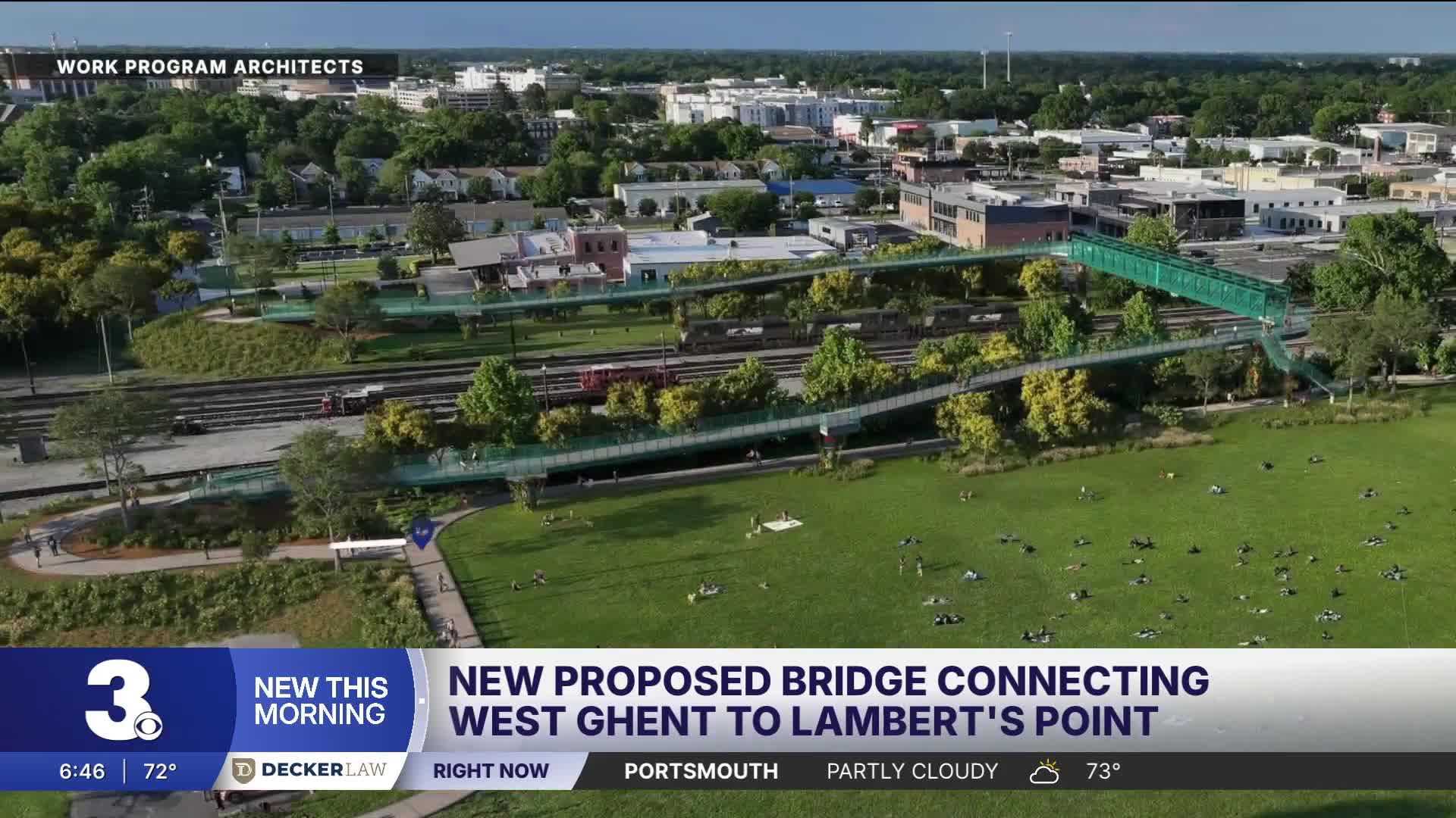
The first draft proposes a gradual, ADA-accessible slope that would extend from the trail in Jeff Robertson Park, loop along the tree line, cross the tracks (above the recommended height), and connect to the Railyard District near FR8 House Coffee Co., IPConfigure, and Afterglow Brewing.
The route would include benches, lighting, railings high enough to safely accommodate cyclists, and views of the Elizabeth River.
"The problem is we need to get people from [one side of the tracks to another], but we need to do it in a way that's safe and easy and comfortable," Price said.
A staircase would also be included for those who want a quicker route. The design incorporates contributions from local artists.
While aesthetics are part of the plan, Price said protecting train operations is a top priority.
"It'll be wrapped and covered to keep the trains and the train tracks safe and protected," Price said.
The project could take years to complete, but Greene said it represents a broader benefit for the community.
"So much of what we do here at the foundation is about quality of life for this community, and the trail sits at the intersection of public health and transportation and equity," Greene said.
The ERT Foundation is seeking public input so you can help shape the design plans and future conversations.
At this point, trail leaders are meeting with civic leagues and community groups to present the design and answer questions. Greene anticipates some type of online portal for people to share their thoughts. Those details will be announced as they become available.
The ERT Foundation is a nonprofit organization that relies on community support. The group will need to secure funding for the pedestrian bridge, which means relying on pro bono services and donations.
This story was reported on-air by a journalist and has been converted to this platform with the assistance of AI. Our editorial team verifies all reporting on all platforms for fairness and accuracy.
Click here to see how we use AI at WTKR News 3.
