


A coastal storm brought as many as 10 inches of snow to parts of northeast North Carolina Saturday into Sunday, with much of the Hampton Roads southside seeing multiple inches. Our live blog has been covering the storm with updates.
Monday, Feb. 2
6:18 a.m. — News 3 reporter Gabrielle Harmon gives an update on icy conditions in Norfolk.
The roads in the Ocean View neighborhood appear to be clear following a heavy amount of tidal flooding in the area; specifically, on Pleasant Avenue.
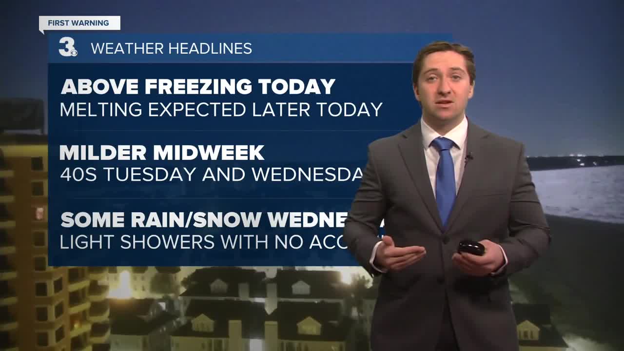
6:00 a.m. — Meteorologist Tony Nargi says this morning will start off very chilly with temps in the 20s and 10s with wind chills down in the single digits to below 0.

We'll see sunny skies throughout the day along with calming winds from NW at 10-15 mph in the morning down to W at 5-10 mph in the afternoon. High temperatures will reach the mid 30s, with above freezing temps and plenty of sun leading to lots of melting snow. Tonight will cool back down in to the 10s and 20s, with mostly clear skies expected.
Sunday, Feb. 1
7:30 p.m. — Some nuisance tidal flooding will be near the Lynnhaven Inlet between 7 om and 9 pm tonight. Tidal flooding will be the most prevalent at coastal locations facing east and/or closest to the Atlantic due to the winds and the moon's gravitational pull.

5:30 p.m. — Snowfall totals are in across the region! Most of the snowfall accumulated along the Carolina coast. A few cities even made snowfall records. Many look ahead to the big thaw this week with temperatures finally reaching above 32 degrees again.

4:25 p.m. — Dozens of school districts, including Norfolk, Portsmouth, Suffolk, and Chesapeake have announced closures, or virtual/asynchronous learning for Monday, Feb. 2.

Hampton Roads Closings & Delays
4:06 p.m. — The powerful nor’easter brought heavy snow and strong winds to the Outer Banks over the weekend, transforming the popular vacation destination into an unusual winter landscape and creating difficult travel conditions for residents.
Snowfall intensified Saturday evening and continued into Sunday morning, leaving roads coated in snow and ice.
By daylight, some residents were shoveling driveways, digging out vehicles, or simply enjoying the rare sight of snow-covered beaches.
News 3's Kamilah Williams was out with neighbors to hear about how they're digging out.
2:20 p.m. — News 3 Sports Director Marc Davis was out in Chesapeake Sunday taking a look at the aftermath of Saturday's snow storm.
12:56 p.m. — The weekend snowstorm that pummeled Elizabeth City with high wind, bitter cold, and multiple inches of snow was moving out Sunday. That meant the dig out was underway. “It’s not the most fun thing to do," said Leonard Loucks, who was using a tractor to clear snow out of a shopping center parking lot. "I was born and raised in Pennsylvania, so I was hoping I was getting away from all that mess," said Loucks.
Crews could be seen around the city, starting before the sun came up Sunday, working to clear snow. There was plenty of snow to be cleared Sunday after the snow came down hard and fast for several hours Saturday. Along with the snow on the ground, the strong wind and cold persisted. “I always try to help out," Landon Lewis said as he shoveled snow off a sidewalk around a Dunkin’ Donuts. "It’s pretty easy [to shovel.] It’s powdery.”
Luckily, many will get at least one extra day to let snow clearing happen before having to get out and about. Class is canceled Monday for Elizabeth City-Pasquotank Public Schools students. Teachers and staff will have an optional work day.
11:43 a.m. — A high surf advisory is in effect at the Virginia Beach Oceanfront as strong winds continue to push Atlantic waves onshore.
10:55 a.m. — Here's some of the peak wind gusts from last night's storm

10:32 a.m. — Businesses in the Ocean View area of Norfolk are closing up shop Sunday due to the high winds and flooding in the area.
10:18 a.m. — Snow totals updated for Hampton Roads and northeast North Carolina.
Norfolk 2.0”
Norfolk Norview 2.0”
Portsmouth Downtown 2.0”
Portsmouth Cradock 2.0”
Portsmouth Western Branch 2.0”
Virginia Beach Sigma 1.6”
Virginia Beach Gallups Corner 2.5”
Virginia Beach 3.0”
Chesapeake Great Bridge 3.7”
Chesapeake Great Bridge 3.0”
Chesapeake Herberts Corner 2.5”
Chesapeake Hickory 2.0”
Chesapeake Fentress 2.0”
Suffolk Kilby 2.0”
Suffolk Driver 1.8”
Suffolk Indika 1.5”
Suffolk Cleopus 3.0”
Suffolk Whaleyville 2.0”
Suffolk Hobson 1.0”
Southampton Sunbeam 5.0”
Southampton Zuni 1.0”
Franklin Hunterdale 3.8”
Sussex Wakefield 1.0”
Newport News 1.5"
Currituck Grandy 10.0”
Currituck Moyock 5.0”
Gates Easons Crossroads 3.0”
Pasquotank Nixonton 5.5”
Pasquotank Weeksville 6.0”
Pasquotank Elizabeth City 7.0”
Pasquotank Elizabeth City 5.0”
Pasquotank Elizabeth City 5.8”
Pasquotank Spences Corner 5.0”
Perquimans Hertford 7.0”
Northampton Severn 4.0”
Hertford Murfreesboro 5.5”
Hertford Ahoskie 4.5”
Hertford Winton 3.5”
Bertie Kelford 7.0”
Bertie Aulander 8.0”
Camden Shiloh 4.5”
Chowan Saint Johns 7.4”
10:02 a.m. — High tide is bringing flooding to the Ocean View neighborhood in Norfolk. Anchor Anthony Sabella was out Sunday morning capturing these videos of the streets as they fill with water.
Neighbors can expect more flooding Sunday, continuing high winds, and frigid temps.
9:50 a.m. — Reporter Gabrielle Harmon was out near Lafayette Park Sunday morning where the temperatures were still frigid and the roads still uncleared.
9:37 a.m. — More snow totals are in from areas around Hampton Roads.
Norfolk 2.0”
Norfolk Norview 2.0”
Portsmouth Downtown 2.0”
Portsmouth Cradock 2.0”
Portsmouth Western Branch 2.0”
Virginia Beach Sigma 1.6”
Virginia Beach Gallups Corner 2.5”
Virginia Beach 3.0”
Chesapeake Great Bridge 3.7”
Chesapeake Great Bridge 3.0”
Chesapeake Herberts Corner 2.5”
Chesapeake Hickory 2.0”
Chesapeake Fentress 2.0”
Suffolk Kilby 2.0”
Suffolk Driver 1.8”
Suffolk Indika 1.5”
Suffolk Cleopus 3.0”
Suffolk Whaleyville 2.0”
Suffolk Hobson 1.0”
Southampton Sunbeam 5.0”
Southampton Zuni 1.0”
Franklin Hunterdale 3.8”
Sussex Wakefield 1.0”
Newport News 1.5”
Currituck Grandy 10.0”
Currituck Moyock 5.0”
Gates Easons Crossroads 3.0”
Pasquotank Nixonton 5.5”
Pasquotank Weeksville 6.0”
Pasquotank Elizabeth City 7.0”
Perquimans Hertford 7.0”
Northampton Severn 4.0”
Hertford Murfreesboro 5.5”
Hertford Ahoskie 4.5”
Hertford Winton 3.5”
Bertie Kelford 7.0”
Camden Shiloh 4.5”
9:04 a.m. — Speaking to Dare County officials Sunday morning, WTKR reporter Kamilah Williams learned that the ocean claimed yet another house in Buxton.
There is significant overwash on NC-12 between the Basnight Bridge and Rodanthe, flooding in Hatteras, and hundreds without power.
(Photo credit: Don Bowers, the Island Free Press)


9:00 a.m. — Here's some snow totals from Hampton Roads. A general 1-3" fell across the region last night, with some locally higher amounts.

8:40 a.m. — Tidal flooding is beginning to envelop some low lying roadways. Here's the scene on the corner of Boush St and Olney Rd in downtown Norfolk.


8:38 a.m. — Dozens of churches are closed or going virtual today. Updates on the latest cancellations & closings here.
Hampton Roads Closings & Delays
7:50 a.m. — Snow totals from around the region.


5:25 a.m. — Coastal flooding is expected this morning, with minor flooding expected into Norfolk. Some areas could see moderate tidal flooding in Southside and the Eastern Shore, with major tidal flooding expected along the Outer Banks. NC-12 will likely see some overwash this morning, avoid travel on the Outer Banks especially with the snow and winds along with the overwash.

4:30 a.m. — Snow is winding down but the wind is still howling. Gusts over 50 mph have been recorded across coastal areas, with gusts still reaching over 50 mph at ORF this morning.


Saturday, Jan 31
10:38 p.m. — News 3 Virginia Beach reporter John Hood ran out onto the Oceanfront boardwalk briefly to capture this video of the wind late Saturday. Visibility was very low given the combination of wind and snow.
10:18 p.m. — Photos sent in by Nadya Ayres show the storm at the Oceanfront from the boardwalk.


10:03 p.m. — Video from a high rise building at the Virginia Beach Oceanfront shows the wind whipping up the snow on the beach late Saturday night.
9:41 p.m. — News 3 reporter Brendan Ponton reported measuring 2" of accumulation from Virginia Beach Town Center Saturday night, with flakes still falling.

Video from the area also showed high winds whipping up the snow into the street.
8:30 p.m. — Snowfall totals are starting to come in. Here's how much is being reported in our neighborhoods to far:

8:15 p.m. — Local photographer Shawn Brooks sent WTKR video of the snow coming down pretty hard at the Oceanfront Saturday night along Atlantic Avenue.
Neighbors in Norfolk, Chesapeake, Suffolk and elsewhere in the 757 have also reported snow — though accumulation has been minimal.
6:30 p.m. — In Elizabeth City during our 6:30 p.m. newscast, reporter Colter Anstaett fought through snow, wind and frigid temps to give an update on conditions.
5:41 p.m. — Snow is slowly nudging in from southeast to northwest. A little bit of mixing is occurring near Hatteras. The snow will continue through the overnight and end before day break for most locations. A few snow showers will linger along the North Carolina coast but we'll all be dry by Sunday afternoon.

Just after sundown, video from Jennette's Pier showed the iconic fishing pier getting battered by wind and waves as the storm moved through.
2:53 p.m. — Our four main forecast models — the GFS, GRAF, NAM, and ECMWF — have all taken down their snow forecasts for the Southside significantly. While they all agree there will be some snow, totals range on these models from 1-3.2". Northeast North Carolina should still expect to see significant accumulation.

12:15 p.m. — Snow is finally starting to reach the ground, with live cams in Currituck and Dare Counties confirming snow along with light snow observations in Elizabeth City and Currituck. As the atmosphere saturates more flakes will start to fly across Northeast NC and Southeast VA.


11:00 a.m — Winds gusts are still on the lighter side right now, but are expected to ramp up this afternoon through the evening. Wind gusts could exceed 60 mph on Cape Hatteras, with gusts over 40 mph expected up and down the coastline!


8:30 a.m. — Snow is starting to fill in on radar ... but it's not quite hitting the ground. Some flurries are possible this morning, but dry air aloft is evaporating most of the snow before it reaches the ground. Midday through this afternoon snow should overcome that dry air and start to accumulate.


5:30 a.m. — This mornings update brings just minor changes to the expected snowfall map as the storm begins to develop offshore. Snow breaks out around midday in North Carolina, and during the afternoon into Southside and the Peninsulas. The heaviest snow will be Saturday evening, with snow tapering off Sunday morning.

Wind gusts over 40 mph are expected along the coast tonight, with gusts over 30 mph inland. Wind gusts up to 60 mph are possible on the Outer Banks, and could cause power outages tonight. Winds will subside Sunday afternoon.


Tidal Flooding is expected along the coastline on Sunday morning thanks to the strong N/NE winds driving water onshore. Sunday Mornings high tide between 7 am and 9 am will be the worst, with moderate to major flooding expected for many. Nuisance to minor tidal flooding will be possible on Sunday evening and Monday morning.


Extreme Cold Warnings are in effect Sunday morning as wind chills drop below zero as the storm departs. Dangerously cold temperatures last throughout the day Sunday, with frigid temps sticking around to begin next week.

Friday, Jan. 30
9:50 p.m. - From Chief Meteorologist David Aldrich. One of the most important rules to remember in winter, in terms of expectation, is the following:
"At some point... precipitation has to end." I suppose there could be a perceived mystery to it. Why does one neighborhood get a rain shower in spring or summertime and a nearby town does not. Well, it's kind of like that. This weekend, expect strong gusty winds EVERYWHERE throughout the 757 and Northeast North Carolina. We do have a HIGH WIND WARNING in effect along the coast. But in terms of snow....at some point, precipitation has to end. This means our expectation is that much of North Carolina will be dealing with pockets of heavy snow, treacherous roads, blowing and drifting, etc, but other parts further North in the 757 may be left wondering..."Is that it? Is that all I getting?" The answer is yes. If you live NORTH of Norfolk, confidence keeps dropping on the amount of snow accumulation for you. Hope this helps.
Why is this? It is because of last minute adjustments in the storm's track that can make neighborhoods 10 to 30 miles apart to have VASTLY different outcomes this weekend.

7:00 p.m. — With all of the talk about snow, we'd be remiss if we didn't mention that this weekend if forecast to be our coldest weekend so far this winter... and it could be our coldest weekend of the year! Derrah Getter says we finally break our "subfreezing" streak next week when temperatures make a run for 40 degrees.

The snow forecast has also been taken down to closer to what we estimated on Thursday: 2-4" for the Southside, 4-8" for Currituck and Elizabeth City, and still more possible for areas inland North Carolina.

4:24 p.m. — The National Weather Service has issued a High Wind Warning (highlighted in orange) for areas that are forecast to see isolated 55+ mph wind gusts. Areas in beige under a Wind Advisory are forecast to see 40-50 mph wind gusts. Where the strongest winds persist, blowing snow, reduced visibility, fallen tree limbs and even power outages will be possible.

1:13 p.m. — Derrah Getter says along with snow, blustery wind, and tidal flooding, Sunday morning will be our coldest morning so far this winter! Wind chill values will be below 0 degrees across Hampton Roads.

Snow starts Saturday first for portions of the Outer Banks. Northeast North Carolina is where we’re expecting some of the highest totals. 8-10'’ of snow will be possible, but some spots could see isolated amounts of up to 12’’.
The snow will spread from south to north throughout the afternoon and evening on Saturday. Snow begins later in the day for Hampton Roads. Anywhere from 4-6'’ is expected. Snowfall amounts get lower the farther north you go. Areas like Williamsburg, Gloucester, James City Co., and Yorktown can expect 1-3'’.
10:26 a.m. — A coastal storm is expected this weekend, bringing a mix of snow, strong winds, and the potential for flooding across the region. For most areas, snow will dominate the forecast, though the southern Outer Banks could see some rain mixing in. The system will begin Saturday morning and wrap up by Sunday morning, gradually intensifying throughout Saturday. Wind gusts could reach 40 mph inland, with 50–60 mph possible along the coastline. These strong winds, combined with high tide on Sunday morning, raise the risk for coastal flooding, including overwash along the Outer Banks.
Snow showers will start off light on Saturday morning but become more widespread as the day progresses. On Sunday, snow showers will taper off by midday. Unusually for the area, the highest snowfall totals, around 4-8 inches or more, are expected in the south and east, extending into northeastern North Carolina, with much lower accumulations to the north due to a sharp drop-off.
Alongside the snow, winds will strengthen through Saturday, peaking Sunday morning. This combination of heavy snow, wind, and tidal influences means areas along the coast should be prepared for significant travel impacts and localized flooding during the storm’s peak.

6:11 a.m. — We are watching another chance for wintry weather this weekend as an area of low-pressure develops to our south and slides up the East Coast. The track of the low will determine how much snow we see (closer to the coast, more snow, away from the coast, less snow).
Snow will build in Saturday morning and pick up through the day. Snow will move out Sunday morning to midday. Most of the area will see snow but some rain could mix in for the southern Outer Banks. Higher snow totals are likely to the south and east (4” to 8”+) and lower totals to the north and west (1” to 4”).
Thursday, Jan. 29
11:30 p.m — David Aldrich. The latest GRAF model from late tonight continues to show a larger and heavier snow solution in North Carolina, while lesser amounts of snow can be expected across the Peninsulas and the Eastern Shore. With many more models to review, Senior Meteorologist Myles Henderson will be here first thing in the morning to update you on the latest changes to our forecast.


9:45 p.m. — David Aldrich. There are strong reasons why snow maps for winter events that start more than 3 days out are not posted publicly. The reason? Because things change. Take one of the most popular computer models in the U.S. called the Global Forecast System (GFS) model. 24 hours ago, it was projecting a solution of 19" to 24" inches of SNOW in the Southside. As extreme as that may seem, the very same model, the GFS, 24 hours later, which is today, dropped the Future snowfall totals in the Southside to 3.2". Stay tuned. There are bound to be more changes made to the forecast on Friday.

7:00 p.m. — Derrah Getter gives an update on this weekend's forecast. Blizzard conditions are anticipated but it doesn't mean what most people think. A blizzard doesn't have anything to do with the amount of snow accumulation. It is defined as 3 consecutive hours or more of 1/4 visibility or less due to blowing and/or falling snow with winds 35+ mph. Technically there can be a blizzard with no snow falling to the ground.

5:15 p.m. — Chesapeake Neighborhood Reporter Erin Holly visited a hardware store in Chesapeake to check how neighbors are preparing for another winter storm set to hit Hampton Roads this weekend, just a week after the last winter weather event.
At Taylor's Do It Center on South Battlefield Boulevard, customers like Scott Duffy found traditional ice melt sold out at many local stores, leading shoppers to settle for pool salt as an alternative that works slower but gets the job done. Duffy, an Uber driver with all-wheel drive, says he actually benefits from winter weather as rates increase due to supply and demand when fewer drivers are on the road.
Store manager Sherri Wheatley said an emergency shipment will arrive Friday after 1 p.m., and will include propane tanks, propane heaters and snow shovels for customers preparing for the weekend storm. Other shoppers like Hedley Austin and his dog Penny are simply planning to enjoy the snow in their backyard, with Penny excited to jump and run around in the winter weather.
Watch story: Chesapeake neighbors settle for pool salt ahead of another weekend winter storm
5:00 p.m. — There is a high probability now that we receive some blowing and drifting snow with tidal flooding this weekend. The higher totals still favor the Tar Heel State of North Carolina.
And while the models continue to show a wide range of snow totals, consistency in the data is still lacking. Be prepared for more snow updates in the hours and days to come.

4:41 p.m. — Private snow removal companies in Hampton Roads are preparing for another winter storm by pretreating parking lots and getting equipment ready.
Affordable Cuts is deploying up to 70 plows to service dozens of shopping centers and businesses from Richmond to Hampton and Williamsburg. The biggest challenge crews face is dealing with traffic during and after snowfall when trying to keep neighborhood businesses accessible. The company is asking residents to stay off roads during the storm so crews can safely clear parking lots and VDOT can handle the streets.
Watch story: Private plows ready for weekend snow storm
3:33 p.m. — Chief Meteorologist David Aldrich is dropping his expected snow totals for the area this weekend. The system — which is still forming — appears to be trending south, with more snow expected in the Outer Banks and the Albemarle, and less for metro Hampton Roads.
The Peninsula areas that got battered last weekend are likely to get trace amounts and be most unscathed.
Currently, we're confident there will be 2-4 inches on the southside, trace amounts further north, and possibly 4-8 inches in the Outer Banks and northeast North Carolina.

12:45 p.m. — Forecaster Derrah Getter breaks down snowfall probabilities.
This weekend we’re tracking widespread snow showers. As for specifics, it is too soon to say for certain exactly how much, but there’s a decent chance we’re going to see at least three inches. Snow showers start Saturday morning and last through Sunday morning. Gusty winds could lead to reduced visibility due to blowing snow.
In addition to the snow, there will be tidal flooding with the approaching full moon cycle.

12:33 p.m. — In addition to the winter weather we're expecting, we are also going to see high winds and tidal/coastal flooding. Watch out for flooding near times of high tide this weekend and ocean overwash on the Outer Banks.

Wind gusts could be in the 30-40mph range, depending on where you live.

9:35 a.m. — With a Winter Storm Watch in effect as of Thursday morning, we're breaking down the difference between a Watch, an Advisory, and a Warning (the most severe of the three).
According to NWS, the Watch means conditions are favorable for a storm event that could be a threat to people or property. These can indicate 3-6 inches of snow within a 12-hour period, seven inches within a 24-hour period. Watches also are issued when ice may damage power lines and trees.
A Winter Weather Advisory is typically issued for freezing rain, but with less potential accumulation. This is not quite as serious as a Winter Storm Warning.
A Winter Storm Warning is the highest cause for concern. Warnings indicate a significant heavy snow hazard within 12-36 hours is highly likely. This also includes the potential for tree and power line damage and a life-threatening combo of snow or ice with wind.
5:00 a.m. — Meteorologist Myles Henderson explains different impacts of this weekend storm's "inside track," "coastal track" and "outside track."

The track of the low will determine how much snow we see (closer to the coast, more snow, away from the coast, less snow). As of now, the "inside track" is looking unlikely. The "coastal track" would bring us 6" to 12" of snow. The "outside track" would bring us 1" to 6" of snow.
